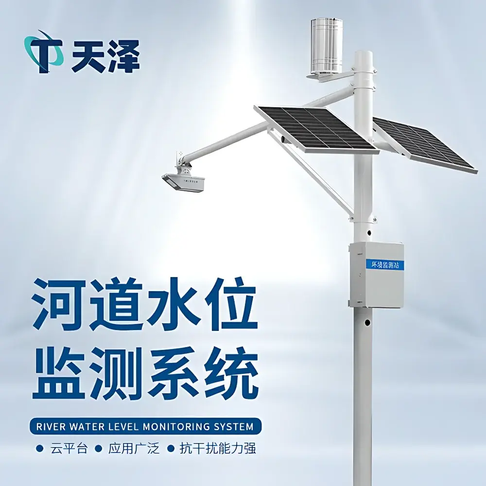
Tianze Environmental TZ-SW3A Non-Contact Radar-Based Open-Channel Flow Monitoring System
| Brand | Tianze Environmental |
|---|---|
| Model | TZ-SW3A |
| Measurement Principle | K-Band Planar Array Radar (24 GHz) |
| Water Level Range | 0.1–40 m |
| Water Level Accuracy | ±5 mm |
| Water Level Resolution | 1 mm |
| Surface Velocity Range | 0.15–15 m/s |
| Velocity Accuracy | ±2% of reading |
| Velocity Resolution | 0.01 m/s |
| Rainfall Intensity Range | 0–4 mm/min |
| Rainfall Accuracy | ±0.2 mm |
| Rain Collector Orifice | Ø200 mm |
| Operating Temperature | −35 °C to +60 °C |
| Storage Temperature | −40 °C to +60 °C |
| Enclosure Rating | IP68 |
| Power Supply | 12 V DC (100 mA operational, <1 mA standby) |
| Output Interface | RS485 / MODBUS RTU |
| Communication Protocols | HJ-212, HTTP, TCP |
| Solar Power Option | 100 W panel + 3.7 V / 10 Ah LiFePO₄ battery |
| Mounting | 3 m vertical pole + 3 m horizontal arm |
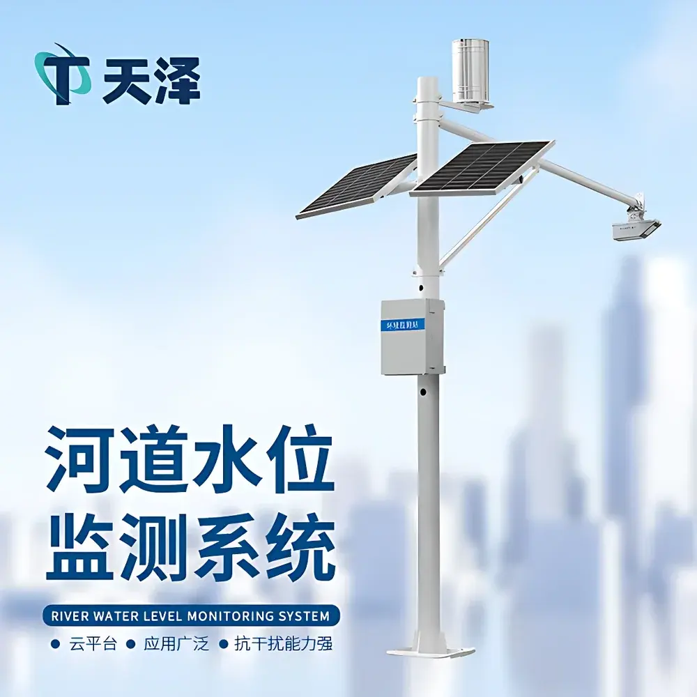
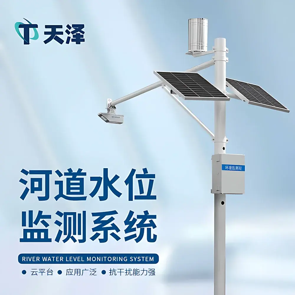
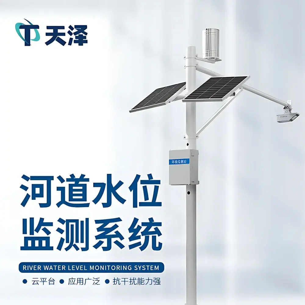
Overview
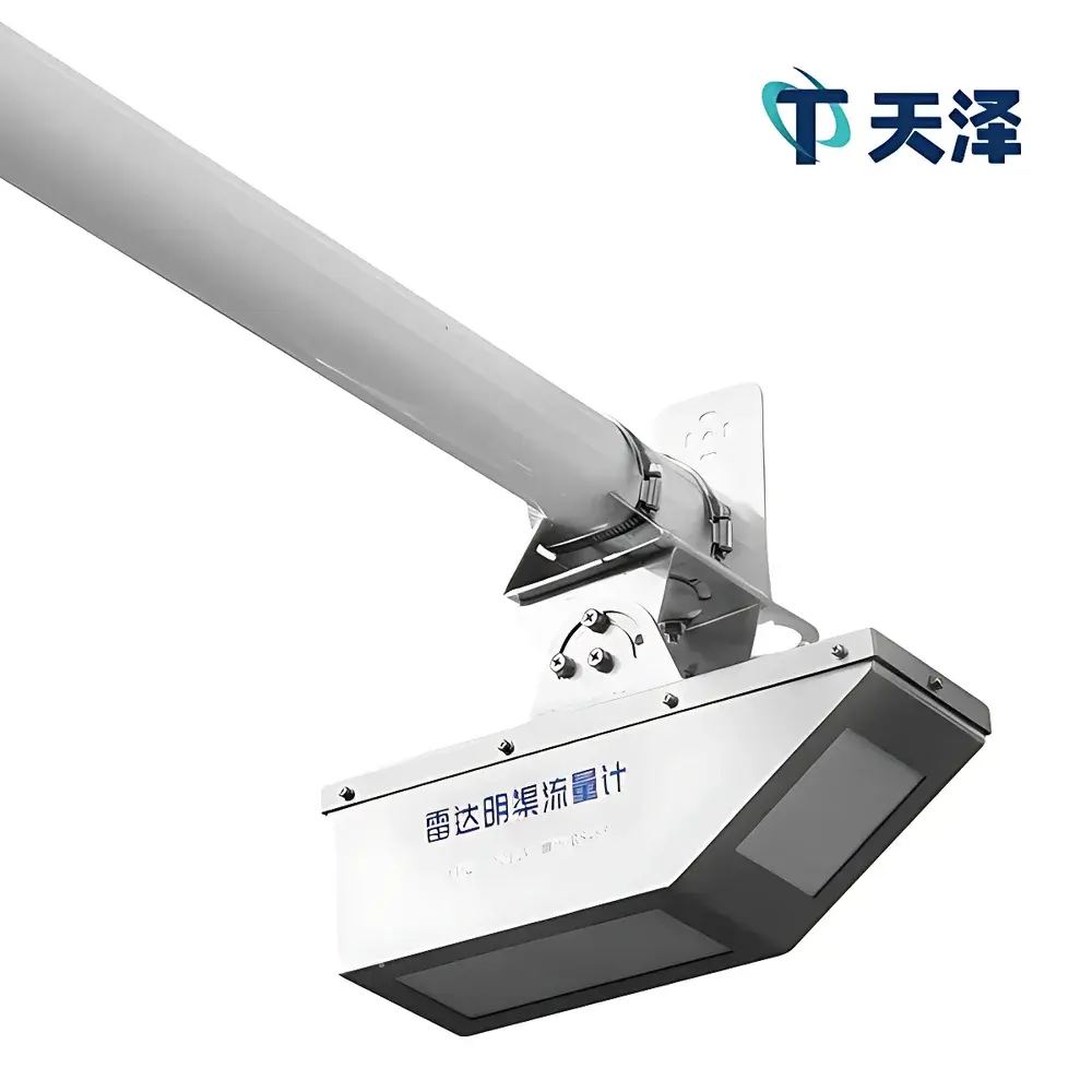
The Tianze Environmental TZ-SW3A is an integrated, non-contact open-channel flow monitoring system engineered for continuous, unattended hydrological observation in natural and engineered water conveyance systems. It employs 24 GHz K-band planar array radar technology to simultaneously acquire surface water level and surface velocity—two fundamental parameters required for real-time discharge computation. Unlike ultrasonic or pressure-based sensors, the TZ-SW3A operates without physical contact with the water surface, eliminating risks of fouling, corrosion, or mechanical drift. Its measurement principle relies on coherent Doppler shift analysis for velocity and time-of-flight (ToF) radar ranging for level detection—both inherently insensitive to ambient temperature gradients, atmospheric humidity, suspended solids, floating debris, foam, or surface turbulence. The system computes instantaneous volumetric flow rate using the continuity equation: Q = Vavg × A × C, where Vavg is derived from calibrated surface velocity profiles, A is the wetted cross-sectional area calculated from real-time water level and pre-configured channel geometry, and C is a site-specific hydraulic correction factor. Designed for long-term deployment in remote or harsh environments, the TZ-SW3A meets field durability requirements for flood forecasting, irrigation management, wastewater infrastructure monitoring, and regulatory compliance reporting.
Key Features
- True non-contact operation using dual-mode K-band radar: independent, simultaneous acquisition of water level and surface velocity
- IP68-rated ruggedized enclosure rated for continuous outdoor exposure across −35 °C to +60 °C operating range
- Low-power architecture supporting solar-battery hybrid power supply (100 W PV panel + 3.7 V/10 Ah LiFePO₄ battery)
- Self-contained flow calculation engine with configurable hydraulic models (e.g., Manning’s equation, user-defined stage-discharge curves)
- Integrated tipping-bucket rain gauge (Ø200 mm orifice) compliant with WMO Class B specifications
- Modular mounting design: 3 m vertical mast + 3 m cantilevered arm enables optimal beam alignment over trapezoidal, rectangular, or irregular channels
- On-device parameter configuration via web-based interface—no proprietary software or local installation required
Sample Compatibility & Compliance
The TZ-SW3A is validated for use in diverse open-channel geometries including concrete-lined irrigation canals, earthen riverbanks, reinforced stormwater conduits, and partially filled underground drainage pipes. It supports standard hydraulic cross-section definitions (e.g., trapezoidal, triangular, parabolic, custom polygonal) and accommodates variable roughness coefficients per ISO 14310:2017 (Hydrometry – Velocity-area methods for open-channel flow measurement). While not certified to IEC 61508 or SIL standards, its hardware architecture conforms to EN 60529 (IP68), and its data output protocols—including HJ-212 (China’s Environmental Monitoring Data Transmission Standard) and MODBUS RTU—are compatible with SCADA-level integration into municipal water management platforms. For regulatory reporting under China’s “Technical Specification for Automatic Monitoring of Surface Water Quality” (HJ 91.2–2022), the system provides traceable timestamps, audit-ready data logs, and configurable alarm thresholds aligned with GLP-aligned field data integrity practices.
Software & Data Management
The TZ-SW3A operates a browser-accessible, client-server (CS) architecture hosted on secure cloud infrastructure. Users access live dashboards, historical trend charts, georeferenced device maps, and exportable CSV/Excel reports directly via any modern web browser—no plugin or desktop application required. The platform supports role-based multi-user authentication, granular permission controls, and automatic daily backups stored in redundant object storage. All measurements are timestamped with millisecond precision and include metadata such as signal quality index, beam angle status, and battery voltage. Data forwarding is supported via HTTP POST, TCP socket streaming, and native HJ-212 protocol framing for seamless ingestion into provincial environmental monitoring centers. Advanced users may deploy custom JavaScript post-processing scripts on the server-side for unit conversion, anomaly filtering, or statistical aggregation—enabling adaptive calibration workflows without firmware updates.
Applications
- Flood early-warning systems in mountainous watersheds and urban drainage networks
- Irrigation district water allocation and loss auditing in gravity-fed canal systems
- Regulatory compliance monitoring at wastewater treatment plant influent/effluent points
- Stormwater runoff quantification for green infrastructure performance verification
- Real-time hydropower intake flow estimation in small-scale run-of-river installations
- Long-term sediment transport studies requiring synchronized velocity, level, and rainfall time series
FAQ
What hydraulic assumptions does the TZ-SW3A make when calculating flow?
It applies the velocity-area method using surface velocity as a proxy for mean cross-sectional velocity, corrected by empirically derived or site-calibrated coefficients (e.g., 0.85–0.95 for prismatic channels). Users must input accurate channel geometry and roughness parameters.
Can the system operate during heavy rainfall or fog?
Yes—K-band radar penetrates rain, mist, and airborne particulates with negligible attenuation; no optical or acoustic path is involved.
Is field recalibration required after initial setup?
No routine recalibration is needed. However, periodic validation against tracer dilution or ADCP surveys is recommended for critical applications per ISO 748:2021.
Does the device support NTP time synchronization?
Yes—automatic time sync via configurable NTP server ensures traceable timestamps across distributed deployments.
How is data security ensured during cloud transmission?
All HTTP and TCP communications are encrypted using TLS 1.2+, and device authentication uses certificate-based mutual TLS (mTLS) for API access control.