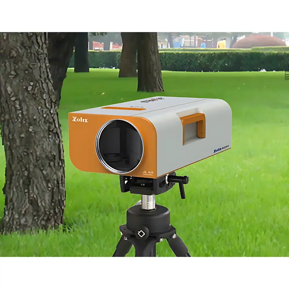
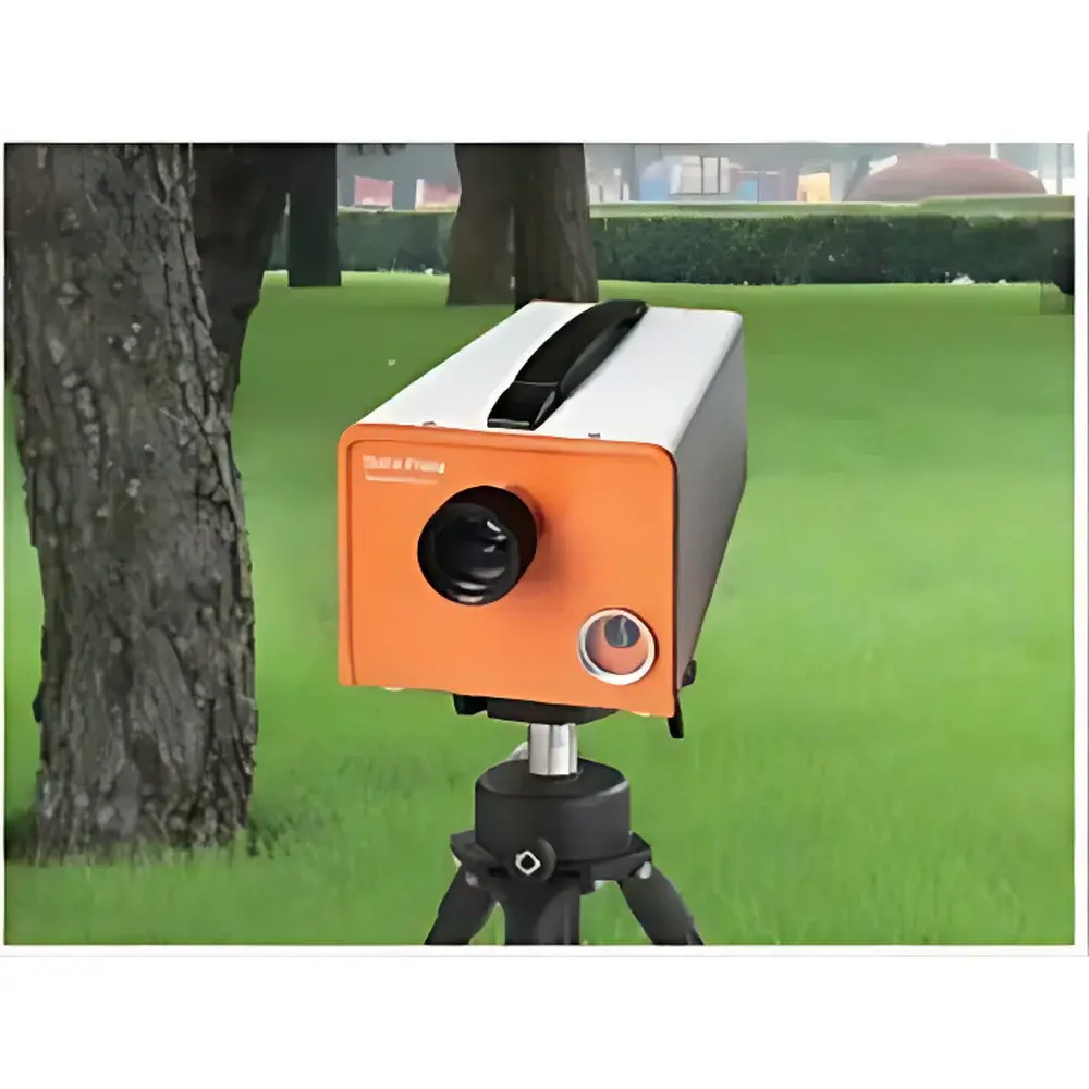
ZOLIX GaiaField-V10E Portable Ground-Based Hyperspectral Imaging System
| Brand | ZOLIX |
|---|---|
| Origin | Beijing, China |
| Manufacturer Type | Original Equipment Manufacturer (OEM) |
| Country of Origin | China |
| Model | GaiaField-V10E |
| Spectral Range | 400–1000 nm |
| Spectral Resolution | <3 nm |
| Spatial Resolution (IFOV) | <0.1° |
| Field of View (TFOV) | 20° |
| Image Resolution | 1392 × 1040 pixels |
| Frame Rate | 25–120 fps |
| Scanning Mechanism | Optomechanical Push-broom with Motorized Horizontal Scan (±22.5°, 45° total) |
| Detector Type | Uncooled CCD |
| Pixel Size | 6.45 × 6.45 µm |
| A/D Depth | 14-bit |
| Dynamic Range | 60 dB |
| Optical Interface | C-Mount |
| Lens Focal Length | 25 mm |
| f-number | F/2.4 (spectrometer), F/1.4–F/17 (lens) |
| Total Optical Throughput | >50% |
| Stray Light | <0.5% |
| Power Supply | Rechargeable Li-ion battery (≥8 h continuous operation) |
| System Weight | 8 kg |
| Form Factor | Hand-carried integrated unit |
| Data Output Format | Standard raw binary cube (.raw) compatible with ENVI, Specim IQ, and MATLAB |
Overview
The ZOLIX GaiaField-V10E is a field-deployable, optomechanically scanned push-broom hyperspectral imaging system engineered for ground-based remote sensing of terrestrial and aquatic targets at meter-scale standoff distances. Unlike snapshot or tunable-filter architectures, the GaiaField-V10E employs a high-throughput Czerny–Turner spectrograph coupled with a precision slit and a scientific-grade uncooled CCD detector to acquire spatially registered spectral data across the visible to near-infrared (VNIR) band (400–1000 nm). Its core measurement principle relies on spatial scanning—where horizontal angular displacement of the optical head (via motorized stage) combined with vertical field-of-view (20°) enables full-frame data cube acquisition without motion artifacts. Each acquired line image contains 1392 spatial pixels × ~1000 spectral channels (sampling interval ≤0.63 nm), yielding a hyperspectral data cube with native spectral resolution <3 nm—sufficient to resolve narrow absorption features associated with chlorophyll-a, anthocyanins, water vapor, and nitrogenous compounds in vegetation and surface waters.
Key Features
- Optomechanical push-broom architecture with motorized horizontal scan (45° total range, 0.05° step resolution) ensures geometric fidelity and radiometric consistency across large-area surveys.
- VNIR-optimized optical train: F/2.4 spectrograph with >50% total throughput and <0.5% stray light enables high signal-to-noise ratio (SNR) under ambient daylight conditions—critical for reflectance-based quantitative analysis.
- C-Mount-compatible 25 mm lens (F/1.4–F/17) provides flexibility in depth-of-field and irradiance control; calibrated field-of-view of 20° (vertical) × 45° (horizontal) yields a 3.5 m × 8 m imaged area at 10 m working distance.
- Real-time Ethernet-linked data acquisition at up to 120 line rates per second supports dynamic scene capture—including wind-induced canopy movement or flowing water surfaces—while maintaining full 14-bit dynamic range.
- Integrated rechargeable Li-ion power system delivers ≥8 hours of continuous operation, eliminating dependency on external generators during extended field campaigns.
- Hand-carried, tripod-mountable design (standard 1/4″-20 thread) with ±90° pitch and ±180° yaw manual adjustment facilitates rapid repositioning across heterogeneous terrain or elevated vantage points.
Sample Compatibility & Compliance
The GaiaField-V10E is designed for non-contact, passive reflectance measurement of natural and anthropogenic surfaces under solar illumination. It is routinely deployed for in situ characterization of vegetative canopies (crops, forests), inland and coastal water bodies (chlorophyll-a, suspended solids, CDOM), soil surfaces (moisture, organic carbon), and man-made materials (paints, coatings, camouflage fabrics). All hardware and firmware comply with IEC 61000-6-3 (EMC emission limits) and IEC 61000-6-2 (immunity requirements) for industrial environments. Data acquisition software logs timestamped metadata (GPS optional via external module), exposure settings, and calibration references—supporting traceability in GLP-compliant environmental monitoring workflows. While not FDA-cleared, its raw data format and metadata structure align with ISO 11146 (laser beam parameters) and ASTM E2795-18 (hyperspectral imaging for material identification) best practices.
Software & Data Management
The bundled acquisition software provides real-time visualization of both spatial frames and per-pixel spectra, enabling on-the-fly region-of-interest (ROI) selection and spectral library matching. All raw data are saved in vendor-neutral binary format (.raw) with header files containing wavelength calibration vectors, spatial sampling geometry, and radiometric gain/offset coefficients—ensuring direct ingest into ENVI, Python (scikit-image, spectral), MATLAB, or QGIS with minimal preprocessing. The software supports programmable exposure control (1 µs–120 s), frame averaging, dark current subtraction, and flat-field correction using onboard reference panels. Audit trails—including operator ID, session start/stop timestamps, and parameter change logs—are embedded in metadata for regulatory review. Export options include GeoTIFF with georeferencing tags (when paired with GNSS), CSV spectral profiles, and ENVI-compatible .hdr/.dat bundles.
Applications
- Agricultural Monitoring: Detection of early-stage nitrogen deficiency via red-edge shift (680–750 nm) and chlorophyll degradation through blue-band (450 nm) absorption depth analysis.
- Ecological Assessment: Quantification of phytoplankton community composition in lakes and estuaries using derivative spectral analysis of absorption peaks between 620–680 nm.
- Environmental Forensics: Discrimination of hydrocarbon-contaminated soils from background mineralogy via C–H stretch overtone features near 850–900 nm.
- Defense & Security: Spectral unmixing of camouflaged targets against natural backgrounds using constrained energy minimization (CEM) and orthogonal subspace projection (OSP) algorithms.
- Urban Material Mapping: Classification of roofing materials, pavement types, and building façades based on diagnostic absorption features in the 700–900 nm range.
FAQ
What spectral calibration standards are supported?
Factory-calibrated using NIST-traceable tungsten-halogen and mercury-argon lamps; users may perform field recalibration with diffuse reflectance standards (e.g., Spectralon® 99% white panel).
Can the system operate under low-light or overcast conditions?
Yes—exposure time is adjustable up to 120 seconds, and the F/1.4 lens aperture allows operation under diffuse skylight; however, absolute reflectance accuracy degrades below 20 klux illuminance without auxiliary lighting.
Is GPS synchronization available?
The system includes a USB port for external GNSS receivers (e.g., u-blox M8T); position/time stamps are embedded in metadata upon software configuration.
Does the software support batch processing of multiple cubes?
Yes—command-line interface (CLI) mode enables scripted execution of radiometric correction, atmospheric compensation (using MODTRAN-derived LUTs), and spectral angle mapper (SAM) classification across datasets.
What maintenance is required for long-term field deployment?
Annual verification of slit alignment and wavelength calibration is recommended; optical surfaces should be cleaned with spectroscopic-grade solvents and lint-free wipes; battery cycle life exceeds 500 full charges.
Related Products
")