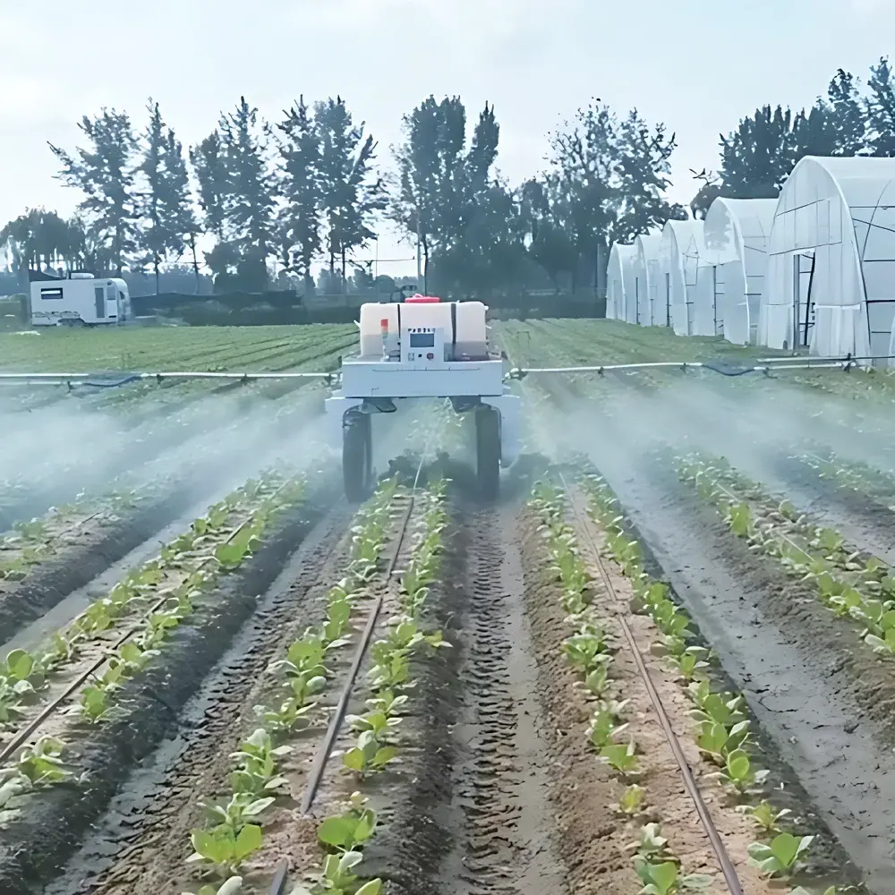
ZWIN-ROBOT-04 Agricultural Precision Spraying Robot
| Brand | ZWINSoft |
|---|---|
| Origin | Tianjin, China |
| Manufacturer Type | Original Equipment Manufacturer (OEM) |
| Country of Manufacture | China |
| Model | ZWIN-ROBOT-04 |
| Pricing | Available Upon Request |
Overview
The ZWIN-ROBOT-04 Agricultural Precision Spraying Robot is an autonomous field robotics platform engineered for high-efficiency, data-driven crop protection in modern precision agriculture. Unlike conventional boom sprayers or manual backpack units, this system operates on a closed-loop perception–decision–actuation architecture grounded in real-time environmental sensing and spatial intelligence. It employs simultaneous localization and mapping (SLAM) fused with RTK-GNSS positioning to achieve centimeter-level navigation accuracy (<±2 cm horizontal, <±5 cm vertical under open-sky conditions). Its core operational principle integrates multi-modal sensor fusion—specifically 3D LiDAR (16-channel, 100 m range), multispectral imaging (5-band, 450–900 nm), and high-resolution RGB vision—to construct dynamic 3D canopy models and extract biophysical indicators including NDVI, LAI, and chlorophyll index. These inputs feed deterministic and probabilistic machine learning models trained on annotated agricultural datasets, enabling pixel-level classification of plant species, phenological stage (e.g., BBCH scale), and biotic stress signatures (e.g., fungal lesions, aphid infestation patterns). The robot then executes variable-rate application (VRA) by modulating nozzle flow rate, spray height, and travel speed in real time—ensuring active ingredient deposition is spatially aligned with detected target zones while minimizing off-target drift and soil runoff.
Key Features
- Autonomous navigation on unstructured terrain: Supports slope operation up to 25°, orchard row tracking via stereo vision + LiDAR edge detection, and adaptive path replanning at ≤100 ms latency.
- Multi-sensor perception stack: Integrated 16-line rotating LiDAR (IP67 rated), 5-band multispectral camera (1280×960 resolution, ±1.5 nm band tolerance), and 4K RGB camera with global shutter and auto-exposure compensation for varying illumination.
- Variable-rate spraying system: Equipped with 8 independently controlled electromagnetic nozzles (0.3–2.0 L/min per nozzle), pressure-regulated pump (0–4.5 bar), and real-time droplet size monitoring via laser diffraction sensor (ISO 25358 compliant).
- Onboard AI inference engine: NVIDIA Jetson AGX Orin module (32 TOPS INT8) running optimized PyTorch models for edge-based inference; model update via secure OTA protocol with cryptographic signature verification.
- Ruggedized mechanical design: IP65 ingress protection, corrosion-resistant aluminum alloy chassis, modular battery system (dual 48 V / 100 Ah LiFePO₄, hot-swappable, >8 h field runtime).
Sample Compatibility & Compliance
The ZWIN-ROBOT-04 is validated for use across major arable and horticultural crops—including maize, wheat, soybean, cotton, apple, pear, and grapevine—under both open-field and high-wire greenhouse configurations. It complies with ISO 16122-1:2021 (Agricultural machinery — Sprayers — Performance requirements and testing), ISO 22867:2020 (Safety requirements for self-propelled sprayers), and EN 13732:2012+A1:2017 (Electromagnetic compatibility of agricultural equipment). All firmware and control logic adhere to IEC 61508 SIL2 functional safety standards. Data handling conforms to GDPR principles for field-level geospatial metadata, and the system supports audit-ready logging required under EU Regulation (EC) No 1107/2009 and US EPA Pesticide Registration Notice 2022-1 for digital application records.
Software & Data Management
The robot interfaces with ZWIN AgriCloud—a secure, ISO/IEC 27001-certified SaaS platform accessible via web browser or native iOS/Android applications. Field mission planning is performed using GIS-integrated tools supporting Shapefile, GeoJSON, and FarmOS-compatible formats. All sensor logs, spray maps, and AI inference outputs are timestamped, georeferenced, and stored with SHA-256 hash integrity verification. The platform provides GLP-compliant electronic records with immutable audit trails, user role-based access control (RBAC), and 21 CFR Part 11–ready e-signature support for regulatory documentation. Raw imagery and point cloud data can be exported in standard formats (TIFF, LAS, CSV) for third-party analysis in QGIS, ArcGIS, or MATLAB environments.
Applications
- Targeted fungicide/insecticide application in vineyards and orchards, reducing chemical load by 20–40% compared to broadcast methods while maintaining disease control efficacy (validated in field trials per EPPO PP1/272(1) protocols).
- Pre- and post-emergence herbicide spot treatment in row crops, minimizing non-target vegetation impact and supporting conservation tillage systems.
- Micro-nutrient and bio-stimulant delivery during critical growth stages (e.g., flowering, grain filling), synchronized with canopy spectral response trends.
- Regulatory compliance reporting for integrated pest management (IPM) programs mandated under national action plans (NAPs) aligned with the EU Sustainable Use Directive (2009/128/EC).
- Longitudinal crop health monitoring: Time-series NDVI and thermal anomaly detection enable early stress identification and yield forecasting integration with farm management information systems (FMIS).
FAQ
Does the ZWIN-ROBOT-04 require GPS base station infrastructure for operation?
No—it operates autonomously using dual-frequency RTK-GNSS receivers compatible with free SBAS corrections (e.g., EGNOS, WAAS) and optionally integrates with local CORS networks for enhanced accuracy.
Can existing farm management software integrate with the ZWIN AgriCloud platform?
Yes—via documented RESTful API endpoints supporting FARM-DATA, ADAPT, and ISO 11783-10 (TC184/SC18/WG10) message schemas for seamless interoperability with John Deere Operations Center, Climate FieldView, and Trimble Ag Software.
What maintenance intervals are recommended for the LiDAR and multispectral sensors?
LiDAR window cleaning every 40 operational hours; multispectral lens calibration annually or after 200 flight hours—both procedures supported by onboard diagnostic routines and guided service workflows in the operator app.
Is the system certified for organic farming use?
While the hardware itself carries no organic certification, its VRA capability enables strict adherence to NOP (USDA) and EC 2092/91 standards by eliminating off-target drift and ensuring only approved substances are applied at verified rates and locations—documentation generated meets certifier audit requirements.
How is cybersecurity ensured for remote fleet management?
All communications use TLS 1.3 encryption; device authentication relies on X.509 certificates provisioned at factory; firmware updates undergo signed package verification; and network traffic is segmented via VLAN isolation in enterprise deployments.