LANENDE LD-JSD-3 Smart Soil Penetrometer
| Brand | LANENDE |
|---|---|
| Origin | Shandong, China |
| Manufacturer Type | Direct Manufacturer |
| Country of Origin | Domestic (China) |
| Model | LD-JSD-3 Smart |
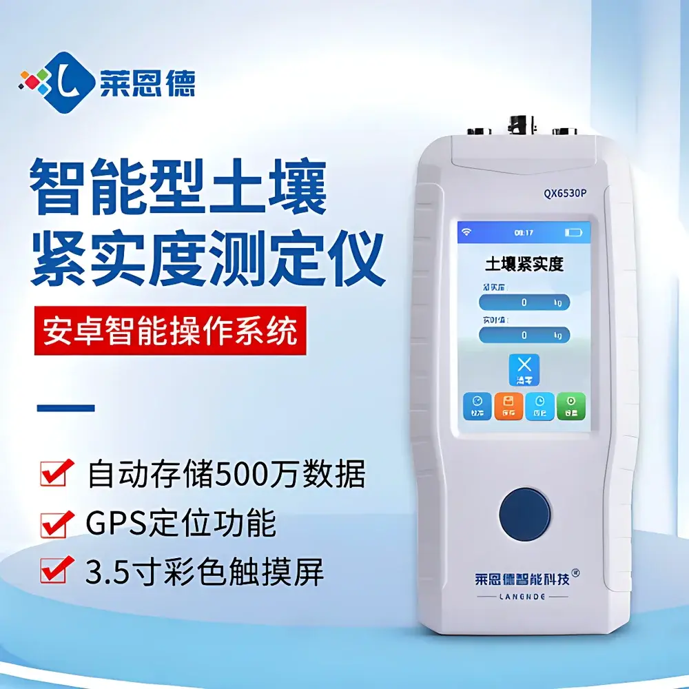
| Instrument Type | Handheld |
| Measurement Accuracy | ±0.1 %F·S |
| Operating Temperature Range | 0–40 °C |
| Processor Architecture | ARM Cortex-M3 |
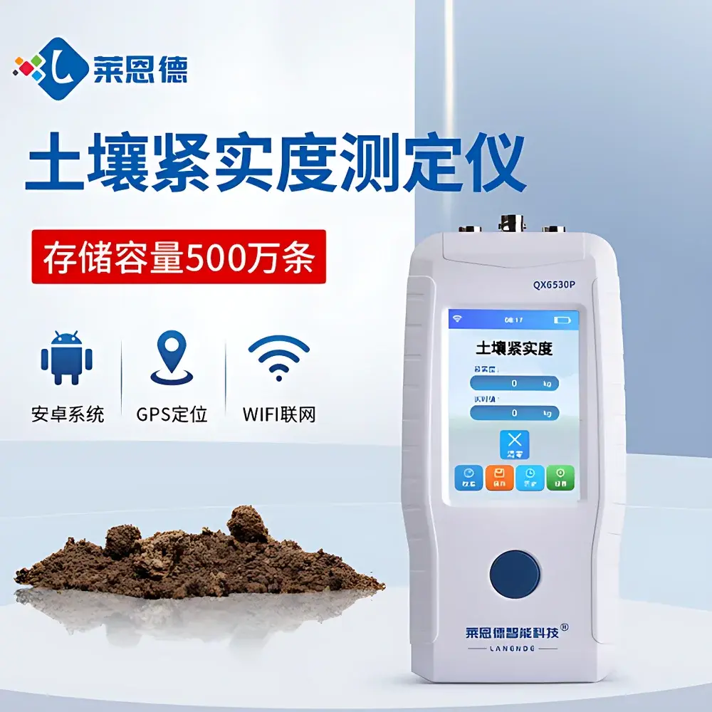
| Operating System | Android-based firmware |
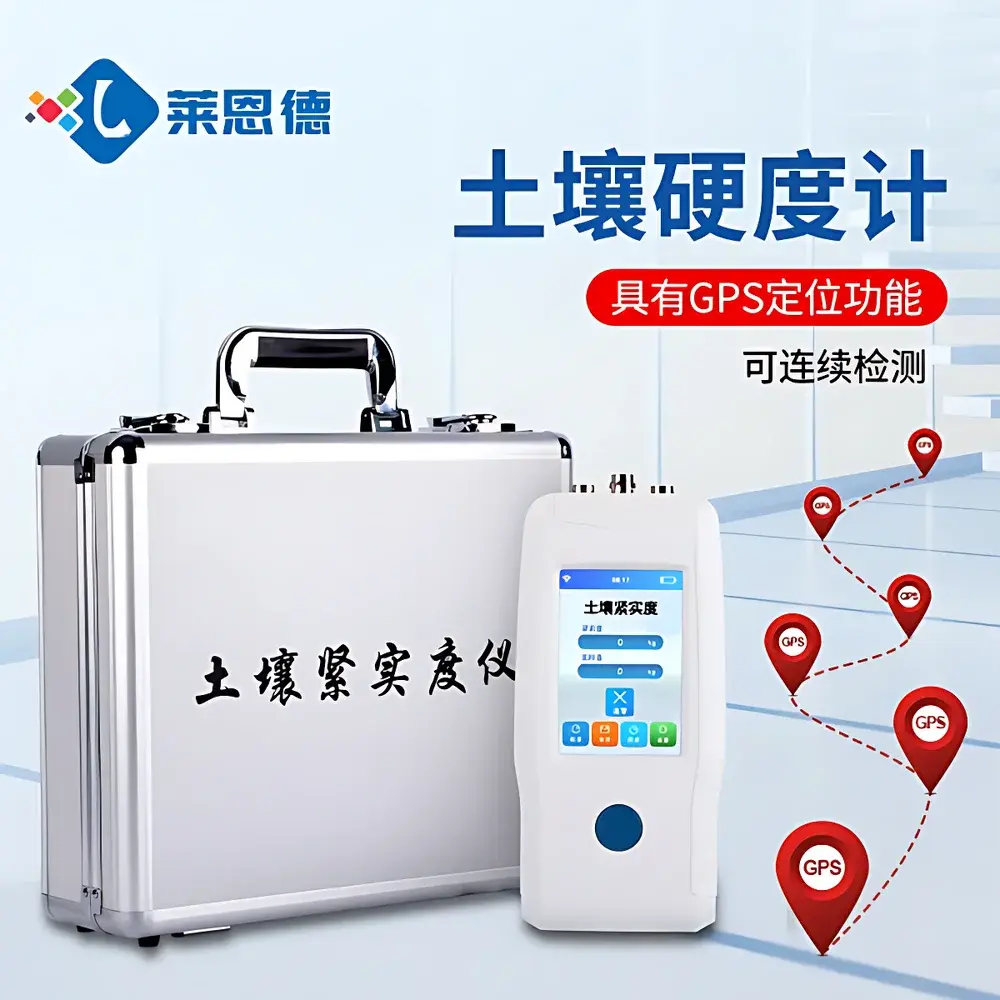
| Connectivity | Wi-Fi, GPS, GPRS (optional), USB-C interface |
| Display | 3.5-inch color touchscreen |
| Data Storage Capacity | Up to 5 million records |
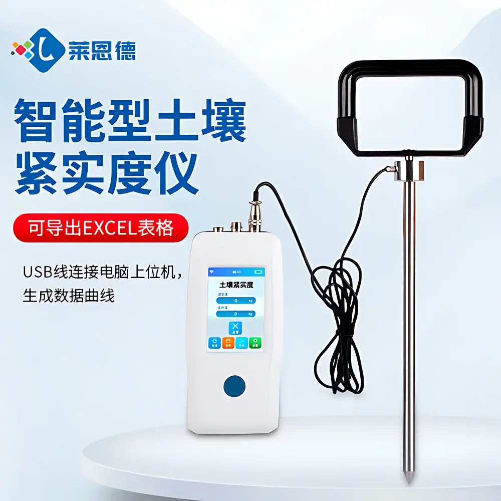
| Data Export Format | CSV/Excel-compatible |
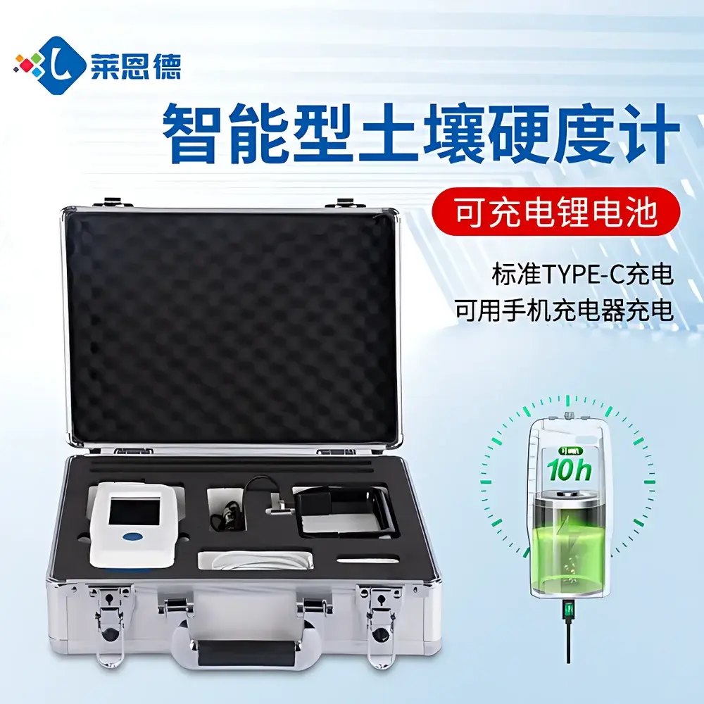
| Power Interface | Standard USB-C charging |
| Sensor Output | Real-time penetrometer force (N) and depth (mm) |
Overview
The LANENDE LD-JSD-3 Smart Soil Penetrometer is a field-deployable, handheld soil compaction measurement instrument engineered for quantitative assessment of soil mechanical resistance—commonly referred to as soil penetration resistance or soil firmness. It operates on the principle of controlled vertical probe insertion at standardized rates (typically 10–20 mm/s), measuring the axial force (in newtons) required to advance a calibrated cylindrical or conical tip into undisturbed soil at defined depths (e.g., 0–600 mm). This force-depth profile directly correlates with soil bulk density, moisture content, structural stability, and root growth impedance—parameters critical in agronomic management, land rehabilitation, and environmental impact assessments. Unlike qualitative manual methods (e.g., hand-augering or thumb pressure tests), the LD-JSD-3 delivers traceable, repeatable, and digitally archived measurements compliant with ASTM D5321 (Standard Test Method for Determining the Angle of Repose of Soils) and ISO 21797:2021 (Soil quality — Determination of soil penetration resistance using a penetrometer). Its integrated design eliminates external data loggers, enabling real-time acquisition without post-field calibration drift.
Key Features
- ARM Cortex-M3 microcontroller platform ensuring deterministic response time and low-power operation during extended field sessions.
- Android-based embedded firmware supporting intuitive touch navigation, multi-language UI (English pre-configured), and over-the-air firmware updates via Wi-Fi.
- USB-C universal charging interface compatible with standard 5 V/2 A mobile chargers—enabling rapid recharge (<2.5 h) and interoperability across global power ecosystems.
- High-resolution 3.5-inch capacitive touchscreen with sunlight-readable brightness (≥450 cd/m²) and glove-compatible touch sensitivity.
- Onboard GPS module (UBLOX NEO-M8N) providing sub-3-meter horizontal accuracy under open-sky conditions; coordinates automatically stamped to each measurement record.
- Dual-mode wireless telemetry: optional GPRS module enables direct transmission to cloud-based agricultural monitoring platforms; Wi-Fi mode supports local network upload to institutional servers or FTP endpoints.
- Robust mechanical housing rated IP65 for dust ingress protection and water jet resistance—suitable for prolonged use in humid, muddy, or dusty field environments.
Sample Compatibility & Compliance
The LD-JSD-3 is validated for use across mineral soils (sandy loam to clay), organic topsoils, and compacted subsoil layers. Probe tip geometry (standard 1.27 cm diameter cone, 30° apex angle per ASAE S313.3) ensures compatibility with international penetrometer databases and comparative studies. All electronic subsystems comply with CE EMC Directive 2014/30/EU and RoHS 2011/65/EU. Data integrity adheres to GLP-aligned practices: each record includes timestamp (RTC-backed), GPS coordinates, sensor ID, operator ID (configurable), and checksum-verified metadata. Optional audit-trail logging satisfies internal QA requirements for regulatory reporting frameworks including USDA-NRCS Technical Note 19 and EU Soil Thematic Strategy monitoring protocols.
Software & Data Management
Measurements are stored locally in non-volatile flash memory (5 million record capacity, ~128 MB) with automatic rollover and cyclic overwrite protection. Data export is supported via USB-C mass storage mode—no proprietary drivers required. Files are generated in UTF-8 encoded CSV format with headers: “Timestamp_UTC”, “Latitude_DD”, “Longitude_DD”, “Depth_mm”, “Force_N”, “Battery_V”, “Temperature_C”. Batch export tools (Windows/macOS/Linux) enable filtering by date range, geofence, or force-threshold criteria. Integration with third-party GIS platforms (QGIS, ArcGIS Pro) is facilitated through WKT geometry generation and ESRI Shapefile conversion utilities included in the free desktop companion software suite.
Applications
- Agronomic zone mapping: Identifying spatial variability in compaction to guide variable-rate tillage or subsoiling interventions.
- Irrigation scheduling support: Correlating penetration resistance profiles with soil water potential thresholds to optimize deficit irrigation strategies.
- Construction site compliance: Verifying post-compaction density of engineered fills prior to pavement or foundation placement per ASTM D698/D1557.
- Ecological restoration monitoring: Tracking long-term changes in soil structure recovery following reforestation or wetland reestablishment projects.
- Educational fieldwork: Providing undergraduate soil science students with hands-on exposure to quantitative pedology instrumentation and data interpretation workflows.
FAQ
What soil types can the LD-JSD-3 reliably measure?
It is validated for mineral soils ranging from coarse sand to heavy clay, as well as organic-rich topsoils with <30% OM content. Performance in saturated peat or rocky gravels requires manual probe stabilization and depth-limited operation.
Is calibration traceable to national standards?
Yes—each unit ships with a NIST-traceable calibration certificate covering the full 0–1000 N force range, verified annually using dead-weight testing rigs per ISO/IEC 17025 accredited procedures.
Can data be synchronized with existing farm management software?
Native API integration is available for AgLeader SMS, Climate FieldView, and Granular via HTTPS POST endpoints; custom middleware development support is provided under LANENDE’s OEM partnership program.
What is the battery life under continuous operation?
With GPS + Wi-Fi enabled, average runtime is 12.5 hours at 25 °C; power consumption drops to ≤120 mW in sleep mode with motion-triggered wake-up.
Does the device meet FDA or EPA regulatory requirements for environmental monitoring?
While not an FDA-regulated medical device, its measurement methodology and documentation practices align with EPA Region 10’s Soil Monitoring Guidance (2022) and are routinely accepted in CERCLA Phase I ESA reports when operated under documented SOPs.
Related Products


