YSI Data Buoy System
| Brand | Xylem |
|---|---|
| Origin | USA |
| Model | YSI Data Buoy |
| Certification | Imported |
| Distribution Type | Authorized Distributor |
| Pricing | Available Upon Request |
Overview
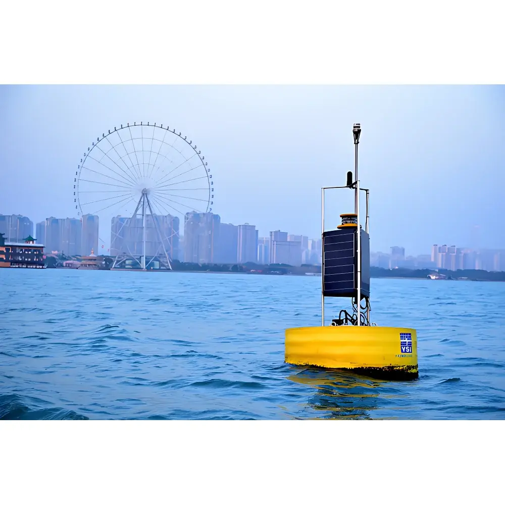
The YSI Data Buoy System is a fully integrated, autonomous environmental monitoring platform engineered for long-term, unattended deployment in marine, estuarine, and freshwater environments. Built upon Xylem’s legacy of precision water quality instrumentation, the system operates on the principle of real-time, multi-parameter in-situ sensing combined with robust telemetry and power management. Its core architecture follows ISO 14001-aligned design principles for environmental monitoring infrastructure and complies with ASTM D5847 (Standard Practice for Quality Systems in Water Analysis Laboratories) for data integrity in field-deployed systems. The buoy serves as a stable, self-contained host for high-accuracy sensors measuring physical, chemical, biological, meteorological, and hydrodynamic parameters—enabling continuous compliance monitoring, ecological trend analysis, and early-warning response for aquatic hazards including harmful algal blooms (HABs), nutrient loading events, and accidental contaminant releases.
Key Features
- High-Performance Buoy Hull: Constructed from yellow ion-exchange polymer foam with optimized buoyancy-to-weight ratio—enabling payload capacities up to 45 kg while maintaining compact footprint and low draft.
- Biofouling-Resistant Surface: Integrated skin layer inhibits macrofouling (e.g., barnacles, mussels) and microbial colonization; validated per ASTM D3648 (Biofouling Resistance Testing).
- Marine-Grade Durability: Flame-retardant, fuel-resistant, and corrosion-immune hull material; withstands mechanical impact, UV exposure, and saltwater immersion per MIL-STD-810G environmental testing protocols.
- Modular Sensor Integration: Standardized mounting rails and IP68-rated wet-mateable connectors support plug-and-play integration of YSI EXO, ProDSS, or third-party sensors—including optical, electrochemical, and acoustic transducers.
- Redundant Power Architecture: Dual-axis solar array (≥120 W peak output) with marine-grade anti-scratch coating and overvoltage protection; paired with maintenance-free deep-cycle AGM batteries (≥10-year service life at 25°C).
- Multi-Protocol Telemetry: Simultaneous support for cellular (CDMA/GSM/LTE-M), Iridium satellite, and VHF/UHF radio transmission; configurable data polling intervals (1 min–24 h) with automatic failover routing.
Sample Compatibility & Compliance
The YSI Data Buoy accommodates sensor suites compliant with EPA Method 1600 (for E. coli), USP (for conductivity), and ISO 5814 (for dissolved oxygen). All onboard electronics meet IEC 60529 IP68 ingress protection and IEC 61000-4 electromagnetic compatibility standards. Data acquisition firmware supports NIST-traceable calibration logging and conforms to FDA 21 CFR Part 11 requirements for electronic records and signatures when deployed under GLP/GMP-regulated programs. GPS positioning accuracy is ≤15 m CEP (Circular Error Probable) per ISO 19115 metadata standards, with geofence-triggered SMS alerts logged with UTC timestamps and audit trails.
Software & Data Management
Data is acquired via YSI’s proprietary EcoWatch™ firmware (v4.2+), which implements embedded SD card storage (up to 32 GB) with cyclic overwrite and CRC-32 error checking. Raw sensor outputs are time-stamped with microsecond resolution and transmitted to YSI HydroSphere™ Cloud—a secure, ISO/IEC 27001-certified SaaS platform offering role-based access control, automated QA/QC flagging (per EPA QA/G-5S), and export-ready CSV/NetCDF formats. API integration supports ingestion into enterprise GIS (ArcGIS Online, QGIS) and SCADA systems (Ignition, Wonderware). Audit logs record all configuration changes, calibration events, and alarm triggers for regulatory review.
Applications
- Real-time compliance monitoring for NPDES and EU WFD (Water Framework Directive) reporting
- Harmful algal bloom (HAB) detection and forecasting using chlorophyll-a, phycocyanin, and PAR profiles
- Nutrient flux modeling at riverine outfalls and aquaculture zones (N:P:Si stoichiometry tracking)
- Stormwater runoff characterization during precipitation events (turbidity spikes, conductivity anomalies)
- Long-term baseline studies for coastal hypoxia, salinity intrusion, and sediment resuspension dynamics
- Calibration validation for remote sensing platforms (e.g., Sentinel-3 OLCI, Landsat 9 OLI-2)
FAQ
What is the maximum deployment depth for mooring configurations?
Standard configurations support depths up to 100 m using galvanized chain or nylon-polyester hybrid moorings; custom deep-water kits (≥500 m) are available with acoustic release modules.
Can the buoy operate through winter ice cover?
Yes—when equipped with optional de-icing heaters and ice-resistant sensor guards, it maintains operation under continuous ice cover per ASTM D7512 ice-load simulation standards.
Is raw sensor data accessible without cloud subscription?
Yes—local retrieval via USB or RS-485 interface provides full-resolution binary data packets compatible with MATLAB, Python (pandas), and R for offline processing.
How frequently does the system perform self-diagnostics?
Continuous hardware health monitoring occurs every 5 minutes; battery voltage, memory usage, sensor warm-up status, and communication link quality are reported with each telemetry cycle.
Related Products


