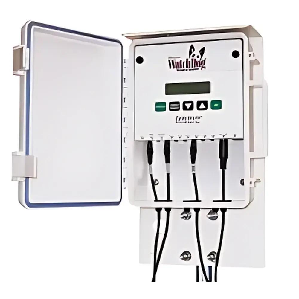
Visualized Soil Moisture Monitoring System Model 2800
| Origin | USA |
|---|---|
| Manufacturer Type | Authorized Distributor |
| Origin Category | Imported |
| Model | 2800 |
| Pricing | Available Upon Request |
Overview
The Visualized Soil Moisture Monitoring System Model 2800 is an integrated, field-deployable environmental monitoring platform engineered for high-fidelity, long-term observation of soil hydrological status and associated crop phenological responses. Built upon a modular architecture, the system combines multi-depth soil hydric-thermal sensing, precision precipitation measurement, time-synchronized digital imaging, and secure IP-based data telemetry. Its core operational principle relies on calibrated dielectric permittivity-based soil moisture sensors (TDR/FDR methodology) coupled with platinum resistance thermometers (PT100-class) for temperature profiling—both validated against ASTM D5734 and ISO 11276 standards for in situ soil water content determination. Designed for unattended operation in remote agricultural or ecological research sites, the Model 2800 delivers synchronized, timestamped datasets that support quantitative analysis of soil water dynamics, root-zone depletion patterns, and plant water stress indices—including early detection of physiological wilting via comparative image analytics.
Key Features
- Multi-layer soil monitoring: Simultaneous acquisition from up to nine sensor channels—configurable across four distinct soil depths or spatial locations—to resolve vertical and lateral moisture/temperature gradients.
- High-resolution environmental sensing: Soil moisture measurement range: 0–saturation (volumetric water content), resolution: 0.1% VWC, accuracy: ±3% VWC (calibrated for mineral soils per USDA NRCS guidelines); soil temperature range: –32°C to +100°C, resolution: 0.1°C, accuracy: ±0.5°C (traceable to NIST SRM 1750).
- Precision rain gauge: Tipping-bucket design with 0.25 mm resolution and ±2% volumetric accuracy over 0–200 mm/hr intensity range; conforms to WMO Guide to Meteorological Instruments and Methods of Observation (CIMO Guide), Chapter 9.
- Programmable imaging module: Field-configurable capture intervals (e.g., hourly/diurnal cycles); 5 MP global-shutter CMOS sensor with fixed-focus lens optimized for 2–10 m field-of-view; supports JPEG compression and EXIF metadata embedding (including GPS geotagging if external GNSS module is connected).
- Robust wireless telemetry: Dual-mode transmission—Ethernet (RJ45) and cellular LTE-M/NB-IoT (optional SIM-enabled)—with configurable upload intervals; encrypted payload delivery via TLS 1.2 to user-defined IPv4/IPv6 endpoints or cloud-hosted MQTT brokers.
- Onboard data integrity: Internal microSD card (up to 32 GB) with cyclic logging; automatic gap-filling during comms outages; CRC32 checksum validation for all transmitted packets.
Sample Compatibility & Compliance
The Model 2800 is compatible with standard 12V DC power sources (solar-charged battery systems recommended for off-grid deployment) and accepts third-party analog (0–5 V, 4–20 mA) or SDI-12 digital sensors via expansion ports. All embedded sensors comply with IEC 60529 (IP68 ingress protection), and the enclosure meets UL 50E for outdoor environmental enclosures. Data handling workflows align with GLP principles: full audit trail of configuration changes, sensor calibration timestamps, and raw-to-engineered value transformations are retained locally and transmitted alongside primary measurements. The system supports optional FDA 21 CFR Part 11-compliant electronic signature modules for regulated agronomic trials.
Software & Data Management
System configuration and real-time telemetry are managed through Spectrum’s proprietary WebUI (accessible via HTTPS on port 443) or CLI over SSH. Raw sensor data and images are structured in ISO 8601-compliant CSV and JPEG formats, respectively. An open RESTful API enables integration with farm management information systems (FMIS), GIS platforms (e.g., QGIS, ArcGIS), or custom dashboards. Optional Spectrum DataHub subscription provides automated ingestion into time-series databases (InfluxDB), anomaly detection using statistical control charts (X-bar R), and generation of standardized reports compliant with FAO-56 dual-crop coefficient frameworks.
Applications
- Irrigation scheduling optimization using real-time root-zone water balance modeling.
- Long-term soil moisture trend analysis for climate resilience assessment in watershed studies.
- Controlled-environment validation of satellite-derived soil moisture products (e.g., SMAP, Sentinel-1).
- Phenocam-based drought stress phenotyping in breeding programs—correlating pixel-level canopy greenness (GCC) with measured soil matric potential.
- Regulatory monitoring for conservation compliance (e.g., USDA EQIP reporting, EU CAP conditionality checks).
FAQ
What is the maximum supported distance between the central unit and remote sensors?
Standard configurations support up to 100 m of shielded twisted-pair cabling per sensor chain; extended reach (≤300 m) is achievable with RS-485 repeaters and proper grounding.
Can the imaging module operate under low-light conditions?
The base module lacks active illumination; however, optional IR-illuminated variants (Model 2800-IR) are available for nocturnal monitoring with monochrome output.
Is firmware update capability available over-the-air?
Yes—signed firmware updates can be deployed remotely via HTTPS or MQTT, with rollback support and cryptographic signature verification.
Does the system support integration with third-party SCADA platforms?
Yes—Modbus TCP and MQTT v3.1.1 protocols are natively implemented; register maps and topic hierarchies are documented in the OEM Integration Manual (Rev. 4.2).
How is sensor calibration traceability maintained?
Each factory-calibrated sensor ships with a NIST-traceable certificate; field recalibration tools and SOPs are provided for periodic verification per ISO/IEC 17025-accredited laboratories.
Related Products