COMECAUSE IN-G30 Portable Canopy Analyzer System
| Brand | COMECAUSE |
|---|---|
| Origin | Shandong, China |
| Manufacturer Type | Direct Manufacturer |
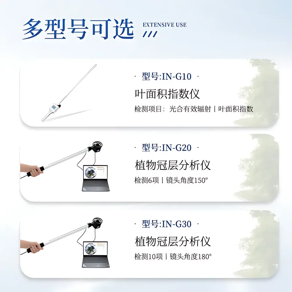
| Model | IN-G30 |
| Principle | Hemispherical Image Analysis (Fisheye Photography) |
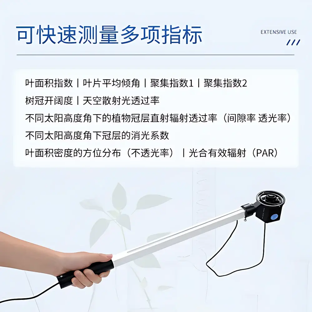
| Type | Portable |
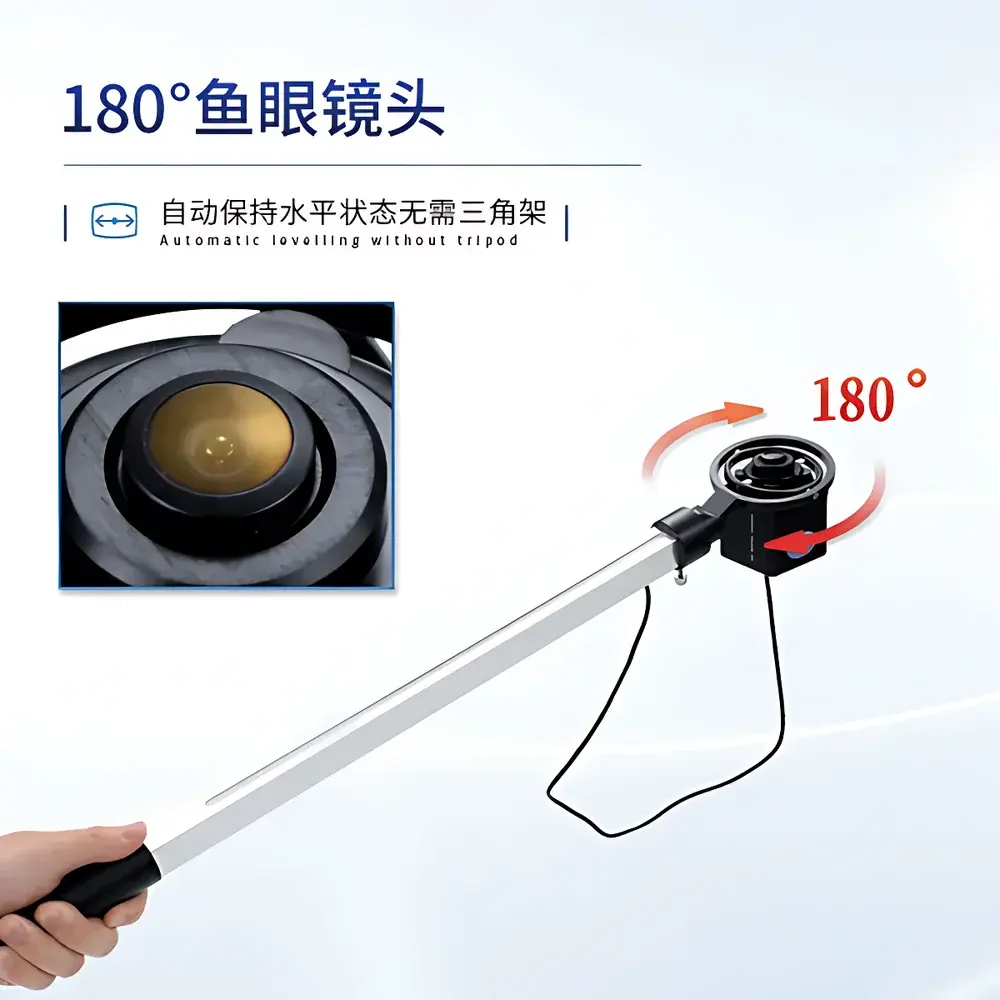
| Lens FOV | 180° |
| Image Resolution | 2592 × 1944 |
| PAR Spectral Range | 400–700 nm |
| PAR Measurement Range | 0–3000 µmol·m⁻²·s⁻¹ |
| Angular Partitioning | Zenith angle 0°–90° (10 zones), Azimuth 0°–360° (10 zones) |
| Operating Temperature | −10°C to +55°C |
| Relative Humidity | ≤85% RH |
| Weight | 500 g |
| Interface | USB |
Overview
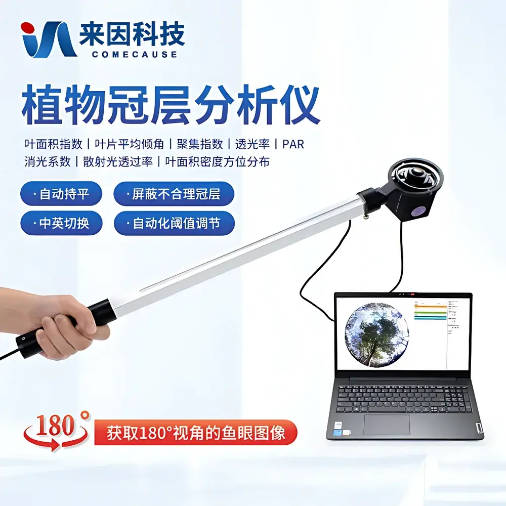
The COMECAUSE IN-G30 Portable Canopy Analyzer System is a field-deployable, fisheye-based hemispherical imaging instrument engineered for quantitative structural and radiative characterization of plant canopies. It operates on the physical principle of gap fraction analysis—leveraging the Beer–Lambert law and validated semi-empirical models that relate sky visibility through canopy gaps to biophysical parameters such as Leaf Area Index (LAI), canopy openness, clumping index, and light extinction coefficients. By capturing upward-looking hemispherical images under natural illumination using a calibrated 180° fisheye lens, the system enables rapid, non-destructive estimation of spatially resolved canopy architecture and radiation transmission dynamics across varying solar zenith and azimuth angles. Designed for ecological monitoring, agronomic optimization, and forest inventory applications, the IN-G30 delivers reproducible, geometry-aware canopy metrics without requiring complex calibration routines or fixed infrastructure.
Key Features
- Integrated 180° fisheye optical probe with auto-leveling gimbal mount—eliminates tripod dependency and ensures consistent image orientation across uneven terrain.
- Modular telescoping measurement arm with integrated 25-point PAR sensor array—enables vertical profiling of photosynthetically active radiation (400–700 nm) and simultaneous acquisition of gap fraction data at multiple canopy heights.
- High-resolution CMOS imaging sensor (2592 × 1944 pixels) optimized for low-noise hemispherical image capture under variable ambient lighting conditions.
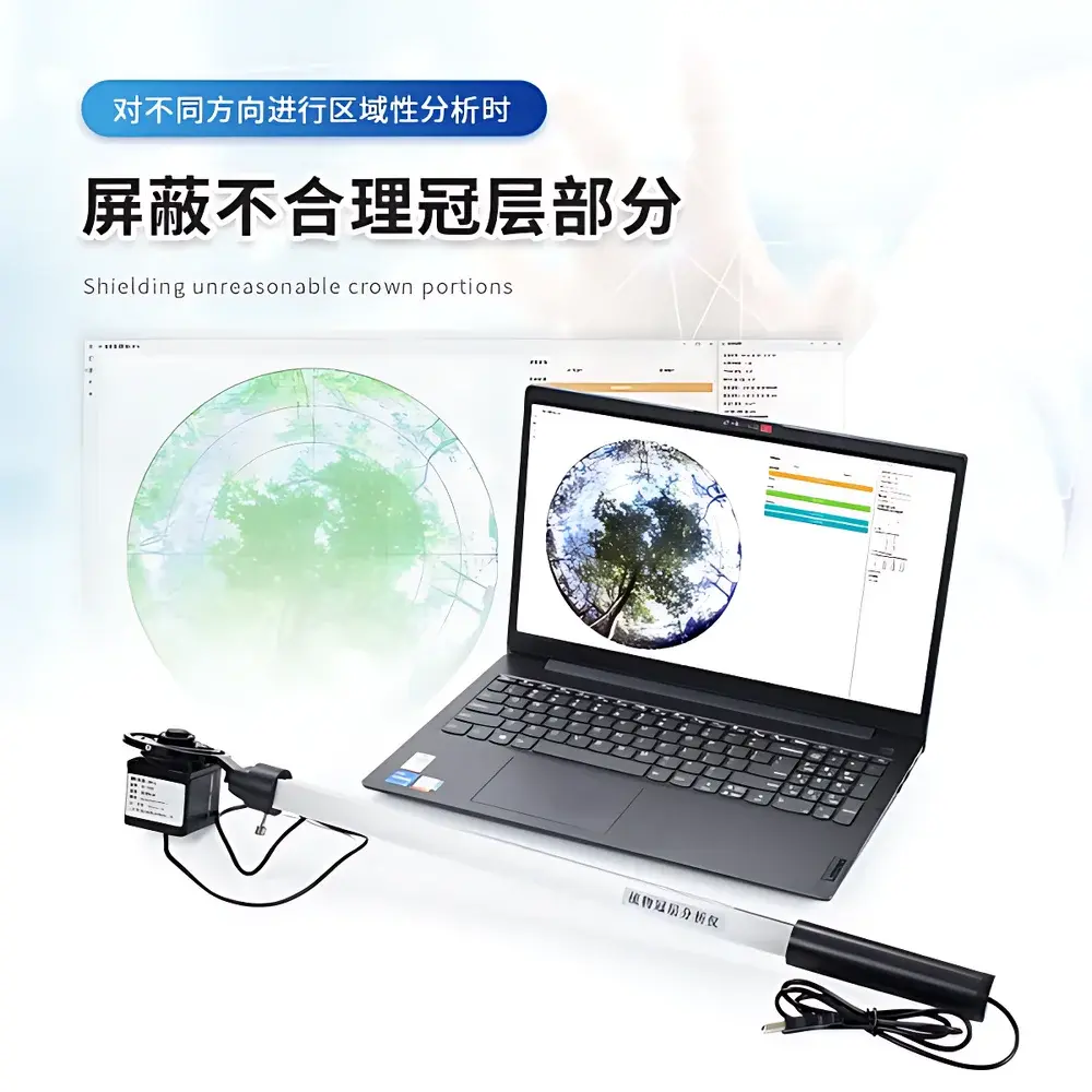
- Configurable angular partitioning: zenith angle segmented into ten 9° intervals (0°–90°), azimuth into ten 36° sectors—supporting directional analysis of canopy heterogeneity and anisotropic light transmission.
- Automated threshold optimization algorithm—minimizes user-induced bias in binary segmentation of sky vs. vegetation pixels, improving inter-operator consistency and measurement repeatability.
- Real-time GPS geotagging (WGS84 coordinates)—ensures traceable spatial metadata for longitudinal studies and GIS-integrated field mapping.
- Bilingual UI (English/Chinese) with one-touch language switching—facilitates multi-regional deployment and collaborative international research.
Sample Compatibility & Compliance
The IN-G30 is compatible with diverse vegetation types—including row crops (maize, soybean), orchards (apple, citrus), agroforestry systems, and natural forest understories—provided sufficient sky visibility exists beneath the canopy. Its non-invasive, optical methodology conforms to ISO 11727:2014 (optical methods for LAI determination) and supports protocols aligned with USDA ARS and FAO crop monitoring frameworks. While not certified to IEC 61000-6-3 or FDA 21 CFR Part 11 out-of-the-box, the system’s raw image and metadata export capabilities (TIFF, CSV, XML) enable full traceability for GLP/GMP-aligned workflows when paired with validated laboratory SOPs and audit-trail documentation.
Software & Data Management
The bundled Canopy Analysis Software Suite provides comprehensive post-processing tools for hemispherical image analysis. Users may define custom regions of interest (ROIs) by zenith and azimuth sector, mask non-canopy artifacts (e.g., soil exposure, edge effects, equipment shadows), and compute over 12 standardized canopy indices—including LAI, mean leaf inclination angle (MLA), gap fraction profiles, direct and diffuse transmittance at discrete solar elevation angles, and azimuthally resolved light extinction coefficients. All outputs are exportable in machine-readable formats (CSV, Excel-compatible XLSX) and support batch processing for time-series analysis. Data synchronization with the COMECAUSE Cloud Agriculture Data Platform is optional and secured via TLS 1.2 encryption; cloud account provisioning follows role-based access control (RBAC) principles compliant with GDPR Article 32 technical safeguards.
Applications
- Optimization of precision irrigation and nitrogen application schedules through spatially explicit LAI and light interception mapping.
- Assessment of canopy closure dynamics during crop phenological stages—supporting early detection of lodging, pest damage, or nutrient stress.
- Validation of radiative transfer models (e.g., SAIL, 4SAIL) used in satellite-derived vegetation index calibration.
- Long-term monitoring of forest structural complexity and successional change in biodiversity hotspots.
- Field validation of UAV-based multispectral canopy reconstruction algorithms.
- Teaching and demonstration of plant–light interaction principles in undergraduate plant physiology and ecosystem ecology curricula.
FAQ
Does the IN-G30 require external power sources in the field?
No—the fisheye probe and measurement arm are powered via USB connection to the included laptop; no batteries or AC adapters are needed for standard operation.
Can the system operate under overcast or low-light conditions?
Yes—its high-sensitivity CMOS sensor and adaptive histogram equalization ensure usable image contrast down to diffuse irradiance levels ≥50 µmol·m⁻²·s⁻¹.
Is raw image data accessible for third-party analysis?
Yes—unprocessed TIFF files, PAR time-series logs, and geotagged metadata are fully exportable without proprietary lock-in.
What is the minimum recommended distance between the fisheye lens and ground surface?
For optimal sky visibility and minimal edge distortion, maintain ≥0.5 m clearance from surrounding vegetation and ≥1.0 m from ground level when measuring closed canopies.
How frequently should the fisheye lens be recalibrated?
Factory calibration is stable for ≥24 months under normal field use; annual verification against a reference gray card and known sky model is recommended for metrological traceability.


