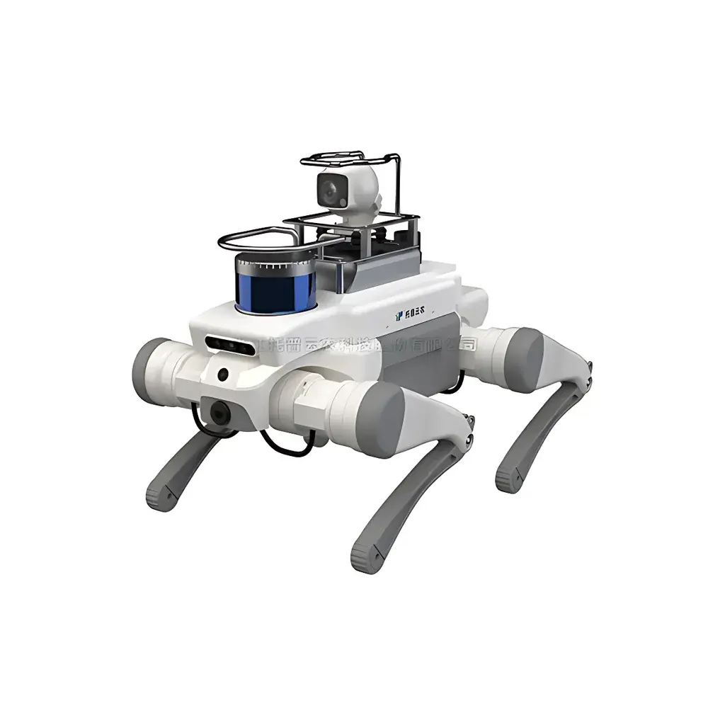
Top Cloud-agri TP-JQG-TJXJ “Wenji” Autonomous Field Scout System
| Brand | Top Cloud-agri |
|---|---|
| Origin | Zhejiang, China |
| Manufacturer Type | Original Equipment Manufacturer (OEM) |
| Country of Origin | China |
| Model | TP-JQG-TJXJ |
| Pricing | Available Upon Request |
Overview
The Top Cloud-agri TP-JQG-TJXJ “Wenji” Autonomous Field Scout System is a purpose-built robotic platform engineered for high-resolution, non-invasive phenotypic monitoring in open-field agricultural environments. It operates on a multi-sensor fusion architecture grounded in autonomous mobile robotics principles—specifically leveraging simultaneous localization and mapping (SLAM), vision-based terrain-aware path planning, and closed-loop navigation under variable GPS-denied or low-accuracy GNSS conditions. At its core lies the “Wenji” intelligent agent—a domain-specific inference engine trained on annotated field imagery and environmental time-series data to execute real-time perceptual reasoning. Unlike stationary or drone-based phenotyping solutions, the TP-JQG-TJXJ system implements ground-level, repeatable, meter-scale spatial sampling with sub-centimeter positional repeatability—enabling longitudinal tracking of individual plant canopies across growth stages. Its measurement paradigm integrates passive optical sensing (visible-spectrum imaging at ≥12 MP resolution, 10-bit dynamic range) with synchronized in-situ microclimate acquisition (air temperature, relative humidity, PAR irradiance, soil surface temperature), establishing a spatiotemporally aligned dataset essential for modeling genotype-by-environment interactions.
Key Features
- Autonomous quadrupedal mobility optimized for uneven terrain, furrowed fields, and crop row navigation without soil compaction or canopy disturbance
- Multi-modal sensor suite: high-fidelity RGB imaging module with adjustable focal length and auto-white balance; integrated environmental sensor array (±0.3°C temp accuracy, ±3% RH, 0–2000 µmol/m²/s PAR)
- Onboard edge AI inference unit supporting real-time execution of convolutional neural networks for pixel-level semantic segmentation and anomaly classification
- Modular software-defined mission framework: pre-programmed patrol routes, adaptive re-scanning of flagged zones, and conditional triggering based on environmental thresholds
- Ruggedized IP67-rated enclosure with extended battery life (>8 hrs continuous operation under mixed workload), thermal management for ambient operation from −10°C to +50°C
- Time-synchronized data logging with UTC-stamped metadata, including GNSS coordinates, IMU orientation, and sensor health diagnostics
Sample Compatibility & Compliance
The TP-JQG-TJXJ system is validated for deployment across staple row crops—including maize, wheat, soybean, rice (paddy-edge compatible), and vegetable varieties such as tomato and cucumber—under both rainfed and irrigated management systems. It supports phenotypic assessment at all vegetative and reproductive stages, from emergence through senescence. Data collection workflows adhere to FAO’s Crop Ontology standards for trait definition and follow ISO 20671:2019 guidelines for field-based phenotyping system validation. All environmental sensor calibrations are traceable to NIM (National Institute of Metrology, China) reference standards. While not certified for regulated GLP/GMP environments, the system’s audit-ready data export format (NetCDF-4 with CF-1.8 conventions) facilitates integration into FAIR-compliant research data management infrastructures.
Software & Data Management
The system operates with Top Cloud-agri’s proprietary FieldScout OS v3.x, featuring a browser-based command console for mission orchestration, firmware updates, and diagnostic telemetry. Raw image streams and sensor time-series are stored locally on encrypted industrial-grade SSDs and automatically synced to secure cloud storage via TLS 1.3–encrypted MQTT protocol. The accompanying PhenomeLink Analytics Suite provides tools for batch annotation, supervised model fine-tuning, and statistical trait extraction—including canopy cover fraction, NDVI-derived vigor indices, fruit count/size distribution histograms, and phenological stage classification (BBCH scale alignment). Export options include CSV, GeoJSON, and MIAPPE-compliant ISA-Tab metadata packages. Audit trails record all user actions, parameter modifications, and algorithm versioning per ISO/IEC 17025:2017 Annex A.2 requirements.
Applications
- Early detection of biotic stress indicators—including chlorosis patterns, necrotic spotting, and abnormal leaf curling—prior to symptom visibility to human scouts
- Quantitative monitoring of canopy architecture dynamics: internode elongation rate, leaf area index (LAI) progression, and tiller/branch count trajectories
- High-throughput validation of drought-tolerant or disease-resistant germplasm in field trials under natural environmental variation
- Calibration and ground-truthing support for satellite- and UAV-based remote sensing models
- Long-term agroecosystem monitoring: correlating microclimatic gradients with yield component formation (e.g., grain set density, pod fill rate)
FAQ
What is the operational range and typical deployment duration per charge?
The system achieves up to 8 hours of continuous operation on a single charge under standard patrol mode (including imaging, navigation, and inference load), covering approximately 15–20 hectares depending on terrain complexity and sampling density.
Does the system require external infrastructure such as base stations or RTK correction signals?
No. It utilizes sensor-fused dead reckoning augmented by visual odometry and sparse feature mapping, enabling reliable navigation in GNSS-challenged zones (e.g., under dense canopy or near treelines). RTK input is optional for georeferencing enhancement but not mandatory for functional autonomy.
Can third-party machine learning models be deployed on the onboard inference engine?
Yes—the edge AI module supports ONNX Runtime execution; users may import custom-trained models compliant with TensorFlow Lite or PyTorch Mobile specifications, provided they meet memory and latency constraints defined in the Hardware Development Kit documentation.
How is data security and privacy managed during cloud synchronization?
All data transmissions employ end-to-end encryption (AES-256 in transit, AES-128 at rest); customer-deployed instances support private cloud or on-premise server configurations with configurable access control lists (ACLs) and role-based permissions aligned with ISO/IEC 27001 Annex A.9.