Top Cloud-agri TP-DGP-JK Autonomous Drone-Based Multispectral Crop Monitoring System with Integrated Hangar
| Brand | Top Cloud-agri |
|---|---|
| Origin | Zhejiang, China |
| Manufacturer Type | OEM Manufacturer |
| Country of Origin | China |
| Model | TP-DGP-JK |
| Pricing | Upon Request |
| Max Horizontal Speed | 21 m/s |
| Max Wind Resistance | 12 m/s |
| Max Flight Time | >40 min |
| Real-time Video Transmission | 1080p/30fps |
| Operating Temperature | −10°C to 40°C |
| Obstacle Sensing | Omnidirectional Dual-Vision System + Downward IR Sensors |
| RTK Accuracy | 1 cm + 1 ppm (horizontal), 1.5 cm + 1 ppm (vertical) |
| Gimbal | 3-Axis Mechanical (Pitch/Roll/Yaw) |
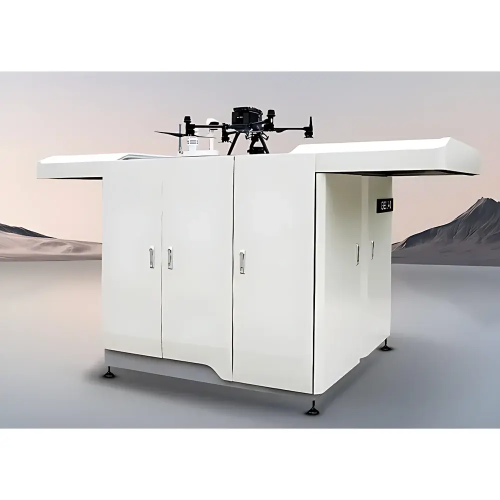
| Hangar Dimensions (Deployed) | 1890 × 800 × 640 mm |
| Hangar Rated Power | 2200 W |
| UPS Backup Duration | ≥1 hour |
Overview
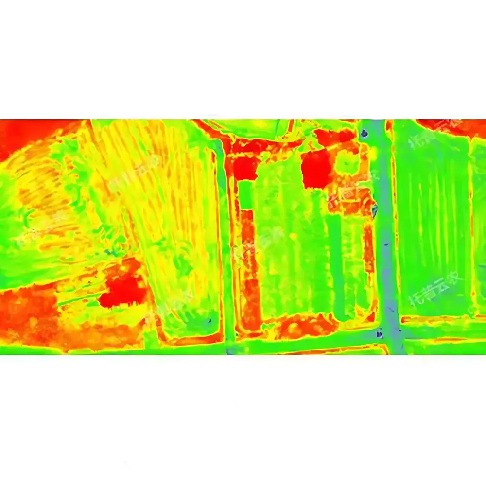
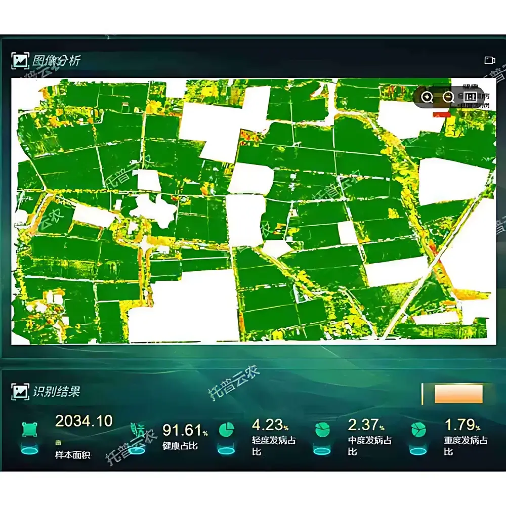
The Top Cloud-agri TP-DGP-JK Autonomous Drone-Based Multispectral Crop Monitoring System with Integrated Hangar is a purpose-built plant phenotyping platform engineered for high-throughput, non-destructive field-scale phenotypic assessment in agricultural research and precision farming operations. Leveraging synchronized visible-light and multispectral imaging—acquired via calibrated spectral bands centered at 550 nm (green), 660 nm (red), 730 nm (red edge), and 850 nm (near-infrared)—the system enables quantitative extraction of biophysically meaningful vegetation indices including NDVI, GNDVI, NDRE, and CIred-edge. These indices serve as robust proxies for chlorophyll content, canopy structure, photosynthetic activity, and water-use efficiency. Unlike manual or tractor-mounted platforms, the TP-DGP-JK integrates an industrial-grade hangar that functions as a fully automated ground station: enabling scheduled takeoff, georeferenced flight path execution, mid-mission battery swap, secure data offloading, and remote diagnostics—all without on-site operator intervention. Designed explicitly for longitudinal monitoring under variable environmental conditions, the system supports repeatable, time-series phenotyping aligned with FAO-recommended crop growth staging protocols and ISO 11120-compliant spectral data acquisition workflows.
Key Features
- Automated mission orchestration: Predefined or dynamic flight plans triggered via cloud API or local scheduler; full autonomy from launch to landing, including battery management and weather-aware rescheduling.
- Dual-sensor payload architecture: 20-MP 4/3″ CMOS visible-light camera (84° FOV) co-registered with a 5-MP 1/2.8″ multispectral sensor array, ensuring pixel-level spatial alignment for robust index computation.
- RTK-enhanced geolocation: Centimeter-level absolute positioning (1 cm + 1 ppm horizontal, 1.5 cm + 1 ppm vertical) ensures sub-meter reproducibility across multi-season campaigns—critical for longitudinal trait mapping and QTL validation studies.
- Real-time telemetry and video streaming: 1080p/30fps low-latency downlink with concurrent transmission of UAV state vectors (altitude, velocity, attitude, battery SOC) and GNSS metadata compliant with NMEA 0183 v4.10.
- Environmental resilience: IP54-rated hangar enclosure with integrated thermal regulation; operational tolerance from −10°C to +40°C; validated performance in wind gusts up to 12 m/s and light precipitation.
- Modular software-defined analytics: Onboard edge inference for rapid anomaly detection (e.g., lodging, stand count deviation); cloud-based batch processing for high-fidelity index derivation, orthomosaic generation, and temporal change analysis.
Sample Compatibility & Compliance
The TP-DGP-JK system is optimized for open-field monocot and dicot crops—including rice, maize, wheat, soybean, cotton, and alfalfa—at vegetative through reproductive growth stages. It accommodates heterogeneous field topographies (slope ≤15°) and supports integration with standard agronomic GIS layers (ESRI Shapefile, GeoJSON). All spectral data outputs adhere to the Plant Phenomics Data Standard (PPDS v2.1) developed by the International Plant Phenotyping Network (IPPN). The platform complies with IEC 62443-3-3 for industrial control system cybersecurity and meets electromagnetic compatibility requirements per EN 61000-6-4. For regulatory traceability, audit logs record all flight events, sensor calibration timestamps, firmware versions, and user actions—supporting GLP-aligned documentation for field trials submitted to national agricultural research councils or OECD TG 511-compliant environmental risk assessments.
Software & Data Management
The system operates via a web-native management platform built on a microservices architecture (Docker/Kubernetes), accessible via role-based authentication (RBAC) over TLS 1.3. Raw imagery and metadata are ingested into a time-series object store (S3-compatible), where they undergo automated radiometric correction using onboard dark-frame and flat-field references. Processed outputs—including NDVI heatmaps, canopy coverage rasters, lodging probability maps, and yield proxy estimates—are exported in GeoTIFF format with embedded EPSG:4326 georeferencing and CF-1.8-compliant NetCDF for interoperability with R/Python-based phenomics pipelines (e.g., phenopype, PlantCV). All analytical models—including CNN-based maize tassel detection and U-Net–driven rice panicle segmentation—are version-controlled, containerized, and validated against benchmark datasets from the Crop Wild Relatives Initiative and the USDA ARS Germplasm Resources Information Network (GRIN). Full compliance with FDA 21 CFR Part 11 is achieved through electronic signature enforcement, immutable audit trails, and configurable retention policies.
Applications
- High-resolution longitudinal phenotyping in breeding nurseries for selection of drought-tolerant, nitrogen-use-efficient, or disease-resistant germplasm.
- Dynamic nutrient status mapping to guide variable-rate fertilization (VRF) in commercial production fields—aligned with ISO 11783-10 (ISOBUS) prescription export standards.
- Early detection of biotic stressors (e.g., Fusarium graminearum in wheat, Xanthomonas oryzae in rice) using red-edge reflectance anomalies prior to symptom onset.
- Quantitative lodging assessment in cereal crops using 3D point-cloud reconstruction from overlapping nadir imagery—enabling yield loss modeling per hectare.
- Field-scale validation of satellite-derived vegetation indices (e.g., Sentinel-2 L2A products) through spatially explicit ground-truthing at 10–30 cm GSD.
- Support for digital twin development in smart farm infrastructure projects, feeding real-time inputs into crop growth simulation models (e.g., APSIM, DSSAT).
FAQ
Does the TP-DGP-JK system support third-party spectral sensors beyond the factory-installed multispectral array?
Yes—via MavLink 2.0–compliant payload interface and standardized CAN bus expansion port; integration requires factory calibration verification and firmware update approval.
How is radiometric consistency maintained across multiple flights and seasonal deployments?
Through automated pre-flight dark-frame capture, onboard irradiance reference panel imaging, and post-processing application of empirical line correction (ELC) using ground control targets distributed across the field.
Can the system operate under partial cloud cover or low-light conditions?
Visible-light imaging is restricted to daylight hours (sun elevation >15°); multispectral acquisition remains viable under diffuse illumination but requires ≥20,000 lux ambient irradiance for optimal SNR in NIR bands.
Is raw sensor data accessible for custom algorithm development?
Yes—unprocessed TIFF stacks with embedded EXIF and XMP metadata (including GPS timestamp, IMU orientation, and spectral band assignment) are available via SFTP or RESTful API.
What level of technical support and calibration services does Top Cloud-agri provide internationally?
Comprehensive remote diagnostics, annual radiometric recalibration (traceable to NIST SRM 2036), and on-site field validation support—available through authorized regional service partners certified to ISO/IEC 17025:2017.


