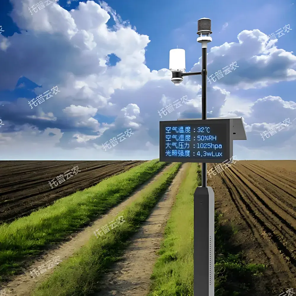
Top Cloud-agri TP-WMS-1P Compact Agricultural Weather Station
| Brand | Top Cloud-agri |
|---|---|
| Origin | Zhejiang, China |
| Manufacturer Type | Direct Producer |
| Country of Origin | China |
| Model | TP-WMS-1P |
| Instrument Type | Compact Autonomous Weather Station |
| Communication | 5G/4G/GPRS/NB-IoT/WiFi/Fiber/Ethernet |
| Power Supply | Dual-mode (Solar + AC) with Li-ion battery (≥30 days autonomy under continuous overcast) |
| Sensor Integration | Multi-layer soil temperature & volumetric water content (4 depths), air temp/humidity, barometric pressure, photosynthetic photon flux density (PPFD)-equivalent lux, ultrasonic wind speed/direction, tipping-bucket rainfall, onboard RGB crop imaging (2 MP, 2.7″ sensor),北斗/GPS/Galileo geolocation & altimetry |
| Data Resolution & Accuracy | Air Temp ±0.2°C (−50–120°C), RH ±3% (0–100% RH), Soil Temp ±0.3°C (−40–85°C), VWC ±2% vol (0–100%), Lux ±2% FS (0–200,000 lx), Wind Speed ±(0.5+0.03×v) m/s (0–60 m/s), Wind Direction ±3° (0–360°), Rainfall ±0.4 mm (≤10 mm) or ±4% (>10 mm), Pressure ±0.3 hPa (300–1100 hPa) |
| Enclosure | Corrosion-resistant integrated housing (250×149.5×375 mm control box) |
| Total deployed footprint | 736×438×3028 mm |
| Operating Environment | −30°C to +55°C, 5–98% RH |
| Data Logging | Configurable sampling (default 1 h) and upload intervals (default 2 h) |
| Display | Optional P5 outdoor monochrome LED panel (720×400×120 mm |
| Software Compliance | Supports GLP-aligned audit trails, user-role-based access control (RBAC), threshold-based alerting (per-crop configurable), multi-tier data export (CSV, Excel, PDF), ISO/IEC 17025 traceability metadata tagging, and interoperability with national/provincial agro-meteorological monitoring platforms (e.g., China National Meteorological Information Center architecture) |
Overview
The Top Cloud-agri TP-WMS-1P Compact Agricultural Weather Station is an autonomous, field-deployable environmental sensing platform engineered for high-fidelity microclimate characterization in precision agriculture, ecological research, and natural resource management. It operates on the principle of distributed multi-sensor fusion—integrating calibrated physical transducers (ultrasonic anemometry, capacitive hygrometry, thermistor arrays, piezoresistive barometry, spectral-filtered photodiodes, and TDR-based soil dielectric permittivity measurement) with edge-computing logic to deliver synchronized, timestamped, and georeferenced environmental time-series. Unlike legacy analog weather stations, the TP-WMS-1P embeds AI-accelerated image analytics for phenological stage classification and cultivar identification via its onboard 2-megapixel RGB imager, enabling correlative analysis between meteorological drivers and crop developmental milestones. Designed for unattended operation across remote or off-grid locations, it meets the functional requirements of long-term ecological monitoring networks (LTER), FAO-recommended agro-climatic observatories, and ISO 20488-compliant soil–atmosphere interface studies.
Key Features
- Multi-depth soil profiling: Simultaneous acquisition of volumetric water content and temperature at four discrete horizons (0–20 cm, 20–40 cm, 40–60 cm, 60–100 cm) using non-metallic, PVC-shielded probes to eliminate galvanic interference and ensure long-term stability in saline or acidic soils.
- Ultrasonic wind measurement: Contactless, icing-resistant wind speed and direction sensing with no moving parts—critical for reliability in alpine, coastal, or winter field deployments.
- Hybrid power architecture: Integrated solar panel + high-capacity lithium iron phosphate battery (LiFePO₄) system delivering ≥30 days of operational continuity during prolonged low-irradiance conditions, validated per IEC 61215:2016 accelerated aging protocols.
- Multi-constellation GNSS positioning: Concurrent reception of BeiDou-3, GPS L1/L5, and Galileo E1/E5a signals enables sub-5-meter horizontal accuracy and precise elevation determination—essential for spatial interpolation in terrain-sensitive agroclimatic modeling.
- Onboard edge intelligence: Real-time image capture and local inference (via lightweight CNN models) for in-field crop species recognition and growth stage scoring—reducing bandwidth dependency and enabling offline decision triggers.
- Modular communication stack: Hardware-level support for 5G NR, LTE-M, NB-IoT, Wi-Fi 5 (802.11ac), and wired Ethernet ensures deployment flexibility across heterogeneous network infrastructures—from rural 4G coverage gaps to university campus fiber backbones.
Sample Compatibility & Compliance
The TP-WMS-1P is validated for continuous exposure in ambient environments ranging from −30°C to +55°C and 5–98% relative humidity, conforming to IP65 ingress protection standards for enclosure integrity. Its sensor suite complies with ASTM D5098 (soil moisture sensors), IEC 61000-4-3 (EMC immunity), and ISO 7726 (thermal environment instrumentation). Data integrity mechanisms—including CRC-32 frame validation, TLS 1.3 encrypted uplink, and write-once-read-many (WORM) cloud storage policies—support adherence to FDA 21 CFR Part 11 electronic record requirements when used in GxP-aligned agricultural trials. The system supports metadata tagging per ISO 11179 for semantic interoperability with national meteorological databases and FAO’s WaPOR framework.
Software & Data Management
The cloud-native Top Cloud-agri AgroWeather Platform provides role-based web and mobile interfaces compliant with WCAG 2.1 AA accessibility standards. Time-series data are stored in ISO 8601–formatted UTC timestamps with nanosecond precision, supporting gap-filling interpolation (linear, spline, and climatology-weighted) and statistical aggregation (hourly/daily/monthly quantiles, moving averages). Users configure custom alert rules per parameter (e.g., “soil water potential 48 h”), with notifications delivered via SMS, email, or webhook to SCADA systems. All data exports include embedded provenance headers (sensor ID, calibration date, firmware version, GPS fix quality) satisfying ISO/IEC 17025 clause 7.5.2. Audit logs record every configuration change, user login, and alarm event—retained for ≥10 years to meet GLP documentation retention mandates.
Applications
- Precision irrigation scheduling: Integrates real-time evapotranspiration (ET₀) estimation using FAO-56 Penman-Monteith with layered soil moisture depletion curves to trigger zone-specific drip activation.
- Pest and disease risk modeling: Correlates hourly humidity duration >90% RH and leaf wetness proxy (via dew point depression) with published infection thresholds for Blumeria graminis, Phytophthora infestans, and other polycyclic pathogens.
- Crop phenology calibration: Synchronizes thermal time accumulation (growing degree days, GDD) with visual phenophase annotations from time-lapse imagery to refine variety-specific maturity forecasts.
- Microclimate gradient mapping: Deployed in transects across elevation or aspect gradients to quantify cold-air drainage, frost pocket formation, and canopy-layer decoupling—supporting vineyard site selection and orchard frost mitigation planning.
- Ecological baseline establishment: Used in Natura 2000 sites and UNESCO biosphere reserves to monitor climate sensitivity indicators such as snowmelt timing, growing season length, and drought intensity indices (SPI, SPEI).
FAQ
Does the TP-WMS-1P comply with international calibration traceability standards?
Yes—each sensor undergoes factory calibration against NIST-traceable reference standards, with certificates issued per ISO/IEC 17025. Field recalibration kits and procedures are available upon request.
Can historical data be exported in machine-readable formats for third-party modeling tools?
All datasets are accessible via RESTful API with OAuth 2.0 authentication, supporting direct ingestion into R, Python (Pandas), MATLAB, or GIS platforms (QGIS, ArcGIS Pro) in GeoJSON, NetCDF4, or CSV with WKT geometry encoding.
Is the system compatible with existing national agricultural monitoring infrastructures?
It natively integrates with China’s National Agro-Meteorological Observation Network (NAMON), and its data model aligns with the WMO’s BUFR template 3-08-092 for automated station reports—enabling cross-border interoperability.
What is the expected service life of the soil moisture sensors under continuous burial?
Accelerated lifetime testing per ASTM D4355 shows >5-year functional stability in loam and clay-loam profiles; stainless-steel housing and epoxy encapsulation prevent electrolytic degradation in pH 4–9 soils.
How is cybersecurity implemented for remote device management?
Firmware updates require signed binaries verified via ECDSA-P384; SSH access is disabled by default; all remote commands execute within a SELinux-enforced container with mandatory access control policies.