Top Cloud-agri TP-BX-2D / TP-BX-2DM / TP-BX-2DMG / TP-BX-2NT Portable Field-Based Plant Phenotyping Imaging System
| Brand | Top Cloud-agri |
|---|---|
| Origin | Zhejiang, China |
| Manufacturer Type | Direct Manufacturer |
| Country of Origin | China |
| Models | TP-BX-2D, TP-BX-2DM, TP-BX-2DMG, TP-BX-2NT |
| Pricing | Upon Request |
| Operating Environment | 0–40 °C, ≤90% RH (non-condensing) |
| Multispectral Unit | 4 narrowband channels + 1 RGB channel, global shutter, multispectral resolution: 1.3 MP, RGB resolution: 8.0 MP |
| Depth Camera Unit | RGB resolution: 8.0 MP |
| Hyperspectral Unit | push-broom imaging, ≥1200 spectral bands, pixel size: 5.86 µm × 5.86 µm, CMOS detector, spatial resolution: ≥1920 × 1920 |
| Thermal Imaging Unit | uncooled microbolometer, temperature range: –20 to +150 °C and 0 to +650 °C (dual-range) |
Overview
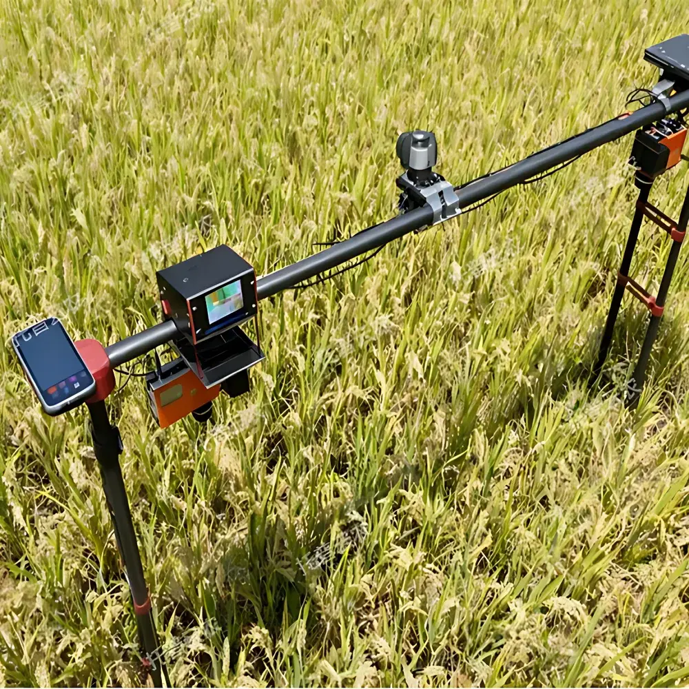
The Top Cloud-agri TP-BX Series is a modular, field-deployable plant phenotyping imaging system engineered for high-fidelity, in situ morphological and physiological trait quantification under real-world agricultural and ecological conditions. Unlike fixed-gantry or greenhouse-based phenotyping platforms, the TP-BX architecture employs a lightweight, telescoping pole framework with aerospace-grade quick-release couplings and foolproof alignment pins—enabling rapid single-operator assembly, disassembly, and transport across heterogeneous terrain. Its core measurement principle integrates multi-modal optical sensing: visible-light imaging captures structural morphology; multispectral imaging enables vegetation index derivation (e.g., NDVI, PRI); hyperspectral push-broom scanning delivers continuous spectral reflectance profiles across the 400–1000 nm range for pigment, water, and nutrient status inference; depth imaging provides 3D canopy structure reconstruction; and calibrated thermal imaging quantifies stomatal conductance proxies via canopy temperature differentials. This sensor fusion approach supports non-destructive, longitudinal monitoring of individual plants or small plots without requiring controlled-environment infrastructure.
Key Features
- Modular Sensor Integration: Interchangeable imaging modules—TP-BX-2D (RGB-only), TP-BX-2DM (multispectral + RGB), TP-BX-2DMG (multispectral + RGB + hyperspectral), and TP-BX-2NT (multispectral + RGB + hyperspectral + thermal)—allow precise configuration matching experimental objectives and budget constraints.
- Field-Optimized Mechanical Design: Carbon-fiber-reinforced aluminum pole system (adjustable height up to 3.5 m), IP54-rated enclosures, and vibration-dampened mounting interfaces ensure operational stability on uneven soil, wind-exposed sites, and variable humidity conditions.
- AI-Powered Trait Extraction: Embedded computer vision pipeline performs automated single-plant segmentation using U-Net-based deep learning models trained on diverse species (e.g., maize, wheat, rice, Arabidopsis). Outputs include emergence rate, projected leaf area, convex hull area, plant height (via stereo triangulation or depth-map regression), RGB chromaticity indices (L*a*b*, HSV), and canopy temperature gradients.
- Environmental Context Synchronization: Optional integrated meteorological sensor suite records ambient temperature, relative humidity, photosynthetically active radiation (PAR), and barometric pressure at 1 Hz sampling—time-stamped and georeferenced to each image capture for environmental covariate analysis.
- Calibration-Traceable Optics: All spectral units undergo factory calibration against NIST-traceable standards; thermal module includes onboard blackbody reference and emissivity correction tools compliant with ASTM E1933-19 for quantitative thermography.
Sample Compatibility & Compliance
The TP-BX platform accommodates herbaceous and semi-woody species ranging from seedlings (≥2 cm height) to mature field crops (up to 2.5 m canopy height). It supports both monocot and dicot architectures, including rosette-forming, tillering, and vine-type growth habits. Data acquisition workflows comply with FAIR principles (Findable, Accessible, Interoperable, Reusable) and are structured to align with MIAPPE v1.1 metadata standards for plant phenotyping experiments. The system’s software architecture supports audit trails, user role-based access control, and export formats compatible with BreedBase, BrAPI, and Crop Ontology—facilitating integration into breeding pipelines governed by GLP or GCP frameworks. While not FDA 21 CFR Part 11-certified out-of-the-box, the data management layer supports optional digital signature and electronic record retention configurations for regulated research environments.
Software & Data Management
The proprietary TopCloud Phenotype Studio (v3.2+) provides a unified interface for device control, image ingestion, batch processing, and trait visualization. Raw sensor data—including radiometrically corrected hyperspectral cubes, georeferenced thermal maps, and point-cloud-derived 3D models—are stored in HDF5 format with embedded EXIF and XMP metadata. Image preprocessing includes flat-field correction, vignetting compensation, and spectral band registration. Trait computation modules are scriptable via Python API (compatible with scikit-image, OpenCV, and PyTorch), enabling custom algorithm deployment. Export options include CSV (trait tables), GeoTIFF (spatial overlays), and JSON-LD (semantic annotation). All processing logs—including timestamp, operator ID, sensor configuration, and environmental context—are archived to support reproducibility audits and ISO/IEC 17025-aligned laboratory quality systems.
Applications
- Field-scale screening of drought, heat, or salinity tolerance in breeding populations
- Early detection of biotic stress (e.g., fungal infection, aphid infestation) via spectral anomaly detection
- Longitudinal monitoring of phenological stages (e.g., heading date, senescence onset) across genotypes
- Canopy architecture modeling for light interception and yield potential estimation
- Validation of remote-sensing algorithms using ground-truthed, high-resolution spectral signatures
- Ecophysiological studies linking stomatal behavior (thermal patterns) with water-use efficiency metrics
FAQ
Is the system suitable for use in rain or high-humidity field conditions?
Yes—the imaging modules and pole electronics meet IP54 ingress protection rating, permitting operation in light rain and ambient humidity up to 90% RH (non-condensing). Extended exposure to heavy precipitation or standing water is not recommended.
Can hyperspectral data be processed without proprietary software?
Yes—raw hyperspectral data is exported in ENVI-compatible BIL format with full wavelength calibration metadata, enabling analysis in open-source tools such as Spectral Python (SPy) or R packages (hyperSpec, pavo).
What level of technical expertise is required for field deployment?
Minimal training is required: assembly/disassembly takes <8 minutes, and image acquisition is guided by touchscreen workflow prompts. Advanced analysis (e.g., custom model training) assumes familiarity with Python and basic computer vision concepts.
Does the system support GPS geotagging of acquired images?
Yes—integrated GNSS receiver (GPS + GLONASS + BeiDou) provides sub-meter horizontal accuracy (SBAS-corrected); coordinates are embedded in image EXIF and synchronized with meteorological timestamps.
Are calibration certificates provided for spectral and thermal sensors?
Each unit ships with factory calibration reports traceable to national metrology institutes; annual recalibration services are available through Top Cloud-agri’s ISO/IEC 17025-accredited service center in Hangzhou.