Top Cloud-agri TNHY Series Handheld Agricultural Environmental Monitoring Station
| Brand | Top Cloud-agri |
|---|---|
| Origin | Zhejiang, China |
| Manufacturer Type | Manufacturer |
| Country of Origin | China |
| Model | TNHY-4G to TNHY-14G |
| Instrument Type | Handheld Weather Station |
| Connectivity | 4G/5G Cellular |
| Data Storage | 30,000 internal Flash entries + expandable microSD (4GB standard) |
| Power | 7.4V 2.8Ah rechargeable Li-ion battery with low-voltage alert |
| GPS | Integrated high-sensitivity module with automatic geotagging |
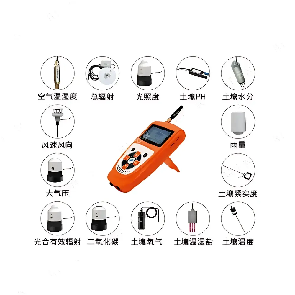
| Sensor Expansion | Up to 32 sensors via IP67-rated daisy-chain hub |
| Compliance | Designed for GLP-aligned field data collection |
Overview
The Top Cloud-agri TNHY Series Handheld Agricultural Environmental Monitoring Station is a modular, field-deployable measurement system engineered for precision agronomic monitoring across diverse cropping systems, orchards, greenhouses, and research trial sites. Unlike fixed-installation weather stations, the TNHY platform employs a portable architecture centered on a ruggedized handheld host unit that communicates wirelessly—via embedded 4G/5G cellular modems—with a secure cloud-based data management infrastructure. Its core operational principle relies on calibrated analog and digital sensor inputs conforming to internationally recognized physical measurement standards: thermistor-based temperature sensing (IEC 60751 Class B), capacitive relative humidity transducers (ISO 7726), silicon photodiode-based lux and PAR (Photosynthetically Active Radiation) detection (CIE S 026/E:2019), TDR (Time Domain Reflectometry) for soil moisture, and electrochemical or NDIR (Non-Dispersive Infrared) methods for CO₂ and soil O₂. Each sensor undergoes factory calibration traceable to national metrology institutes, and all measurements are time-stamped, georeferenced (via integrated GPS), and annotated with sensor-specific metadata—including model number, serial ID, and last calibration date—to ensure data provenance and regulatory readiness.
Key Features
- Modular sensor architecture supporting up to 32 concurrent parameter channels—including air temperature, relative humidity, CO₂ concentration (0–2000 ppm, extendable), photosynthetically active radiation (PAR), total solar radiation, wind speed/direction, tipping-bucket rainfall, soil temperature/moisture/salinity/pH/compaction/O₂—and configurable per application via firmware-selectable sensor profiles.
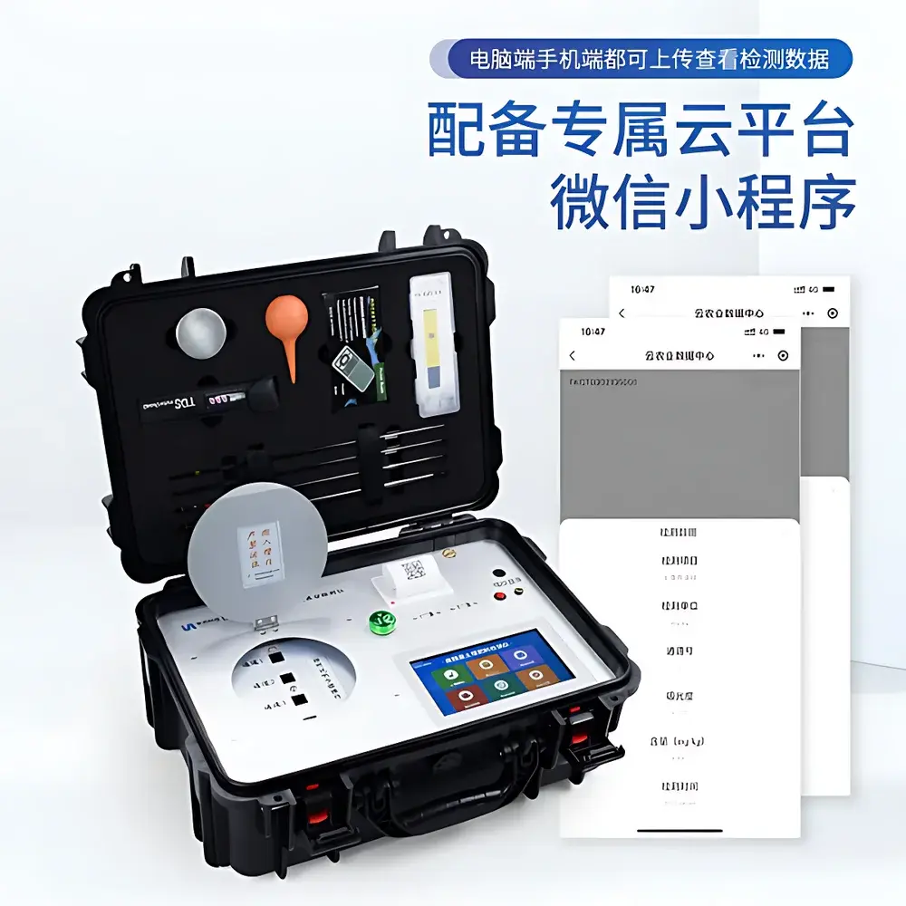
- Real-time 4G/5G telemetry with TLS 1.2 encrypted data transmission to the Top Cloud-agri Instrument Cloud Platform; automatic fallback to local Flash storage (30,000 records) during network outages, with seamless synchronization upon reconnection.
- Integrated GPS receiver providing WGS84 coordinates (±2.5 m CEP) stamped to every measurement packet—enabling spatial interpolation, zone-based analytics, and GIS integration for precision agriculture workflows.
- Low-power embedded design optimized for extended field operation: average current draw <25 mA in sleep mode; battery life up to 7 days under typical 15-minute sampling intervals with active 4G reporting.
- Dual-interface data access: responsive web dashboard (HTML5/CSS3) compatible with desktop and tablet browsers, plus native iOS and Android applications supporting real-time alerts, historical trend visualization, and offline data review.
- Configurable audio feedback: programmable voice prompts for measurement confirmation, threshold exceedance alerts (e.g., “Soil moisture below 15%”), and battery status announcements—critical for hands-free operation in noisy field environments.
Sample Compatibility & Compliance
The TNHY Series is validated for use in uncontrolled outdoor agricultural environments, including high-humidity subtropical zones, arid irrigation districts, and temperate horticultural settings. All sensors meet IP67 ingress protection ratings when connected via the standardized waterproof hub interface. The system supports ISO/IEC 17025-aligned documentation practices through its embedded audit trail: each data record includes UTC timestamp, GPS coordinate, sensor serial number, firmware version, and battery voltage—facilitating traceability required under Good Agricultural Practice (GAP), FAO guidelines, and national extension service protocols. While not FDA 21 CFR Part 11-certified as a standalone device, its data export formats (CSV, JSON, NetCDF) are compatible with validated LIMS and ELN systems used in agronomic research labs operating under GLP conditions.
Software & Data Management
The Top Cloud-agri Instrument Cloud Platform operates on a multi-tenant SaaS architecture hosted on ISO 27001-certified infrastructure. It provides role-based access control (RBAC), automated daily backups, and immutable data logging compliant with ICH-GCP Annex 11 principles. Users can generate time-series plots with adjustable aggregation windows (1-min to 30-day means), perform cross-parameter correlation analysis (e.g., VPD vs. stomatal conductance proxies), and export datasets in machine-readable formats for statistical modeling in R, Python (Pandas), or MATLAB. The platform supports scheduled report generation (PDF/Excel), custom alarm rules (e.g., “Alert if soil temperature >35°C for >2 hours”), and API-driven integration with third-party farm management software (e.g., Climate FieldView™, Granular). Firmware updates are delivered over-the-air with cryptographic signature verification.
Applications
- Irrigation scheduling optimization using real-time soil moisture, evapotranspiration estimates, and atmospheric vapor pressure deficit (VPD) derived from co-located T/RH/CO₂ measurements.
- Phenological monitoring—tracking thermal time accumulation (growing degree days), chilling hour tallies, and light integral exposure for fruit tree dormancy models.
- Controlled-environment agriculture (CEA) validation—verifying HVAC performance, CO₂ enrichment uniformity, and PAR distribution across vertical farming racks.
- Soil health assessment programs measuring spatiotemporal trends in salinity, redox potential (via O₂), and compaction—supporting conservation tillage impact studies.
- Regulatory compliance reporting for water use efficiency (WUE) metrics mandated under regional groundwater sustainability agencies (e.g., SGMA in California).
- Academic field trials requiring georeferenced, timestamped environmental covariates to deconvolve genotype-by-environment interactions (G×E) in crop breeding pipelines.
FAQ
What communication protocols does the TNHY host support?
The device uses LTE-M and NB-IoT-capable 4G/5G modules compliant with 3GPP Release 13/14; no LoRaWAN, Sigfox, or Wi-Fi interfaces are included.
Can sensor calibration certificates be exported from the cloud platform?
Yes—calibration reports (including date, standard used, uncertainty budget, and technician ID) are attached to each sensor’s digital twin profile and downloadable as PDF or XML.
Is offline data logging possible without cellular coverage?
Yes—the host stores raw sensor values with timestamps and GPS coordinates locally in non-volatile Flash memory; data syncs automatically upon network restoration.
How is data security ensured during transmission and storage?
All cellular transmissions use AES-256 encryption and mutual TLS authentication; stored data resides in encrypted object storage with AES-256 server-side encryption and annual penetration testing reports available under NDA.
Does the system support integration with ISO 11783 (ISOBUS) agricultural machinery networks?
No—TNHY is a standalone environmental monitor; ISOBUS integration requires external gateway hardware and custom middleware development.