Top Cloud-agri TPFS-WSY Series Online Soil Moisture, Temperature & Salinity Sensor
| Brand | Top Cloud-agri |
|---|---|
| Origin | Zhejiang, China |
| Manufacturer Type | Direct Manufacturer |
| Product Origin | Domestic (China) |
| Model | TPFS-WSY-1 / TPFS-WSY-2 / TPFS-WSY-3 / TPFS-WSY-4 |
| Power Supply | Solar panel + 220 V AC + built-in 20 Ah / 3.7 V Li-polymer battery |
| Operating Temperature | -20 °C to +70 °C |
| Enclosure Rating | IP67 |
| Data Storage Capacity | ~500,000 records |
| Wireless Communication | Integrated LTE-M/NB-IoT with remote configuration capability |
| GPS Module | Built-in GNSS receiver (GPS/BeiDou) for geotagging |
| Sensor Expansion | Supports up to 32 external analog/digital sensors via standardized interface |
| Alarm Output | Multi-channel notification (LED, voice, mobile push, web dashboard) |
| Data Upload Frequency | Configurable (1 min to 24 h intervals) |
| Flow Management | Shared SIM-based data pool allocation across device fleet |
| Software Platform | TopCloud Agri Instrument Cloud — web and mobile compatible, with audit-trail logging, threshold-based alerting, crop-specific preset profiles, and automated statistical summaries |
Overview
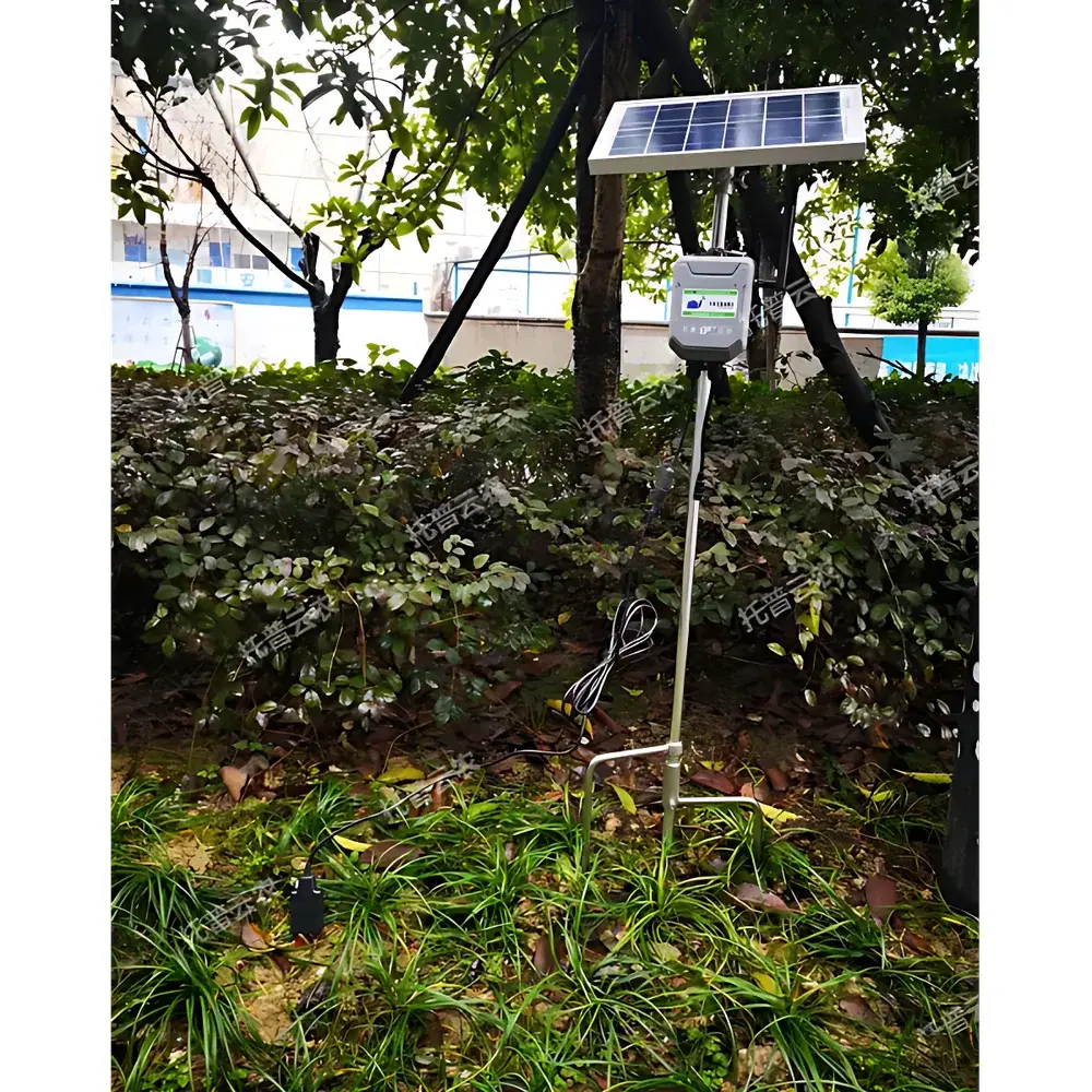
The Top Cloud-agri TPFS-WSY Series is an industrial-grade, field-deployable online monitoring system engineered for continuous, multi-depth measurement of soil moisture content (volumetric water content), temperature, and electrical conductivity (EC)—a proxy for soluble salt concentration. Based on time-domain reflectometry (TDR) and precision thermistor sensing principles, the system delivers high reproducibility in heterogeneous soil matrices under variable climatic conditions. Unlike point-measurement handheld probes, the TPFS-WSY architecture enables stratified profiling across 1 to 4 vertically stacked sensor layers (model-dependent), supporting root-zone monitoring at critical depths (e.g., 10 cm, 20 cm, 40 cm, 60 cm). Its ruggedized IP67-rated housing, wide operating temperature range (-20 °C to +70 °C), and dual-power redundancy (solar + mains + internal 20 Ah Li-polymer battery) ensure uninterrupted operation in unattended agricultural, ecological research, and irrigation management sites—particularly where grid access is unreliable or absent.
Key Features
- Multi-layer soil profiling: Selectable configurations (TPFS-WSY-1 through TPFS-WSY-4) support single- to quad-depth simultaneous acquisition, enabling vertical gradient analysis essential for leaching studies and irrigation scheduling.
- Integrated solar-powered autonomy: Equipped with a certified photovoltaic panel and intelligent charge controller; full battery charge supports ≥200 days of continuous operation without sunlight replenishment.
- Embedded GNSS geolocation: Real-time GPS/BeiDou coordinates are timestamped and embedded into every data packet, facilitating spatial mapping and GIS integration within the TopCloud Agri platform.
- Scalable sensor ecosystem: Standardized analog (0–5 V / 4–20 mA) and digital (RS485 Modbus RTU) interfaces allow seamless integration of auxiliary environmental sensors—including rainfall, leaf wetness, air temperature/humidity, and PAR—up to 32 units per node.
- Regulatory-ready data integrity: All measurements include hardware-timestamped metadata, cryptographic checksums, and optional 21 CFR Part 11-compliant audit trails when deployed in GLP/GMP-aligned agronomic trials.
- Adaptive telemetry management: LTE-M/NB-IoT module supports dynamic APN switching, carrier-fallback logic, and shared data pool allocation across distributed device networks—reducing operational overhead in large-scale deployments.
Sample Compatibility & Compliance
The TPFS-WSY series is validated for use in mineral soils (sand, loam, clay), organic substrates (peat, compost), and hydroponic growing media. Calibration curves are traceable to NIST-certified reference standards for soil moisture (ASTM D5977) and EC (ISO 11265). The device conforms to IEC 60529 (IP67 ingress protection), EN 61000-6-3 (EMC emission limits), and RoHS 2011/65/EU. Firmware and cloud software comply with ISO/IEC 27001 information security controls. For regulated field trials, the system supports user-defined calibration verification protocols and raw-data export in CSV/NetCDF formats compatible with third-party statistical packages (R, Python pandas, SAS).
Software & Data Management
The TopCloud Agri Instrument Cloud platform provides role-based access control (RBAC), RESTful API integration, and TLS 1.2 encrypted data transmission. Users configure alarm thresholds (min/max limits), define crop-specific salinity stress indices (e.g., ECe thresholds for wheat vs. tomato), and generate automated PDF reports compliant with FAO Irrigation and Drainage Paper No. 56. Historical datasets retain full provenance: sensor ID, firmware version, GPS position, battery voltage, signal quality index (SQI), and manual annotation fields. Data retention is indefinite on enterprise-tier subscriptions, with optional cold-archive migration to AWS S3 Glacier for long-term compliance archiving.
Applications
- Precision irrigation scheduling: Real-time root-zone moisture gradients inform dynamic drip emitter control logic, reducing water use by 15–30% in orchard and vineyard trials.
- Salinity monitoring in reclaimed coastal farmland: Continuous EC tracking detects saltwater intrusion fronts and validates leaching efficiency post-irrigation.
- Soil health assessment programs: Long-term moisture-temperature-salinity covariance analysis supports carbon sequestration modeling and microbial activity inference.
- Academic field experiments: Modular depth configuration enables replication of controlled soil column studies across multiple treatment plots with synchronized temporal resolution.
- Smart greenhouse climate-soil coupling: Integration with HVAC and fertigation controllers enables closed-loop nutrient delivery based on substrate EC drift.
FAQ
What is the recommended installation depth for each sensor layer?
Standard deployment follows FAO guidelines: Layer 1 at 10 cm (seed zone), Layer 2 at 20–30 cm (primary root zone), Layer 3 at 40–60 cm (deep percolation monitoring), Layer 4 at 80–100 cm (groundwater interaction zone). Custom spacing is configurable via platform interface.
Can the system operate without cellular coverage?
Yes. Local data logging continues autonomously at user-defined intervals. Once connectivity resumes, buffered records synchronize with time-stamp integrity preserved.
Is sensor recalibration required after prolonged field exposure?
Factory calibration remains stable for ≥24 months under typical agronomic conditions. Field verification using saturated paste extract EC and gravimetric moisture checks is recommended biannually for regulatory-grade studies.
Does the platform support integration with third-party farm management software (FMS)?
Yes. Native connectors exist for Climate FieldView, Granular, and Trimble Ag Software. Generic JSON/XML webhooks and OData v4 endpoints enable custom ERP/MES integrations.
How is data security enforced during wireless transmission?
All payloads are encrypted end-to-end using AES-256-GCM. Device authentication uses X.509 certificates provisioned at manufacturing; no default credentials are shipped.


