Top Cloud-agri TZS-pHWY-7G Multi-Parameter Soil Analyzer
| Brand | Top Cloud-agri |
|---|---|
| Origin | Zhejiang, China |
| Manufacturer Type | OEM/ODM Producer |
| Country of Origin | China |
| Model | TZS-pHWY-7G |
| Instrument Type | Multi-Function Soil Analyzer |
| Wireless Connectivity | 5G/4G Cellular |
| Onboard Storage | 30,000 records (Flash) + 4 GB microSD |
| GPS Integration | Built-in GNSS module (GPS+GLONASS) |
| Power Supply | 7.4 V / 2.8 Ah Li-ion battery (with low-voltage alert & charging protection) |
| Operating Current | 3 mA (standby), variable under active sensing |
| Data Logging Interval | 5 min – 99 h |
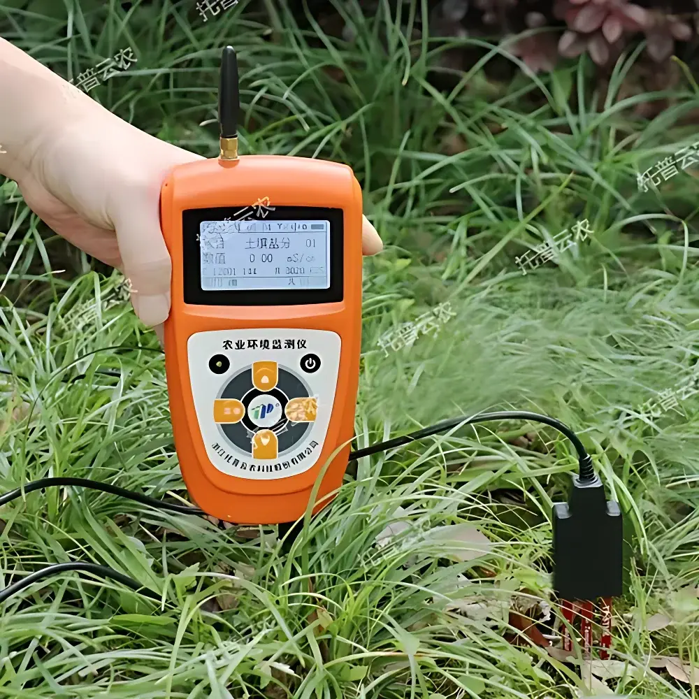
| Display | Backlit Chinese LCD with real-time timestamp, sensor values, storage status |
| Sensor Expansion | Up to 32 channels via IP67-rated daisy-chain hub |
| Environmental Rating | IP67-rated sensor interface |
| Communication Protocols | MQTT/HTTP over cellular |
| Compliance | Designed for field-deployable environmental monitoring per ISO 11277 (soil sampling), ASTM D4972 (pH), ASTM D511 (soluble salts), and USDA-NRCS soil testing guidelines |
Overview
The Top Cloud-agri TZS-pHWY-7G Multi-Parameter Soil Analyzer is a field-deployable, integrated environmental measurement platform engineered for simultaneous in-situ quantification of seven critical soil physicochemical parameters: volumetric water content (VWC), temperature, electrical conductivity (EC), pH, nitrate-nitrogen (N), available phosphorus (P), and exchangeable potassium (K). Unlike single-parameter handheld meters or lab-bound benchtop analyzers, the TZS-pHWY-7G implements a modular sensor architecture grounded in standardized electrochemical, capacitive, thermistor-based, and ion-selective electrode (ISE) transduction principles—enabling direct correlation with widely accepted agronomic and environmental reference methods. Its design targets routine use by extension agents, soil scientists, precision agriculture practitioners, and environmental consultants conducting on-site soil health assessments across heterogeneous landscapes. The system operates independently of laboratory infrastructure, delivering traceable, field-calibrated data aligned with FAO’s Global Soil Laboratory Network (GLOSOLAN) interoperability frameworks.
Key Features
- Integrated multi-sensor fusion architecture supporting concurrent acquisition from up to 32 calibrated probes via an IP67-rated expansion hub—ensuring signal integrity and cross-channel isolation.
- Dual-mode connectivity: Real-time 5G/4G cellular telemetry (MQTT/HTTPS) for live dashboard updates and scheduled offline synchronization via USB-C or microSD card export.
- Onboard dual-storage redundancy: 30,000-row Flash memory buffer + removable 4 GB microSD card—configured for time-stamped, GPS-geotagged records with automatic rollover management.
- Embedded GNSS receiver providing WGS84 coordinates (latitude/longitude/elevation) at each measurement event—essential for spatial interpolation, GIS integration, and compliance reporting.
- Low-power embedded system with adaptive duty cycling: 3 mA standby current and intelligent sleep/wake scheduling for extended unattended operation (up to 12 months depending on logging interval and sensor load).
- Configurable voice feedback in Mandarin Chinese—including threshold-triggered audio alerts for out-of-spec conditions (e.g., pH 4 mS/cm)—supporting hands-free operation in noisy or remote environments.
- Field-serviceable lithium-ion power system (7.4 V / 2.8 Ah) with integrated charge management, voltage monitoring, and visual/audible low-battery warnings.
Sample Compatibility & Compliance
The TZS-pHWY-7G is validated for use with mineral soils (sand, loam, clay), organic-rich topsoils, and amended substrates typical of agricultural, horticultural, and ecological restoration sites. It complies with methodological conventions outlined in ISO 11277 (soil sampling preparation), ASTM D4972 (field pH determination), ASTM D511 (soluble salt extraction and conductivity), and USDA-NRCS Soil Survey Laboratory Methods Manual (SSMLM) Chapter 3 (moisture, EC, pH, NPK extraction protocols). While not certified for GLP or FDA 21 CFR Part 11 environments, its audit-ready data structure—including immutable timestamps, GPS metadata, and sensor calibration identifiers—supports documentation requirements for environmental impact assessments (EIA), land-use planning, and sustainable certification schemes (e.g., Rainforest Alliance, Organic EU Regulation 2018/848).
Software & Data Management
The instrument interfaces natively with the Top Cloud-agri Instrument Cloud Platform—a secure, browser-accessible SaaS environment supporting C/S and B/S deployment models. All data streams are ingested into a relational database schema that preserves raw sensor values, derived indices (e.g., saturation percentage, cation exchange capacity estimates), geospatial context, and device-level diagnostic logs. Users access interactive dashboards featuring temporal trend charts, scatter plots (e.g., EC vs. moisture), heatmaps overlaid on OpenStreetMap basemaps, and customizable PDF report generation. Export formats include CSV, Excel (.xlsx), and XML—compatible with third-party statistical packages (R, Python pandas) and GIS platforms (QGIS, ArcGIS Pro). Firmware and cloud application updates are delivered over-the-air (OTA) without requiring local IT intervention.
Applications
- Precision irrigation scheduling via real-time soil moisture–temperature–salinity coupling to evapotranspiration models.
- Soil fertility mapping for variable-rate fertilizer application (VRT) in row-crop and orchard systems.
- Land degradation monitoring in arid and semi-arid zones, tracking salinization trends using longitudinal EC/pH series.
- Regenerative agriculture program evaluation—quantifying changes in nutrient availability and microbial habitat indicators over multi-season trials.
- Environmental baseline studies prior to construction or mining activities, satisfying regulatory pre-disturbance characterization mandates.
- Educational fieldwork in university soil science curricula, supporting experiential learning in pedology, hydrology, and agroecology.
FAQ
Does the TZS-pHWY-7G require laboratory calibration before field use?
No—each sensor module ships with factory calibration certificates traceable to national metrology institutes. Field recalibration is optional and performed using NIST-traceable standard solutions (e.g., pH 4.01/7.00 buffers, KCl conductivity standards) per included SOPs.
Can sensor modules be replaced individually without affecting system accuracy?
Yes—the modular design allows hot-swapping of individual probes (e.g., replacing only the pH electrode) while retaining full calibration coefficients stored in the host unit’s non-volatile memory.
Is raw sensor output accessible for custom algorithm development?
Yes—CSV exports include unprocessed ADC counts, temperature-compensated values, and sensor-specific metadata fields, enabling reproducible reprocessing in MATLAB or Python.
What is the maximum operational depth for buried sensors?
The standard probe assembly is rated for continuous burial up to 1 m depth in non-aggressive soils; optional stainless-steel armored cables extend this to 2 m in rocky or high-compaction profiles.
How does the system handle data gaps during cellular outages?
All measurements are buffered locally until connectivity resumes; no data loss occurs during intermittent network coverage, and timestamps remain synchronized via onboard RTC with ±2 sec/month drift.


