Top Cloud-agri TP-WMS-1 Agricultural Weather Monitoring System
| Brand | Top Cloud-agri |
|---|---|
| Origin | Zhejiang, China |
| Manufacturer Type | Manufacturer |
| Product Category | Domestic |
| Model | TP-WMS-1 |
| Instrument Type | Autonomous Weather Station |
| Communication | GPRS/NB-IoT/CDMA/4G/5G |
| Sensor Interfaces | RS485 & LoRa |
| Wind Measurement | Ultrasonic (0–65 m/s, 0–360°) |
| Soil Moisture Range | 0–100% (±2% accuracy, 0.1% resolution) |
| Soil Temperature Range | −20–100°C (±0.2°C, 0.1°C res.) |
| Air Temperature | −40–120°C (±0.3°C, 0.1°C res.) |
| Relative Humidity | 0–100% RH (±2%, 0.1% res.) |
| Illuminance | 0–200,000 lux (±2% FS, 1 lux res.) |
| Rainfall | 0–4 mm/min (±0.4 mm ≤10 mm |
| Camera | 1920×1080, 2 MP, 4 mm lens, 89.1° FoV |
Overview
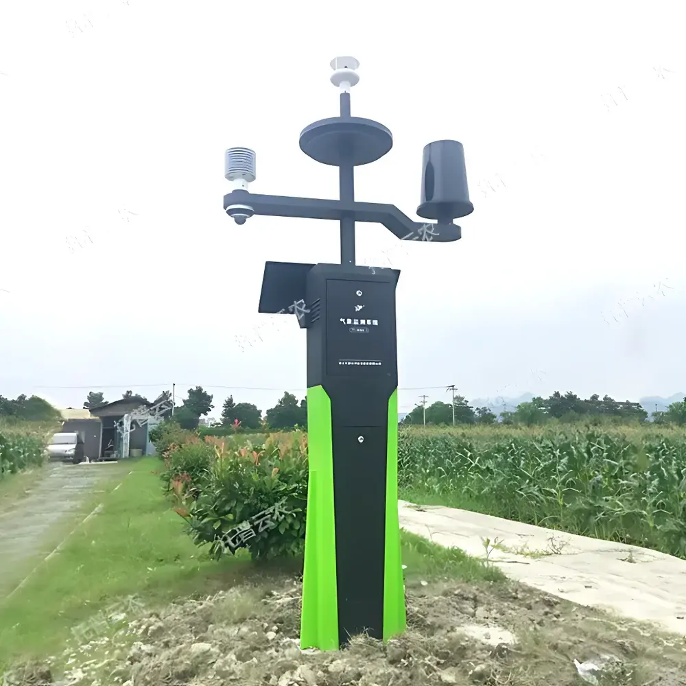
The Top Cloud-agri TP-WMS-1 Agricultural Weather Monitoring System is an autonomous, solar-powered environmental observation platform engineered for continuous, unattended measurement of agro-meteorological parameters in field conditions. It operates on the principle of multi-sensor fusion—integrating physical transduction (capacitive soil moisture sensing, platinum RTD soil/air temperature detection, ultrasonic wind profiling, silicon photodiode irradiance measurement, tipping-bucket rainfall collection) with embedded edge processing and cellular telemetry. Designed specifically for heterogeneous agricultural landscapes—from paddy fields and orchards to grasslands and arid horticultural zones—the system delivers time-synchronized, traceable environmental data streams compliant with national agricultural monitoring infrastructure requirements, including integration with China’s National Crop Pest & Disease Digital Early-Warning System and National Soil Moisture Monitoring Network.
Key Features
- Multi-layer soil monitoring: Simultaneous acquisition of volumetric water content and temperature at four discrete depths (0–20 cm, 20–40 cm, 40–60 cm, 60–100 cm) using non-metallic, corrosion-resistant probes.
- Ultrasonic wind sensing: Zero-threshold anemometry and vane-free wind direction detection (0–65 m/s, 0–360°), eliminating mechanical wear and directional dead zones.
- Integrated high-resolution phenotyping: 2 MP camera (1920×1080) with fixed 4 mm lens and 89.1° horizontal field of view, supporting scheduled image capture, remote pan-tilt control (via cloud-commanded motorized gimbal), and real-time video streaming.
- Dual-mode positioning & altitude sensing: Embedded multi-constellation GNSS receiver (BDS, GPS, Galileo) with automatic elevation calibration and anti-theft displacement/vibration alerts.
- Adaptive communication architecture: Field-configurable network selection across GPRS, NB-IoT, CDMA, LTE Cat-1, and 5G NR, ensuring robust connectivity in low-infrastructure rural deployments.
- Remote device management: Over-the-air firmware updates, sensor recalibration commands,采集 interval reconfiguration, and watchdog-triggered auto-reboot—all executed via encrypted HTTPS API or native mobile application.
- Typhoon-resilient mechanical design: Structural rating equivalent to Beaufort Scale 11 (≥32.7 m/s sustained winds), validated under simulated gust loading per GB/T 2423.10–2019.
Sample Compatibility & Compliance
The TP-WMS-1 is validated for deployment across diverse pedoclimatic regimes—including alluvial, loamy, saline-alkali, and lateritic soils—and accommodates variable canopy architectures (low-stature row crops, trellised vines, open-range pasture). Sensor calibration protocols align with JJF 1182–2018 (National Metrological Verification Regulation for Soil Moisture Sensors) and QX/T 23–2019 (Meteorological Industry Standard for Automatic Weather Stations). Data integrity mechanisms support audit-ready operation under GLP-aligned agricultural research frameworks. While not FDA 21 CFR Part 11-certified (as it is not a clinical or pharmaceutical device), its timestamped, immutable cloud storage architecture enables full traceability required for national agricultural statistical reporting and ecological monitoring programs governed by the Ministry of Agriculture and Rural Affairs (MARA) and China Meteorological Administration (CMA).
Software & Data Management
The system interfaces with Top Cloud-agri’s proprietary AgriCloud Platform—a web-based SaaS environment accessible via desktop browser or iOS/Android app. All measurements are ingested with ISO 8601 timestamps, stored redundantly across geodistributed servers, and retained indefinitely without user-imposed expiration. The platform provides:
- Parameter-specific trend visualization with zoom/pan, statistical overlays (min/max/mean), and comparative multi-node analysis.
- Automated soil moisture profile interpretation: Layered drought stress indexing, root-zone water deficit modeling, and irrigation scheduling recommendations based on FAO-56 crop coefficients.
- Computer vision–assisted phenometrics: CNN-driven canopy coverage estimation, growth stage classification (e.g., BBCH scale alignment), and manual expert annotation workflows.
- Configurable alerting: Threshold-based notifications (SMS/email/app push) for out-of-range values, battery voltage drop (<11.5 V), solar charging failure, or physical tampering.
- Export flexibility: Raw time-series data downloadable in CSV, Excel (.xlsx), and PDF report formats; metadata-rich JSON exports available for third-party GIS or statistical software ingestion.
- Firmware and algorithm updates delivered via signed OTA packages, with rollback capability and versioned changelogs.
Applications
The TP-WMS-1 serves as a foundational node in precision agriculture infrastructure, supporting operational use cases including:
- Dynamic irrigation scheduling through real-time evapotranspiration (ET₀) estimation and root-zone moisture budgeting.
- Early-warning surveillance for abiotic stress (heat/drought/frost) and biotic threats (pest outbreak correlation with microclimatic thresholds).
- Long-term agroecosystem monitoring for carbon sequestration studies, land-use change assessment, and climate adaptation modeling.
- Validation of satellite-derived land surface products (e.g., MOD16 ET, SMAP soil moisture) at field scale.
- Curriculum-integrated teaching tools for agronomy, meteorology, and environmental science programs requiring authentic, high-frequency observational datasets.
- Regulatory compliance reporting for ecological compensation zones, organic certification audits, and watershed management plans.
FAQ
Does the TP-WMS-1 comply with international meteorological standards such as WMO guidelines?
While primarily aligned with Chinese national standards (QX/T series), its measurement methodologies—especially ultrasonic wind profiling and capacitive soil moisture sensing—are functionally consistent with WMO Guide to Instruments and Observing Methods (WMO-No. 8) principles for automated station performance.
Can the system operate independently during extended cloudy periods?
Yes. Equipped with a 30 Ah deep-cycle LiFePO₄ battery and intelligent power management, it sustains ≥14 days of continuous operation without solar recharge under worst-case irradiance conditions (≤50 W/m² average daily insolation).
Is raw sensor data accessible via API for integration into custom farm management software?
Yes. RESTful JSON APIs with OAuth 2.0 authentication are provided for programmatic access to real-time telemetry, historical archives, device status, and image metadata.
How frequently can data be uploaded to the cloud?
Upload intervals are fully configurable from 1 minute to 24 hours per parameter group, with adaptive buffering to prevent data loss during transient network outages.
Are calibration certificates provided with each sensor?
Each soil moisture and temperature probe ships with a factory calibration report traceable to NIM (National Institute of Metrology, China); field recalibration is supported via two-point offset adjustment within the cloud platform.