Top Cloud-agri TPGSQ-4 Tube-Type Soil Moisture and Temperature Profiling Station
| Brand | Top Cloud-agri |
|---|---|
| Origin | Zhejiang, China |
| Manufacturer Type | Manufacturer |
| Country of Origin | Domestic (China) |
| Model | TPGSQ-4 |
| Instrument Type | Soil Moisture and Water Potential Analyzer |
| Soil Moisture Range | 0–100% RH |
| Soil Moisture Accuracy | ±3% (0–50% RH) |
| Soil Temperature Range | −40 °C to +85 °C |
| Soil Temperature Accuracy | ±0.5 °C |
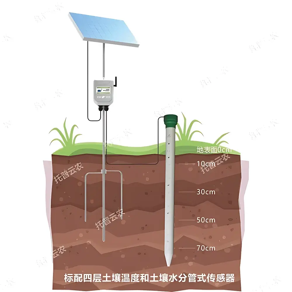
| Maximum Standard Monitoring Depth | 70 cm (customizable beyond 70 cm) |
| Minimum Sensor Spacing | 10 cm |
| Data Logging Interval | 5 minutes to 12 hours |
| Communication Options | 4G/5G cellular & RS485 (≥100 m) |
| Enclosure Rating | IP67 |
| Housing Material | PVC |
| Power Options | Solar panel, AC 220 V, or long-life internal Li-ion battery |
| Integrated Sensors | 4-layer soil moisture & temperature probes |
| Onboard GPS | Yes |
| Vibration Detection | Yes |
| Data Interface | Open API (HTTP/HTTPS) |
Overview
The Top Cloud-agri TPGSQ-4 Tube-Type Soil Moisture and Temperature Profiling Station is an integrated, in-situ environmental monitoring system engineered for continuous, multi-depth soil parameter acquisition in agricultural, ecological, and geotechnical applications. Unlike point-sensor deployments, the TPGSQ-4 employs a vertically installed tubular probe housing co-located dielectric permittivity-based soil moisture sensors and precision thermistors at discrete, user-configurable depths—enabling high-resolution vertical profiling of volumetric water content (VWC) and thermal gradients within the unsaturated zone. Its measurement principle relies on time-domain transmission (TDT) or frequency-domain reflectometry (FDR), calibrated per ISO 11274 and ASTM D5859 standards for field soil moisture quantification. Designed for unattended operation in remote or harsh outdoor environments, the station supports long-term deployment under variable climatic conditions—including frost, heavy rainfall, and UV exposure—without requiring routine maintenance or recalibration.
Key Features
- IP67-rated, fully sealed PVC tube structure ensures operational integrity in saturated soils, flooded fields, or dusty arid zones.
- Modular sensor array with factory-calibrated 4-layer configuration (standard); customizable up to 8 layers with minimum 10 cm inter-sensor spacing and maximum standard depth of 70 cm (extended depth options available upon specification).
- Integrated dual-mode communication: LTE-M/NB-IoT or 5G cellular uplink for real-time data transmission, supplemented by RS485 interface for local wired integration into SCADA or legacy farm management systems.
- Onboard GPS module provides traceable geolocation metadata (latitude, longitude, altitude) synchronized with each data packet—critical for spatial interpolation, GIS mapping, and regulatory reporting.
- Vibration-detection algorithm triggers immediate alert notifications via mobile app or email when unauthorized physical displacement or tampering is detected—enhancing asset security in unmonitored rural deployments.
- Triple power architecture: configurable between solar-charged lithium battery (designed for >2 years autonomy in mid-latitude temperate zones), grid-connected 220 V AC supply, or hybrid operation.
- Low-power embedded microcontroller enables programmable sampling intervals from 5 minutes to 12 hours—optimized for battery life without compromising temporal resolution for irrigation scheduling or drought index modeling.
Sample Compatibility & Compliance
The TPGSQ-4 is validated for use across diverse soil textures—from coarse sands and loams to clay-rich vertisols—and exhibits minimal hysteresis effects across wetting/drying cycles. Sensor calibration accounts for bulk electrical conductivity (EC) influence up to 4 dS/m, supporting reliable performance in saline or fertilized agricultural soils. The system complies with IEC 60529 (IP67 ingress protection), RoHS Directive 2011/65/EU, and CE marking requirements for electromagnetic compatibility (EMC) and low-voltage safety. While not certified for FDA 21 CFR Part 11 or ISO/IEC 17025 laboratory accreditation, its data output structure and timestamping protocol align with GLP-aligned field data collection workflows used in agronomic research, watershed monitoring, and climate-smart agriculture initiatives.
Software & Data Management
The TPGSQ-4 interfaces natively with the vendor-hosted Top Cloud-agri Instrument Cloud Platform—a secure, role-based SaaS environment accessible via web browser or native iOS/Android applications. The platform implements TLS 1.2+ encrypted data ingestion, automatic time synchronization (NTP), and audit-trail logging for all configuration changes and user actions. Raw sensor values are stored with full metadata (GPS coordinates, UTC timestamps, signal strength, battery voltage), enabling traceability and reproducibility. Visualization tools include interactive time-series plots, depth-profile heatmaps, and customizable threshold-based alerts. Data exports support CSV, Excel (.xlsx), and NetCDF formats; API endpoints (RESTful JSON) allow integration with third-party platforms such as FarmOS, AgriWebb, or custom Python/R analytics pipelines. Firmware updates are delivered over-the-air (OTA) with version rollback capability and integrity checksum verification.
Applications
- Drought Early Warning Systems: Continuous profiling supports calculation of root-zone soil water deficit indices and evapotranspiration (ET) model inputs for regional drought severity classification (e.g., USDM criteria).
- Precision Irrigation Management: Real-time moisture gradients inform dynamic drip or pivot scheduling, reducing water use by 15–30% while maintaining yield stability.
- Landslide Risk Assessment: Co-monitored temperature and moisture dynamics near slip planes provide early indicators of pore-pressure buildup in slope stability monitoring networks.
- Crop Phenology Modeling: High-frequency soil thermal inertia data improves estimation of seedbed temperature accumulation (growing degree days) for planting date optimization.
- Soil Carbon Research: Long-term moisture-temperature covariance datasets support modeling of heterotrophic respiration rates in SOC sequestration studies.
FAQ
What is the maximum recommended burial depth for standard TPGSQ-4 installation?
The standard unit is rated for stable operation at up to 70 cm depth; deeper installations (up to 2 m) require reinforced housing and customized cable routing—contact engineering support for site-specific validation.
Can sensor layers be added or repositioned post-installation?
No—sensor positions are fixed during manufacturing. Custom layer configurations must be specified prior to order fulfillment.
Is raw sensor output accessible without using the cloud platform?
Yes. The RS485 interface supports Modbus RTU protocol; register maps and command syntax are provided in the technical documentation for direct integration with PLCs or edge gateways.
How frequently does the GPS location update?
Geolocation is captured once per data transmission cycle (configurable interval) and embedded in each telemetry packet; no continuous GNSS polling to conserve power.
Does the system support external meteorological sensor integration?
The platform accepts third-party sensor data via MQTT or HTTP POST if pre-registered in the device configuration; analog or digital inputs require optional expansion modules.


