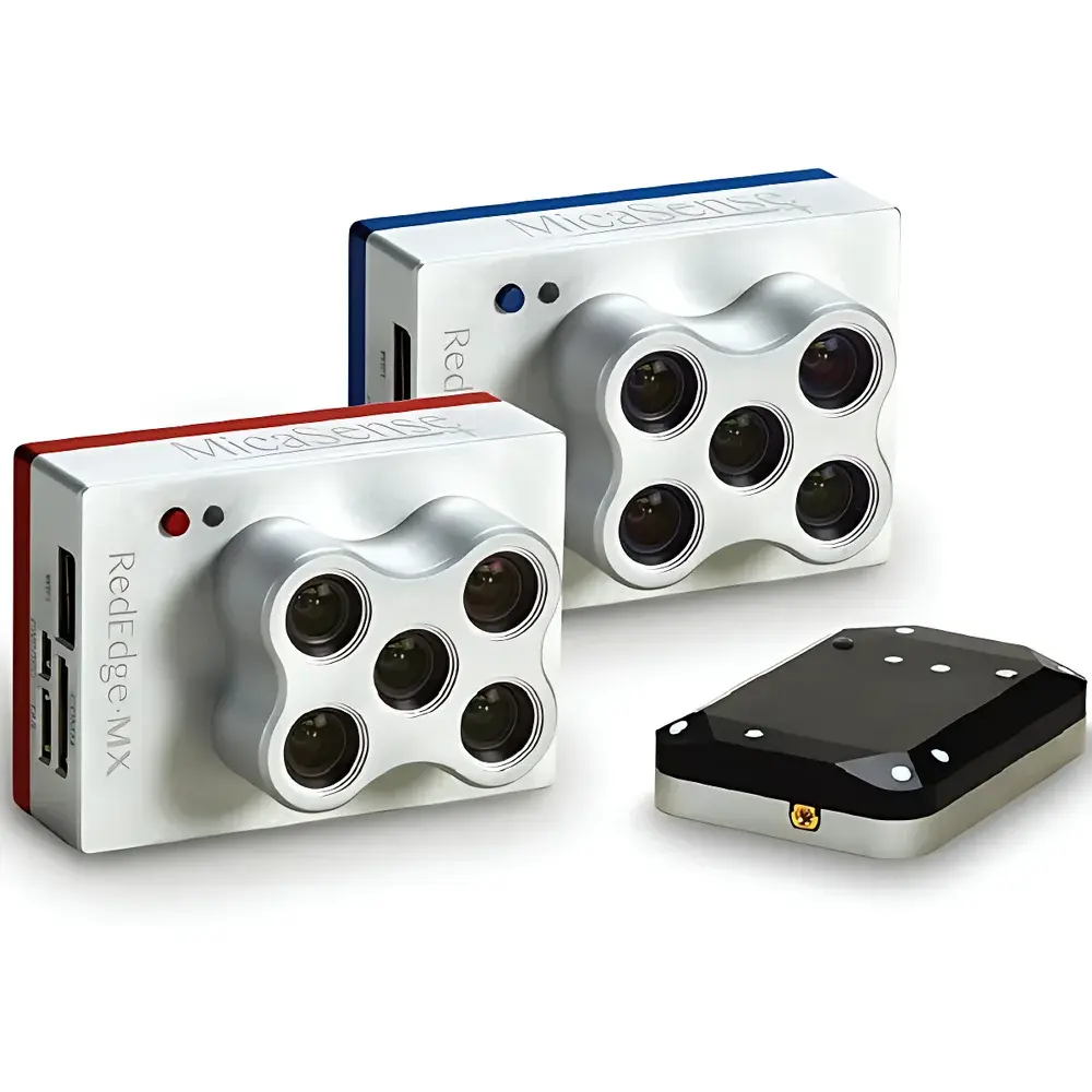
MicaSense RedEdge-MX + RedEdge-MX Blue 10-Channel Synchronized Multispectral Imaging System
| Origin | USA |
|---|---|
| Manufacturer Type | Authorized Distributor |
| Origin Category | Imported |
| Model | RedEdge-MX + RedEdge-MX Blue 10-Channel System |
| Pricing | Upon Request |
| Weight | 508.8 g (including both sensors, dual-sensor mounting plate, DLS2, and cables) |
| Dimensions | 8.7 cm × 12.3 cm × 7.6 cm |
| Power Supply | 4.2–18.8 V DC |
| Spectral Bands | Coastal Blue (444 nm, 28 nm FWHM), Green (531 nm, 14 nm), Red (650 nm, 16 nm), Red Edge (705 nm, 10 nm), Red Edge (740 nm, 18 nm), Blue (475 nm, 32 nm), Green (560 nm, 27 nm), Red (668 nm, 14 nm), Red Edge (717 nm, 12 nm), NIR (842 nm, 57 nm) |
| RGB Output | 3.6 MP (global shutter, pixel-aligned across all bands) |
| Spatial Resolution | 1280 × 960 per band (1.2 MP per channel) |
| Ground Sampling Distance (GSD) | 8 cm/pixel at 120 m AGL |
| Capture Rate | 1 image/sec (full 10-band capture) |
| Interfaces | UART, 10/100/1000 Ethernet, removable Wi-Fi module, external trigger input, integrated GPS, SDHC card slot |
| Field of View | 47.2° diagonal |
| Trigger Modes | Timed, overlap-based, external TTL, manual |
| Operating Temperature | 0–40°C (no airflow) |
Overview
The MicaSense RedEdge-MX + RedEdge-MX Blue 10-Channel Synchronized Multispectral Imaging System is an engineered solution for high-fidelity ecological remote sensing and precision agriculture research. Built upon the industry-proven RedEdge-MX platform and extended with the newly introduced RedEdge-MX Blue sensor, this dual-sensor configuration delivers synchronized acquisition across ten discrete, radiometrically calibrated spectral bands—enabling advanced biophysical parameter retrieval beyond conventional five-band systems. The system operates on the principle of push-broom–free, frame-based multispectral imaging using global-shutter CMOS sensors with precisely aligned optical paths and factory-calibrated spectral response functions. Each band is optimized for atmospheric transmission windows and vegetation spectral signatures, supporting quantitative reflectance modeling under variable illumination conditions via integrated Downwelling Light Sensor (DLS2) and GNSS synchronization. Designed for integration into fixed-wing and multirotor unmanned aerial systems (UAS), it supports rigorous scientific workflows requiring traceable radiometry, spatial registration integrity, and temporal coherence across spectral channels.
Key Features
- Synchronized 10-channel capture in a single flight pass—eliminating temporal misregistration between spectral layers and enabling robust time-series analysis.
- Modular co-mounting architecture: Both RedEdge-MX and RedEdge-MX Blue share a common mounting plate, DLS2 unit, and GPS module—reducing total payload mass and power draw while ensuring identical geometric and radiometric reference frames.
- Coastal blue band (444 nm) enables improved aerosol correction, turbidity mapping, and shallow-water benthic feature discrimination—critical for coastal zone monitoring and inland water quality assessment per EPA Method 120.1 and ISO 10264-2.
- Dual red-edge bands (705 nm & 740 nm from MX; 717 nm from MX Blue) support high-resolution estimation of chlorophyll content, nitrogen status, and red-edge inflection point (REIP) slope—parameters directly linked to photosynthetic efficiency and stress physiology.
- Full spectral interchangeability: Band assignments are software-definable, permitting custom index derivation (e.g., modified NDVI, CCI, MCARI2) and empirical model development without hardware reconfiguration.
- Ready-to-fly compatibility with EcoDrone UAS-4/UAS-8 platforms and mechanical integration kits for DJI Matrice and Phantom series—requiring no gimbal, thanks to rigid passive stabilization and sub-pixel boresight alignment.
Sample Compatibility & Compliance
The system is validated for use over vegetated land surfaces, aquatic ecosystems (lakes, estuaries, coral reefs), and heterogeneous terrain typical of agroecological landscapes. Radiometric calibration adheres to NIST-traceable protocols using certified reflectance panels (included), and raw DN values are converted to at-sensor reflectance using onboard DLS2 irradiance measurements and empirical dark-current compensation. Data products comply with FAO’s WaPOR framework metadata standards and support interoperability with ENVI, QGIS, and Google Earth Engine pipelines. The hardware design conforms to IEC 60950-1 for electrical safety and meets MIL-STD-810G environmental ruggedness requirements for airborne deployment. Firmware supports audit-ready logging per GLP-compliant field data collection workflows.
Software & Data Management
Data acquisition and preprocessing are managed through MicaSense’s proprietary AgVault and Atlas cloud platforms, which provide automated radiometric correction, orthomosaic generation, and spectral index computation. Raw TIFF sequences include embedded EXIF tags containing GPS position, IMU attitude, DLS2 irradiance, and temperature-compensated sensor gain settings. Export formats include GeoTIFF (with RPC metadata), CSV (band statistics per pixel), and HDF5 (for time-series stacking). All processing logs are timestamped and user-attributed, satisfying documentation requirements under FDA 21 CFR Part 11 for regulated agricultural trials and environmental impact assessments.
Applications
- Crop phenotyping and high-throughput trait quantification in breeding programs (e.g., canopy structure, senescence timing, drought resilience).
- Seasonal crop health monitoring using time-series NDVI, EVI, and red-edge ratio indices—aligned with USDA CropScape classification hierarchies.
- Abiotic and biotic stress detection—including nutrient deficiency (N, Fe), water deficit, and early-stage fungal infection—via spectral derivative analysis.
- Wetland and riparian ecosystem mapping, including invasive species delineation (e.g., Phragmites australis) and hydroperiod validation.
- Shallow marine and lacustrine monitoring: suspended sediment load, chlorophyll-a concentration, and seagrass meadow extent estimation using coastal blue/NIR ratios.
- Chlorophyll fluorescence proxy modeling via red-edge inflection point shift analysis—correlated with PAM fluorometry benchmarks in peer-reviewed plant physiology studies.
FAQ
Is radiometric calibration performed in-field or only at the factory?
Factory calibration is performed using NIST-traceable integrating sphere sources; however, in-field calibration is supported via included Spectralon reflectance panels and DLS2-coupled normalization—enabling daily radiometric consistency verification.
Can the system be operated without GPS or DLS2?
Yes—though georeferencing and absolute reflectance accuracy degrade significantly; standalone operation is limited to relative spectral analysis within a single mosaic.
Does the system support RTK or PPK positioning inputs?
Yes—external GNSS receivers delivering RTCM3 or RINEX corrections can be integrated via UART or Ethernet for centimeter-level geolocation fidelity.
What spectral indices are pre-configured in Atlas software?
Over 30 indices are available—including NDVI, GNDVI, NDRE, CIred-edge, SR, EVI, SAVI, and custom user-defined formulas with real-time preview.
Is firmware update capability available over-the-air?
Firmware updates require USB connection to a host computer running MicaSense Device Manager; OTA updates are not supported for security and traceability reasons.
Related Products


