EcoTech PhenoPlot® Mobile Field Plant Phenotyping Platform
| Brand | EcoTech |
|---|---|
| Origin | Beijing, China |
| Model | PhenoPlot® Mobile |
| Spectral Range (Standard) | 400–1000 nm (448 bands) |
| Optional Hyperspectral Modules | 900–1700 nm (224 bands) |
| Thermal Imaging Resolution | 640 × 512 px (super-resolved to 1266 × 1010) |
| Fluorescence Imaging | Modulated chlorophyll fluorescence CCD (720 × 560 px, 50 fps) |
| Scan Area (at 150 cm working distance) | 150 × 100 cm |
| Positioning Accuracy | ±1 cm |
| Battery Runtime | >8 hours |
| Software | SpectrAPP©, Thermo-RGB©, FluoroScan© |
Overview
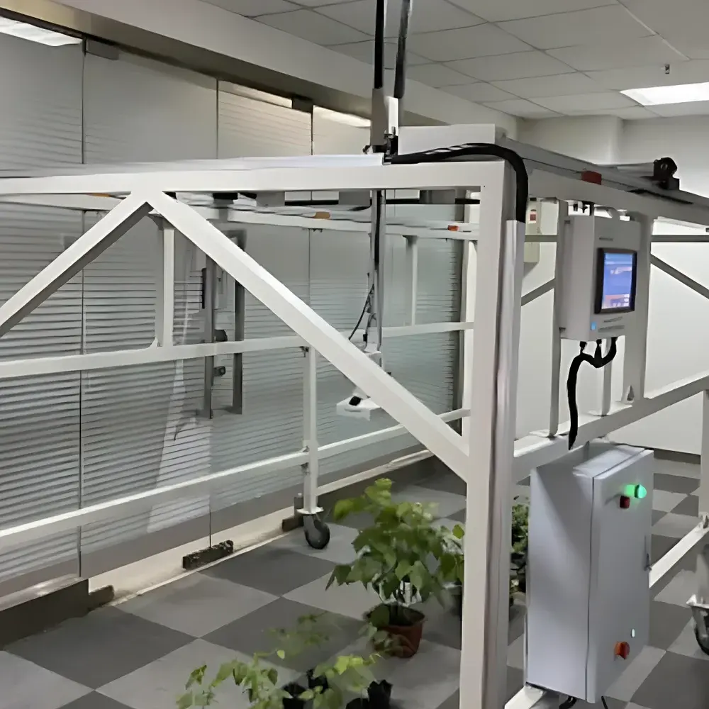
The EcoTech PhenoPlot® Mobile Field Plant Phenotyping Platform is an integrated, sensor-to-plant (STP) imaging system engineered for high-resolution, in-situ phenotypic characterization of crops and model plants under field, greenhouse, or controlled-environment conditions. It operates on a motorized four-wheel chassis with programmable X-Z axis positioning, enabling precise, non-destructive optical scanning across plots, iPOT mesocosms, miniPlots, or soil-plant systems. The platform integrates multiple co-registered modalities—including visible-near-infrared (VNIR) hyperspectral imaging (400–1000 nm), optional shortwave infrared (SWIR) hyperspectral imaging (900–1700 nm), Thermo-RGB© thermal–visible fusion imaging, and modulated chlorophyll fluorescence imaging—within a single synchronized acquisition framework. Its core measurement principles include reflectance spectroscopy (for pigment, water, nitrogen, and structural indices), thermal emission radiometry (for stomatal conductance proxies and stress-induced canopy temperature differentials), and pulse-amplitude-modulated (PAM) fluorometry (for photosynthetic efficiency and photochemical quenching dynamics). Designed for reproducible longitudinal monitoring, the system supports GLP-aligned data capture with embedded GPS, real-time environmental logging (ambient temperature, humidity, PAR, UTC timestamp), and audit-trail-capable software workflows compliant with ISO 20673:2021 (Plant Phenotyping — Terminology and General Principles) and FAO/CGIAR best practices for field-based trait quantification.
Key Features
- Motorized dual-axis (X-Z) positioning system with ±1 cm spatial repeatability; enables automated raster scanning over variable plot dimensions (standard scan area: 150 × 100 cm at 150 cm working distance)
- Embedded 10-inch touchscreen HMI running real-time Linux OS; unified control interface for platform motion, illumination sequencing, sensor triggering, and protocol execution
- Modular sensor architecture: Interchangeable VNIR hyperspectral camera (448 spectral bands, FWHM 5.5 nm, SNR 400:1), SWIR module (224 bands, SNR peak 1000:1), uncooled microbolometer thermal imager (NETD ≤0.05 °C), and PAM fluorometer (720 × 560 px, 50 fps, 620/735 nm LED excitation)
- Onboard environmental sensing suite: Integrated GPS (UTC-synchronized time stamping), ambient temperature/humidity, PAR sensor, and expandable I/O for soil moisture, CO2, net radiation, and canopy temperature probes
- Battery-powered operation (>8 h continuous runtime); ruggedized aluminum frame with lockable casters for rapid deployment on uneven terrain or greenhouse floors
- Protocol-driven automation: Up to 10 user-defined acquisition sequences (e.g., multi-modal time-series scans, light-response curves, dark-adapted Fv/Fm protocols) executable without external PC
Sample Compatibility & Compliance
The PhenoPlot® platform accommodates diverse experimental configurations: field-scale plots (up to 2 m × 1.8 m footprint), greenhouse-grown rows, Soiltron®-based iPOT lysimeters, and miniPlot soil-plant units. Its STP geometry ensures consistent illumination geometry and minimal shadowing across heterogeneous canopies—even under moderate wind-induced plant motion—via high-frame-rate imaging (≥330 fps full-frame VNIR, 670 fps SWIR). All optical modules comply with IEC 62471 (Photobiological Safety) and EN 61326-1 (EMC for laboratory equipment). Data provenance meets ISO/IEC 17025:2017 requirements for measurement traceability, with embedded metadata (GPS coordinates, UTC timestamps, sensor calibration IDs, environmental context) stored in HDF5 format. Spectral indices (e.g., NDVI, PRI, PSRI, NPQI, CRI1) are computed using NIST-traceable reflectance standards and validated against ASTM E2799-22 (Standard Guide for Hyperspectral Imaging Data Acquisition and Processing).
Software & Data Management
SpectrAPP© serves as the central analytical engine, supporting batch processing of hyperspectral cubes, ROI-based spectral unmixing, automatic peak detection (e.g., red-edge inflection points), and export of >90 biophysically interpretable vegetation indices. Thermo-RGB© enables pixel-level thermal–visible registration, quantitative ROI temperature mapping (min/max/mean), and morphometric analysis (convex hull area, circularity, aspect ratio) of canopy sub-regions. FluoroScan© implements standardized chlorophyll fluorescence protocols (Fv/Fm, Kautsky kinetics, light-response curves) with automated parameter extraction (Y(II), NPQ, qP, ETR, Rfd) and spatiotemporal visualization. All software modules enforce FDA 21 CFR Part 11 compliance via electronic signatures, audit trails, role-based access control, and immutable raw-data archiving. Export formats include GeoTIFF (georeferenced reflectance maps), CSV (time-series trait tables), and MATLAB-compatible .mat files for downstream modeling.
Applications
- Field-based QTL mapping and GWAS validation through high-throughput temporal monitoring of drought, heat, or nutrient-stress responses
- Non-invasive assessment of photosynthetic performance across breeding populations using spatially resolved Fv/Fm and Y(II) maps
- Early detection of biotic stress (e.g., fungal infection, aphid infestation) via anomalous PRI/PSRI trajectories and thermal heterogeneity patterns
- Quantification of canopy water status using WBIR and Tc-Ta differential metrics under deficit irrigation trials
- Phenotyping root-zone interactions in Soiltron® systems via coupled soil reflectance + root thermal signature analysis
- Validation of satellite- and UAV-derived vegetation indices through ground-truth spectral libraries acquired at plot scale
FAQ
What is the minimum required working distance for full-plot VNIR hyperspectral imaging?
The standard configuration achieves optimal signal-to-noise ratio and spatial uniformity at a working distance of 150 cm, covering a 150 × 100 cm area. At reduced distances (e.g., 43 cm), the field of view narrows to 150 × 30 cm for high-magnification leaf-level analysis.
Can the system operate autonomously overnight in unattended field deployments?
Yes—the onboard battery, GPS-synchronized clock, and protocol scheduler support scheduled multi-hour acquisitions. Environmental sensors log contextual metadata continuously, and data are written to internal SSD with error-correcting file system integrity checks.
Is spectral calibration traceable to national standards?
All hyperspectral modules are factory-calibrated using NIST-traceable tungsten-halogen and diffuse reflectance standards (Labsphere Spectralon®). Users receive calibration certificates with wavelength accuracy ±0.3 nm and radiometric uncertainty <3% (k=2).
How does the system handle plant motion during scanning?
High frame rate (≥330 fps), global shutter operation, and motion-compensated scanning algorithms minimize motion blur. The platform’s mechanical rigidity and active stabilization reduce vibration artifacts, ensuring sub-pixel registration fidelity even in wind-exposed field settings.
Are software updates and calibration maintenance provided under warranty?
EcoTech provides 24-month hardware warranty and complimentary annual software updates including new index algorithms, regulatory-compliance patches (e.g., Part 11 enhancements), and spectral recalibration services performed remotely or on-site by certified field engineers.


