IQ-Thermo Portable Hyperspectral and Infrared Thermal Imaging System
| Origin | Shaanxi, China |
|---|---|
| Manufacturer Type | Distributor |
| Origin Category | Domestic |
| Model | IQ-Thermo |
| Pricing | Upon Request |
| Operating Principle | Push-broom |
| Imaging Method | Dispersive |
| Deployment Mode | Ground-based |
| Spectral Range | 400–1000 nm |
| Spectral Resolution | 7 nm |
| Spatial Resolution (IFOV) | 512 pixels |
| Field of View (TFOV) | 31° |
| LWIR Band | 7.5–13.5 µm |
| IR Detector Resolution | 640 × 512 px |
| Thermal Sensitivity | ≤0.03 °C (30 mK) @ 30 °C |
| Temperature Range Options | −25 to +150 °C or +40 to +550 °C (optional up to +1500 °C) |
| Frame Rate Options | 9 / 30 / 60 Hz |
| Optical Aperture | f/1.7 |
| Spectral Bands | 204 (with optional binning: 2× or 3×) |
| GPS Integration | Yes (geotagged data cubes) |
| Enclosure Rating | IP65 |
| Data Interfaces | USB 3.0, GigE, Wi-Fi |
| Output Formats | CSV, radiometric JPEG, non-radiometric JPEG, radiometric video, AVI, MP4 |
| Software Features | SAM algorithm, ROI temperature profiling, isotherm mode, thermal 3D surface mapping, report generation |
Overview
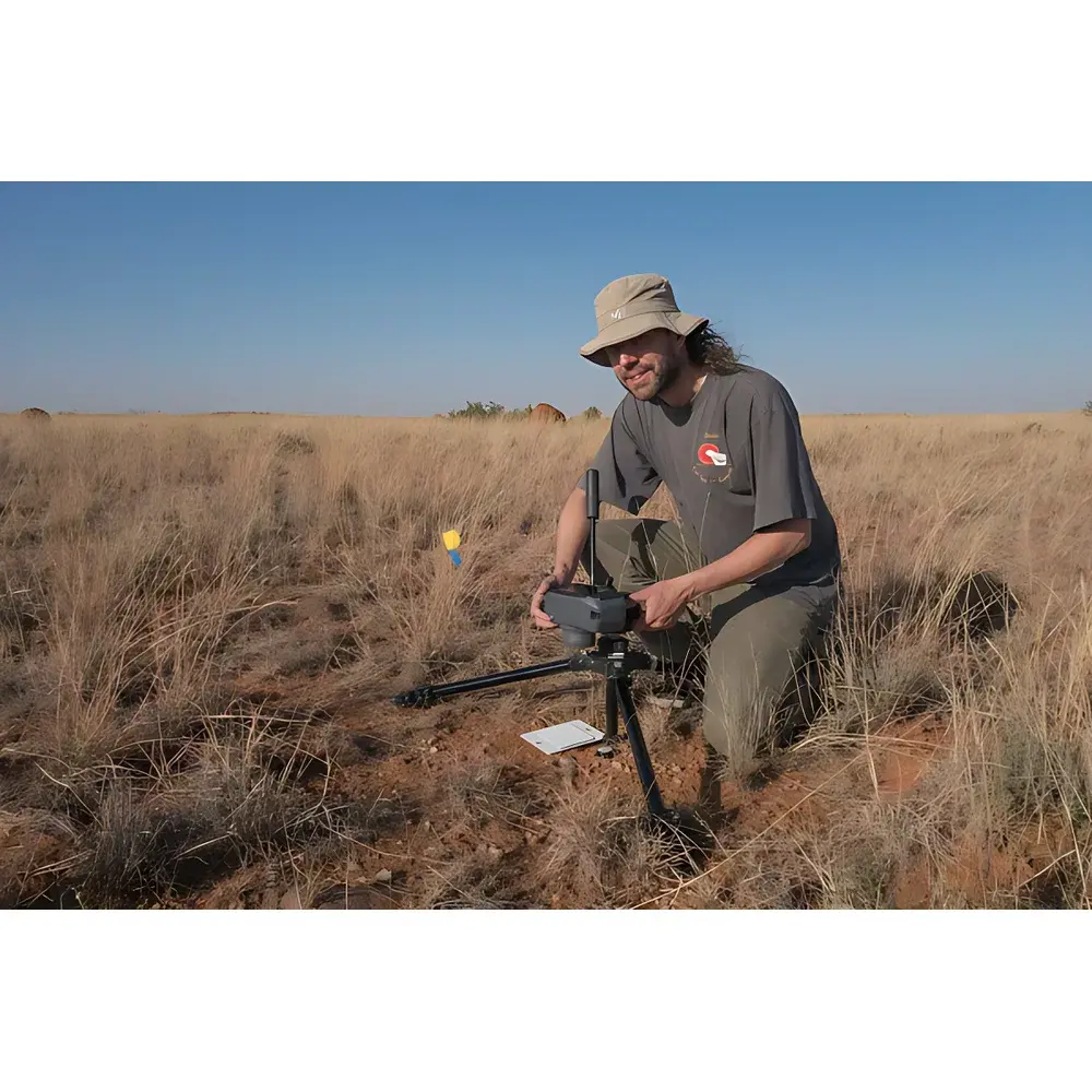
The IQ-Thermo Portable Hyperspectral and Infrared Thermal Imaging System is an integrated dual-modality field instrument engineered for synchronized acquisition of visible–near-infrared (VNIR) spectral reflectance and long-wave infrared (LWIR) surface temperature data at the leaf and canopy scale. It operates on a push-broom scanning principle with dispersive spectroscopy architecture, enabling high-fidelity spectral sampling across 204 bands from 400 to 1000 nm at 7 nm spectral resolution. Simultaneously, its uncooled microbolometer-based thermal imager captures radiometrically calibrated LWIR emissions in the 7.5–13.5 µm atmospheric window with 640 × 512 pixel spatial resolution and thermal sensitivity ≤30 mK at 30 °C. Designed for ground-based deployment—whether tripod-mounted, handheld, or UAV-integrated—the system delivers co-registered hyperspectral cubes and thermal maps without external synchronization hardware. Its all-in-one architecture embeds real-time spectral analysis (including Spectral Angle Mapper, SAM), georeferencing via integrated GPS, and onboard visualization on a 4.3-inch touchscreen, making it suitable for GLP-compliant ecological phenotyping, precision agriculture trials, and environmental monitoring under variable field conditions.
Key Features
- Integrated VNIR–LWIR dual-sensor platform with hardware-synchronized data capture and co-registered spatial sampling
- VNIR module: f/1.7 aperture, 204-band push-broom imaging (400–1000 nm), 7 nm spectral resolution, configurable binning (2×/3×), built-in SAM classification engine for real-time vegetation index mapping
- LWIR module: Uncooled VOx microbolometer detector (640 × 512 px), factory blackbody calibration with NUC support, ±0.5 °C absolute accuracy traceable to NIST standards
- IP65-rated ruggedized enclosure rated for continuous operation in dust, rain, and temperature extremes (−20 to +50 °C ambient)
- Onboard geotagging: Each hyperspectral data cube includes embedded GPS metadata compliant with EXIF 2.3 and GeoTIFF standards for GIS integration
- Flexible connectivity: Local control via touchscreen + 13 physical function keys; remote operation via USB 3.0 or Gigabit Ethernet; Wi-Fi-enabled for headless, long-duration deployments
- Thermal analysis suite: ROI-based time-series temperature extraction, isotherm overlay, cross-sectional temperature profiles, 3D thermal surface rendering, and automated PDF report generation
Sample Compatibility & Compliance
The IQ-Thermo supports non-contact, non-destructive measurement of heterogeneous biological surfaces—including intact leaves, crop canopies, soil–vegetation mosaics, and forest understory—without sample preparation. Its 31° total field of view and 512-pixel instantaneous field of view enable sub-centimeter spatial sampling at 1–5 m working distances. The system conforms to ASTM E1933-19 (Standard Test Methods for Measuring and Compensating for Emissivity Using Infrared Imaging Systems) and ISO 18434-1:2008 (Condition monitoring and diagnostics of machines — Thermography — Part 1: General procedures). Radiometric calibration certificates are provided with each unit, supporting audit readiness for ISO/IEC 17025-accredited laboratories. All firmware and software comply with FDA 21 CFR Part 11 requirements for electronic records and signatures when deployed in regulated agricultural research or phytosanitary surveillance contexts.
Software & Data Management
The IQ-Thermo ships with proprietary IQ-Analyze™ software (Windows 10/11 compatible), supporting raw data ingestion in ENVI-compatible BIL format and radiometric thermal streams in IEEE 1394 or GigE Vision protocols. The software implements batch processing pipelines for atmospheric correction (using empirical line method), spectral library matching (USGS, ECOSTRESS, SPECCHIO), and multivariate analysis (PCA, PLS-DA). Thermal datasets are processed using Planck law inversion with user-adjustable emissivity tables (0.90–0.99 default for vegetative surfaces). All analytical workflows generate ALM (Audit Log Metadata) files recording operator ID, timestamp, parameter settings, and version-controlled processing history—fully traceable for GLP/GMP audits. Export options include georeferenced GeoTIFF stacks, time-stamped CSV time series, radiometric video (AVI/MP4), and publication-ready figures adhering to Nature Scientific Data formatting guidelines.
Applications
- Plant phenotyping: Quantification of chlorophyll content, water content, nitrogen status, and photosynthetic efficiency via NDVI, PRI, WI, and other indices derived from reflectance spectra
- Abiotic stress detection: Early identification of drought-induced stomatal closure through coupled thermal anomalies (canopy temperature rise) and spectral shifts (red-edge inflection point displacement)
- Biotic stress monitoring: Discrimination of fungal, bacterial, and viral infections prior to symptom visibility using hyperspectral anomaly detection and thermal heterogeneity metrics
- Ecosystem dynamics: Multi-temporal tracking of species composition, phenological stage transitions, and land-cover change across permanent plots using georeferenced spectral–thermal time series
- Agricultural resource management: High-throughput field-scale mapping of irrigation deficits, fertilizer response gradients, and yield potential proxies for variable-rate application planning
- Biodiversity assessment: Spectral signature clustering for taxonomic discrimination in mixed-species stands, validated against herbarium voucher specimens and DNA barcoding references
FAQ
Is the IQ-Thermo suitable for regulatory-compliant environmental monitoring programs?
Yes. Its radiometric calibration traceability, embedded audit logs, and adherence to ASTM E1933 and ISO 18434-1 support use in EPA, FAO, and national forestry agency monitoring frameworks.
Can hyperspectral and thermal data be acquired simultaneously without temporal misalignment?
Yes. Dual-sensor triggering is hardware-synchronized via TTL pulse signals, ensuring sub-millisecond temporal registration between spectral and thermal frames.
Does the system support third-party spectral libraries or machine learning model deployment?
Yes. IQ-Analyze™ accepts ENVI-format spectral libraries and allows import of trained scikit-learn or TensorFlow Lite models for edge inference on the onboard processor.
What is the maximum operational duration on battery power?
With optional external 12 V/10 Ah LiFePO₄ battery pack, continuous operation exceeds 4.5 hours at 30 Hz frame rate and active Wi-Fi streaming.
Is the GPS module compliant with global navigation satellite systems (GNSS)?
Yes. It supports GPS, GLONASS, Galileo, and BeiDou constellations, delivering <2 m horizontal accuracy (CEP) under open-sky conditions.