Video Raindrop Spectrometer
| (Origin | Imported |
|---|---|
| Manufacturer Type | Authorized Distributor |
| Model | Video Raindrop Spectrometer |
| Price | Available Upon Request) |
| [Horizontal Resolution | 0.19 mm |
| Vertical Resolution | 0.19 mm (for vertical velocity < 10 m/s) |
| Vertical Velocity Accuracy | ±4% (for vertical velocity < 10 m/s) |
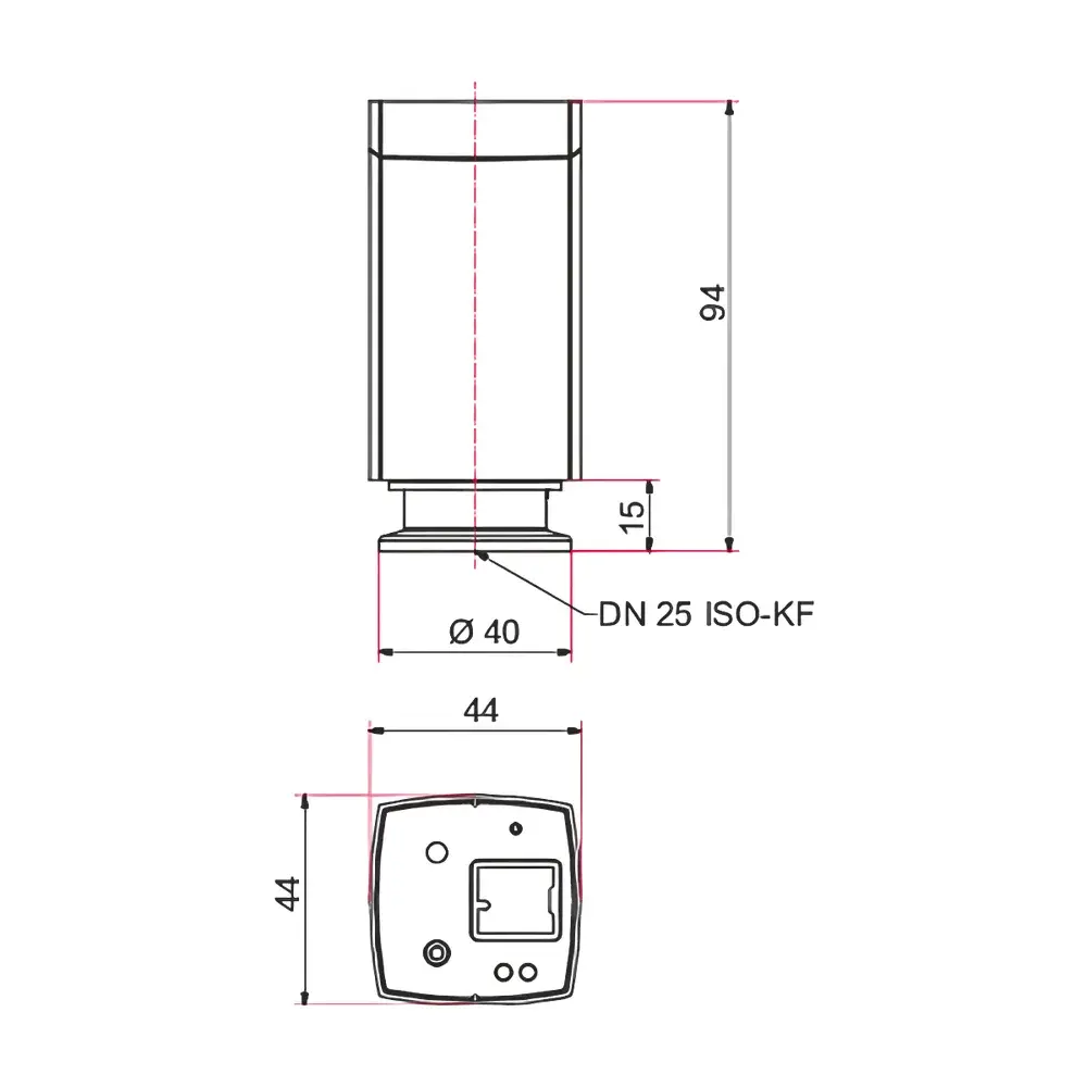
| Scanning Area | 100 × 100 mm² |
| Integration Time | 15 s to 12 h (configurable for display and storage) |
| Data Storage Density | 2–4 MB per mm of accumulated rainfall (typical) |
| Power Supply | 100–240 V AC, 50/60 Hz |
| Power Consumption | 500 W |
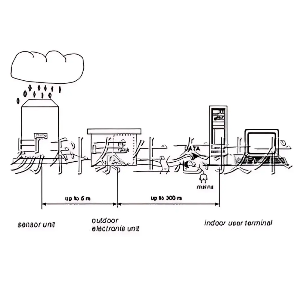
| Sensor Unit Dimensions | 1100 × 1100 × 350 mm (L×W×H), ~85 kg |
| Outdoor Electronics Unit Dimensions | 750 × 600 × 300 mm (L×W×H), ~45 kg |
| Minimum Detectable Drop Diameter | 0.19 mm] |
Overview
The Video Raindrop Spectrometer is a high-resolution optical precipitation profiling instrument engineered for quantitative microphysical characterization of falling hydrometeors. Based on dual high-speed camera stereo imaging and synchronized line-scan acquisition, it captures real-time two-dimensional projections of raindrops within a defined measurement volume. Unlike traditional disdrometers relying on impact acoustics or laser attenuation, this system reconstructs drop size, shape, orientation, and terminal velocity through pixel-accurate image analysis—enabling derivation of equivalent spherical diameter (Deq), axial ratio (flatness), horizontal drift velocity, and vertical fall speed with traceable geometric calibration. Developed in collaboration with the European Space Agency (ESA) and the European Space Research and Technology Centre (ESTEC), the instrument meets stringent requirements for ground-truth validation of weather radar algorithms, cloud microphysics modeling, and climate-scale precipitation climatology.
Key Features
- Dual-camera stereoscopic imaging architecture with synchronized line-scan mode for motion-compensated capture of fast-falling drops (up to 10 m/s)
- Sub-millimeter spatial resolution: 0.19 mm horizontal and vertical resolution, enabling reliable detection of drizzle droplets down to 0.19 mm Deq
- Full-field measurement volume of 100 × 100 mm²—optimized for statistical representativeness while minimizing wind-induced sampling bias
- Integrated backlight illumination with uniform intensity profile, ensuring consistent contrast across the entire scan area
- Real-time onboard processing in the outdoor electronics unit: image binarization, centroid tracking, contour extraction, and velocity vector computation
- Ruggedized outdoor-rated enclosure (IP65) for continuous unattended operation in diverse climatic conditions—from sub-zero alpine sites to tropical coastal installations
- Modular three-part architecture: sensor unit (optical head), outdoor electronics unit (data acquisition & preprocessing), and indoor user terminal (analysis workstation)
Sample Compatibility & Compliance
The Video Raindrop Spectrometer is validated for natural precipitation events including drizzle, rain, melting snow, and graupel. It does not require physical contact or disruption of hydrometeor trajectories—preserving natural aerodynamic behavior and eliminating splashing artifacts common in impact-based systems. Calibration is traceable to NIST-traceable dimensional standards and verified using precision-machined spherical targets and controlled free-fall test rigs. The system complies with WMO Guide to Instruments and Methods of Observation (CIMO Guide, Chapter 12) for precipitation measurement. Data output formats adhere to CF-NetCDF conventions for interoperability with meteorological data archives (e.g., EUMETNET, NOAA NCEI). Firmware and software support audit trails, time-stamped metadata embedding, and configurable data retention policies aligned with GLP and ISO/IEC 17025 documentation requirements.
Software & Data Management
The proprietary analysis suite provides both real-time monitoring and post-processing capabilities. Users can visualize temporal evolution of rain rate, drop size distribution (DSD), velocity–diameter relationships, and shape–size correlations via interactive dashboards. All raw image sequences and processed parameter files (including drop-by-drop CSV exports) are stored locally with configurable integration intervals (15 s to 12 h). The software supports batch reprocessing with updated calibration matrices or algorithm versions, ensuring long-term data consistency across multi-year observational campaigns. Export modules generate standardized reports compliant with WMO BUFR templates and integrate with Python-based atmospheric science workflows (via HDF5 and NetCDF4 APIs). Optional FDA 21 CFR Part 11-compliant configuration includes electronic signatures, role-based access control, and immutable audit logs for regulated environments.
Applications
- Ground-truth calibration and validation of operational weather radar systems (C-band, X-band, dual-polarization)
- Microphysical parameterization development for numerical weather prediction (NWP) and climate models
- Urban hydrology studies: high-resolution rainfall input for stormwater runoff modeling and sewer overflow forecasting
- Airport meteorological observatories: real-time detection of low-level wind shear precursors, freezing rain onset, and visibility-reducing precipitation types
- Atmospheric electricity research: correlation of drop size/velocity distributions with charge separation mechanisms in thunderstorms
- Transportation safety systems: adaptive road surface condition monitoring and fog/rain-induced visibility assessment
- Long-term climate observatories: decadal-scale analysis of precipitation intensity-frequency-duration trends under changing climate regimes
FAQ
What is the minimum detectable raindrop diameter?
The system reliably detects spherical-equivalent diameters ≥ 0.19 mm under standard atmospheric conditions (vertical velocity < 10 m/s).
Can the instrument operate continuously during heavy rainfall or strong winds?
Yes—the sensor and electronics units are rated IP65 and designed for year-round outdoor deployment; optional wind shields and heated optics packages are available for extreme environments.
Is the system compatible with existing meteorological data acquisition networks?
It supports MODBUS TCP, ASCII serial output, and FTP-based automated file transfer; integration with Campbell Scientific CR-series loggers and IRIS data ingestion pipelines is documented.
Does the software provide uncertainty quantification for derived parameters?
Yes—each computed parameter (e.g., Deq, fall speed, flatness) includes propagated uncertainty estimates based on pixel resolution, timing jitter, and calibration variance.
How is geometric calibration performed and maintained?
A two-stage process: factory calibration using precision grid targets and in-situ verification using suspended reference spheres; field recalibration tools are included in the software suite.