Xylem SonTek RS5 RiverSurveyor Mobile Acoustic Doppler Current Profiler (ADCP)
| Brand | Xylem |
|---|---|
| Origin | USA |
| Manufacturer Type | Authorized Distributor |
| Product Origin | Imported |
| Model | RS5 RiverSurveyor Mobile ADCP |
| Pricing | Upon Request |
Overview
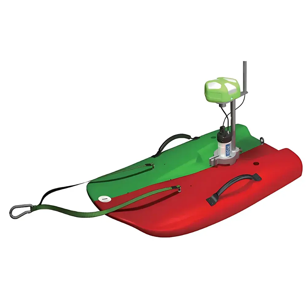
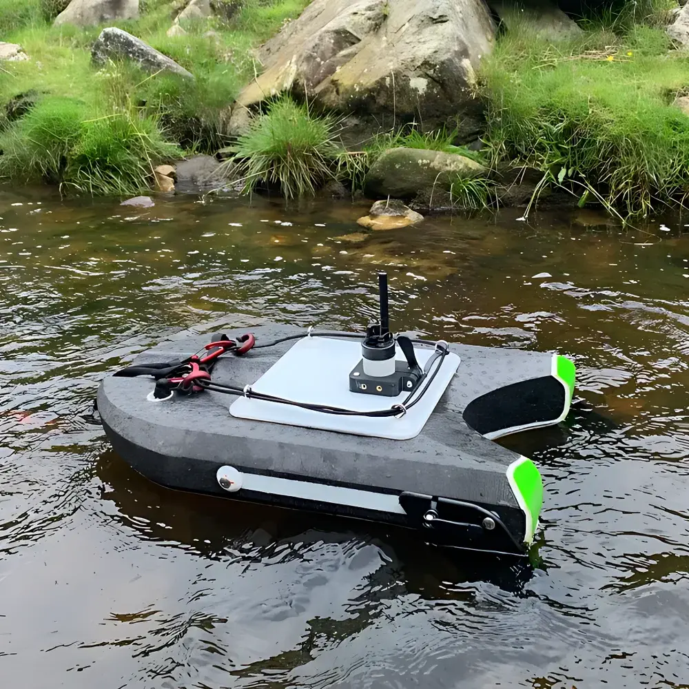
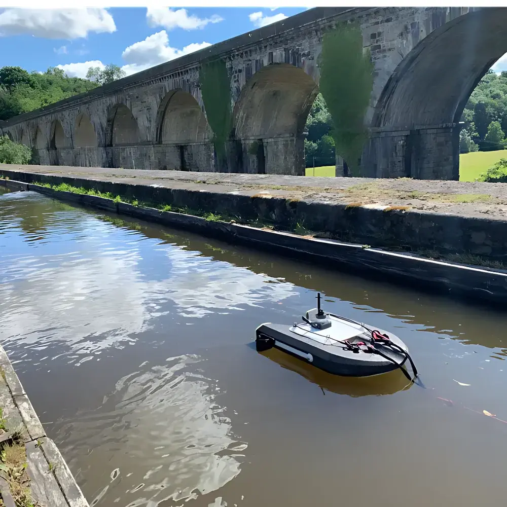
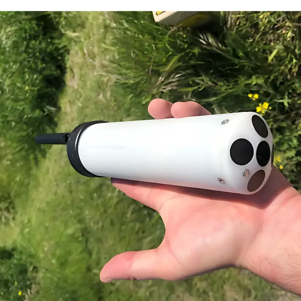
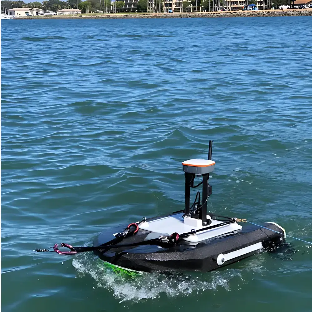
The Xylem SonTek RS5 RiverSurveyor Mobile Acoustic Doppler Current Profiler (ADCP) is a compact, high-precision, vessel-mounted instrument engineered for real-time, high-resolution river discharge measurement and velocity profiling in dynamic open-channel environments. Operating on the principle of broadband pulse-coherent acoustic Doppler velocimetry, the RS5 transmits and receives ultrasonic pulses across multiple beams—primarily utilizing a vertical beam configuration—to resolve water column velocity structure with exceptional spatial resolution and temporal stability. Its vertically oriented transducer array enables direct measurement of depth beneath the vessel, supporting accurate cross-sectional area determination even under variable bed conditions. When bottom tracking is unavailable—due to sediment-laden water, shallow depths, or highly mobile substrates—the system seamlessly transitions to water-tracking mode, extending profiling capability to the full water column while maintaining velocity accuracy within ±0.5% of measured velocity + 0.1 cm/s (typical). Designed for field-deployable hydrological surveying, the RS5 integrates inertial motion compensation, georeferenced data acquisition, and adaptive signal processing to deliver metrologically traceable flow data compliant with ISO 748:2022 (Measurement of liquid flow in open channels — Velocity-area method) and ASTM D5389-21 (Standard Practice for Measuring Open Channel Flow Using Acoustic Doppler Current Profilers).
Key Features
- Vertical-beam architecture for direct depth measurement and optimized cross-sectional area calculation
- SmartPulse+® adaptive signal processing engine combining pulse-coherent and broadband acoustic profiling to enable reliable bottom tracking in water depths as shallow as 0.2 m
- High-resolution velocity bin size down to 2.5 cm, enabling fine-scale turbulence and shear analysis
- Integrated 360° solid-state digital compass and dual-axis tilt sensor for real-time heading correction, pitch/roll compensation, and motion-corrected depth & velocity vector alignment
- Acoustic bottom tracking for vessel-relative velocity estimation and secondary depth validation
- Optional RTK GPS support for centimeter-level positioning accuracy (<2 cm horizontal, <3 cm vertical), critical for mobile-bed rivers or low-velocity zones where acoustic bottom lock is unstable
- Optional integrated DGNSS smart antenna for sub-meter positioning redundancy, compatible with NTRIP/CORS networks and SonTek RTK base stations
- Lightweight, modular design (≤3.2 kg transducer head) optimized for small boats, kayaks, and autonomous surface vehicles (ASVs)
Sample Compatibility & Compliance
The RS5 is validated for use in natural rivers, irrigation canals, stormwater conveyances, and tidal estuaries with flow velocities ranging from 0.01 to 5.0 m/s and depths from 0.2 m to 40 m (dependent on frequency and water clarity). It accommodates suspended sediment concentrations up to 10 g/L and operates reliably in turbid, aerated, or thermally stratified water columns. The system complies with IEC 60529 IP68 ingress protection rating and meets electromagnetic compatibility requirements per EN 61326-1:2013. Data output formats (NMEA 0183, PD0, CSV) support integration into hydraulic modeling platforms (e.g., HEC-RAS, MIKE SHE) and regulatory reporting workflows aligned with USGS, EPA, and EU WFD monitoring protocols.
Software & Data Management
Data acquisition, real-time visualization, and post-processing are managed via SonTek’s RiverSurveyor Live software—a Windows-based application supporting automated transect planning, live velocity vector overlays, and QA/QC flagging per USGS Water Resources Mission Area standards. All raw and processed datasets include embedded metadata (GPS time stamps, motion sensor logs, signal-to-noise ratios, beam geometry), enabling full auditability. Software supports FDA 21 CFR Part 11–compliant user access controls, electronic signatures, and immutable audit trails when deployed in GLP/GMP-regulated environmental monitoring programs.
Applications
- Regulatory-compliant streamflow gauging and stage-discharge relationship development
- Flood forecasting and emergency response hydrography during extreme weather events
- Sediment transport quantification and mobile-bed morphodynamics assessment
- Wastewater outfall dispersion monitoring and effluent mixing zone characterization
- Climate-resilient water resource management in drought-prone or flash-flood-vulnerable watersheds
- Calibration and validation of remote sensing-derived surface velocity products (e.g., from UAV-SfM or satellite radar)
FAQ
What is the minimum detectable flow velocity and corresponding accuracy specification?
The RS5 achieves a typical velocity resolution of 0.1 cm/s with an accuracy of ±0.5% of measured velocity + 0.1 cm/s under standard calibration conditions.
Can the RS5 operate without bottom tracking in deep or muddy rivers?
Yes—the system automatically switches to water-tracking mode and maintains velocity profiling integrity using internal reference layers; depth is then derived from pressure sensor input or RTK/DGNSS ellipsoidal height corrections.
Is firmware update and calibration traceable to NIST standards?
All factory calibrations are traceable to NIST-certified acoustic velocity and pressure standards; firmware updates preserve calibration coefficients and are version-logged with SHA-256 hash verification.
How does SmartPulse+® adapt to changing water column conditions during a single transect?
The algorithm continuously monitors echo amplitude, signal coherence, and noise floor across all beams and dynamically adjusts pulse length, coding scheme, and ensemble averaging in real time—without operator intervention.
Does the RS5 support third-party GIS integration for automated discharge mapping?
Yes—RiverSurveyor Live exports georeferenced velocity grids and transect metadata in ESRI Shapefile, GeoJSON, and OGC WKT formats compatible with ArcGIS Pro, QGIS, and cloud-based hydroinformatics dashboards.
")
")

