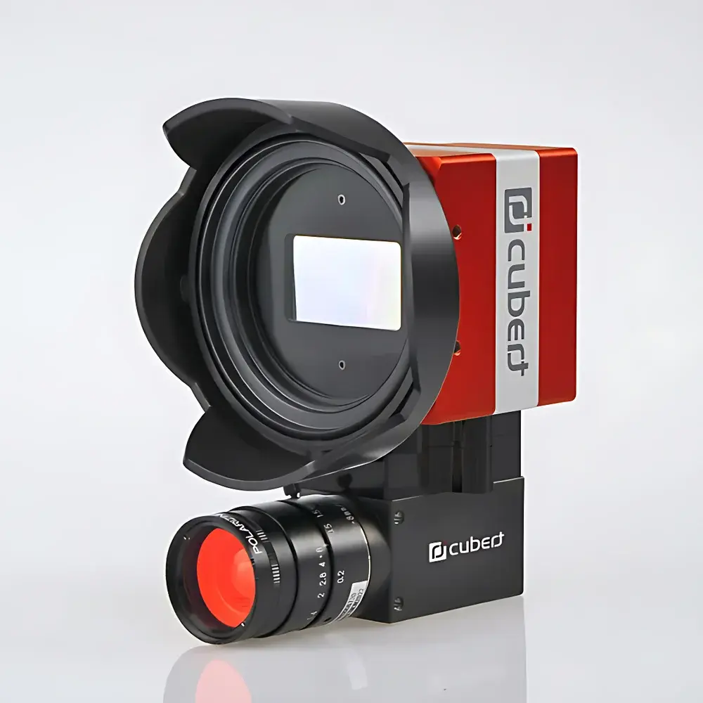
Cubert Ultris X20P Snapshot Hyperspectral Imaging System
| Brand | Cubert |
|---|---|
| Origin | Germany |
| Model | X20P |
| Spectral Range | 350–1000 nm |
| Spectral Resolution | 4 nm |
| Spatial Resolution (IFOV) | 0.018° |
| Field of View (TFOV) | 35° |
| Image Resolution | 1880 × 1880 pixels |
| Frame Rate | 8 cubes/s |
| Number of Spectral Bands | 163 |
| Weight | 630 g |
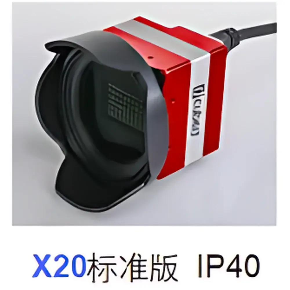
| IP Rating | IP40 |
| Operating Temperature | 0–65 °C |
| Power Supply | DC 12 V, 10 W |
| Dimensions | 100 × 100 × 60 mm |
| Detector | 20 MP Global Shutter CMOS |
| Bit Depth | 12-bit |
| Data Output | Dual GigE |
| GPS Triggering | Integrated |
Overview
The Cubert Ultris X20P is a snapshot-based hyperspectral imaging system engineered for high-fidelity, motion-artifact-free spectral data acquisition across airborne and ground-based platforms. Unlike scanning or push-broom hyperspectral systems—which require relative motion between sensor and target—the X20P captures full spatial-spectral data cubes in a single exposure using patented light-field hyperspectral architecture. This eliminates geometric misregistration, spectral smearing, and temporal inconsistencies inherent in line-scanning approaches, making it especially suitable for dynamic measurement scenarios including UAV-mounted remote sensing, laboratory-scale material characterization, and real-time vegetation monitoring. The instrument operates across the visible to near-infrared (VNIR) spectrum (350–1000 nm), resolving 163 contiguous spectral bands at 4 nm nominal resolution with ±0.5 nm wavelength accuracy. Its 20-megapixel global-shutter CMOS detector delivers native spatial resolution of 1880 × 1880 pixels per spectral layer, enabling high-fidelity spectral mapping without interpolation or resampling artifacts.
Key Features
- Snapshot acquisition: Full 163-band hyperspectral cube captured in one exposure—no moving optical components, no mechanical scanning.
- Dual-GigE interface: Enables sustained 8-cube-per-second streaming to host PC with low-latency, deterministic data transfer compliant with IEEE 802.3 standards.
- Light-field hyperspectral architecture: Integrates microlens array optics with high-quantum-efficiency CMOS to simultaneously encode spatial and spectral information within a single image plane.
- Ruggedized airborne design: IP40-rated enclosure; optimized mass distribution (630 g) and compact footprint (100 × 100 × 60 mm) for seamless integration on fixed-wing and multirotor UAVs.
- Integrated GPS triggering: Hardware-synchronized timestamping and georeferencing support precise geo-rectification in post-processing workflows.
- Real-time exposure control: Adjustable integration time from 0.1 ms to 1000 ms enables adaptation to varying illumination conditions—from overcast field surveys to controlled lab lighting.
Sample Compatibility & Compliance
The Ultris X20P supports non-contact, label-free analysis of heterogeneous surfaces ranging from plant canopies and soil substrates to manufactured composites and cultural heritage artifacts. Its VNIR spectral coverage aligns with established spectral absorption features of chlorophyll-a/b, carotenoids, water, cellulose, and nitrogenous compounds—making it compatible with ASTM E2922-22 (Standard Guide for Hyperspectral Imaging Data Collection) and ISO 17284-2:2021 (Remote Sensing — Vocabulary — Part 2: Hyperspectral Imaging). While not certified for regulated clinical or pharmaceutical use, its deterministic data capture, hardware-level timestamping, and reproducible calibration traceability support GLP-compliant environmental monitoring and agricultural research applications. All firmware and factory calibration files are stored onboard and digitally signed to ensure audit trail integrity.
Software & Data Management
The included Cubert HSI Studio software provides a validated workflow environment for radiometric correction, spectral unmixing, endmember extraction, and supervised/unsupervised classification. It supports ENVI-compatible BIL/BIP file formats and exports GeoTIFF with embedded projection metadata. Vegetation indices—including NDVI, EVI, PRI, and MCARI—are computed directly from calibrated reflectance cubes using standardized band math expressions per USDA ARS protocols. Raw data streams are recorded in lossless 12-bit format with embedded dark-frame and flat-field reference frames. Software logs include operator ID, acquisition timestamp, GPS coordinates, exposure settings, and sensor temperature—meeting minimum requirements for 21 CFR Part 11 audit trails when deployed in controlled research environments.
Applications
- Agricultural remote sensing: Crop health assessment, nutrient deficiency mapping, and precision irrigation planning via time-series spectral change detection.
- Environmental monitoring: Wetland delineation, invasive species identification, and post-fire regrowth tracking using spectral-temporal signatures.
- Geological surveying: Mineralogical mapping based on diagnostic absorption features in the 700–1000 nm region.
- Conservation science: Non-invasive pigment analysis of historical manuscripts and painted surfaces.
- Industrial quality control: Coating uniformity verification, polymer blend homogeneity assessment, and counterfeit detection in pharmaceutical packaging.
- Ecological phenotyping: High-throughput plant trait quantification in field-grown germplasm trials under natural illumination.
FAQ
Does the X20P require external calibration sources during operation?
No—factory-calibrated radiometric and spectral response curves are embedded in firmware and applied automatically during data reconstruction. Optional user recalibration kits (NIST-traceable reflectance panels and monochromatic light sources) are available for mission-critical validation.
Can the X20P be synchronized with other sensors (e.g., LiDAR or thermal cameras)?
Yes—via TTL trigger input/output ports and PPS-aligned GPS timestamps, enabling hardware-level synchronization with third-party payloads in multi-sensor UAV configurations.
Is raw data accessible for custom algorithm development?
Yes—HSI Studio exports unprocessed sensor frames (including dark and flat-field references) in HDF5 and TIFF formats, preserving full bit-depth and metadata for MATLAB, Python (scikit-image, spectral), or ENVI-based processing pipelines.
What UAV platforms have been validated for X20P integration?
Field-proven integrations include DJI Matrice 300 RTK, Quantum Systems Trinity F90+, and AZCW-10 VTOL; mechanical and electrical mounting templates are provided in the Integration Kit.
How is thermal drift managed during extended flight operations?
Internal temperature sensors feed real-time compensation into the radiometric correction pipeline; operating range (0–65 °C) covers typical UAV payload bay conditions without active cooling.