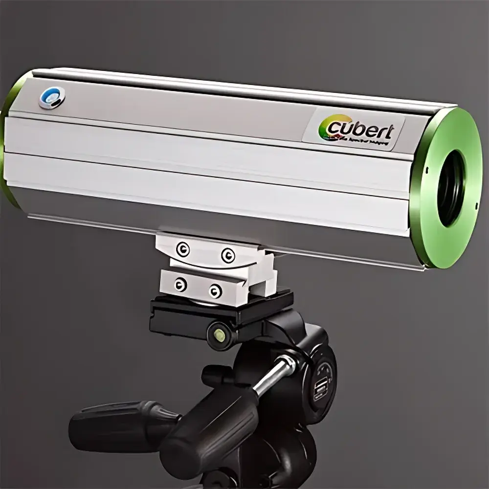
Cubert Q285 Snapshot Hyperspectral Imaging Spectrometer
| Brand | Cubert |
|---|---|
| Origin | Germany |
| Model | Q285 |
| Spectral Range | 450–950 nm |
| Spectral Resolution | 8 nm @ 532 nm |
| Spatial Resolution (IFOV) | Adjustable |
| Field of View (TFOV) | Interchangeable |
| Imaging Format | 1000 × 1000 pixels |
| Frame Rate | Up to 20 hyperspectral cubes per second |
| Detector | Dual Si-based area-scan CCD, 1 MP each |
| Spectral Sampling Interval | 4 nm |
| Bit Depth | 14-bit |
| Exposure Time | 0.1–1000 ms |
| Interface | Dual Gigabit Ethernet |
| Shutter Type | Global shutter |
| Optical Mount | C-mount |
| Lens Options | 10 mm / 23 mm / 35 mm Schneider lenses |
| IP Rating | IP67 |
| SDK | Open-source, C/C++ and Python compatible |
Overview
The Cubert Q285 is a snapshot-based, frame-integrated hyperspectral imaging spectrometer engineered for high-speed, motion-artifact-free spectral data acquisition in dynamic field and industrial environments. Unlike scanning-based systems (e.g., push-broom or whisk-broom architectures), the Q285 captures full 3D hyperspectral data cubes—comprising two spatial dimensions and one spectral dimension—in a single exposure using patented snapshot technology. This eliminates mechanical scanning, moving parts, and temporal misregistration between spectral bands, ensuring pixel-accurate co-registration across all 125 spectral channels. Its core optical architecture leverages dual synchronized silicon CCD sensors, each delivering 1000 × 1000 pixel resolution at 14-bit depth, enabling robust radiometric fidelity and high signal-to-noise ratio (SNR) within the 450–950 nm visible-to-near-infrared (VNIR) range. Designed for operational resilience, the instrument complies with IP67 environmental protection standards—fully dust-tight and capable of withstanding immersion in water up to 1 m for 30 minutes—making it suitable for unattended ground-based deployment, vehicle-mounted surveys, UAV-integrated payloads, and harsh outdoor conditions.
Key Features
- Snapshot acquisition: Captures complete 125-band hyperspectral cubes at up to 20 Hz without motion blur or spatial-spectral misalignment
- Dual high-resolution Si-CCD detectors: 1000 × 1000 pixels per sensor, global shutter operation, 14-bit digitization
- VNIR spectral coverage: 450–950 nm with 4 nm sampling interval and 8 nm FWHM resolution at 532 nm
- Ruggedized IP67 enclosure: Sealed against dust, water ingress, and mechanical shock—validated for long-term field stability
- C-mount optics interface: Compatible with interchangeable Schneider precision lenses (10 mm, 23 mm, 35 mm focal lengths)
- Dual GigE Vision-compliant interfaces: Enables high-throughput streaming (up to 2.5 Gbps per port) and deterministic synchronization with external triggers or GPS/IMU units
- Open software development kit (SDK): Fully documented C/C++ and Python APIs supporting real-time cube ingestion, calibration pipeline integration, and custom algorithm deployment
Sample Compatibility & Compliance
The Q285 is optimized for reflectance-based spectroscopic analysis of heterogeneous, time-varying surfaces—including vegetation canopies, agricultural produce, soil substrates, aqueous bodies, cultural heritage artifacts, and industrial conveyor-belt materials. Its snapshot modality ensures compatibility with rapidly moving or non-repeatable targets (e.g., flying drones, rotating machinery, flowing water). The system supports NIST-traceable radiometric calibration workflows and is routinely deployed in studies aligned with ISO 17025-accredited laboratories. While not certified as medical or safety-critical equipment, its hardware and firmware design adhere to IEC 61000-6-2/6-4 electromagnetic compatibility standards and RoHS 2011/65/EU material restrictions. Data provenance is preserved via embedded timestamping, sensor temperature logging, and metadata-enriched HDF5 or ENVI-compatible file outputs—facilitating audit readiness under GLP and ISO 14001 environmental monitoring frameworks.
Software & Data Management
The Q285 ships with Cubert’s proprietary HyperSpectra Suite—a modular desktop application for real-time visualization, geometric correction, atmospheric compensation (via empirical line or dark-reference methods), spectral library matching (using spectral angle mapper or Euclidean distance metrics), and vegetation index computation (NDVI, EVI, PRI, etc.). All processing modules are accessible programmatically through the open SDK, which includes prebuilt wrappers for SciPy, scikit-learn, and GDAL. Raw data is streamed directly into memory-mapped arrays or written to disk in vendor-neutral formats (e.g., BSQ, BIL, or NetCDF4), supporting integration with MATLAB, ENVI, QGIS, and custom machine learning pipelines. Audit trails—including acquisition parameters, calibration history, and user-defined annotations—are automatically recorded in JSON-formatted sidecar files compliant with FAIR (Findable, Accessible, Interoperable, Reusable) data principles.
Applications
- Remote sensing: Ground-based validation of satellite/airborne hyperspectral missions; phenotyping under natural illumination
- Precision agriculture: In-field detection of nutrient stress, disease onset, and irrigation deficits at sub-plot scale
- Environmental monitoring: Real-time characterization of algal blooms, suspended sediment load, and dissolved organic carbon in inland waters
- Food quality assurance: Non-destructive grading of fruit ripeness, bruise detection, and contaminant screening on production lines
- Cultural heritage science: Pigment identification, varnish degradation mapping, and underdrawing revelation in paintings and manuscripts
- Industrial process control: Composition verification of pharmaceutical granules, polymer blends, or recycled material streams
FAQ
What distinguishes snapshot hyperspectral imaging from push-broom systems?
Snapshot systems acquire all spectral bands simultaneously in a single exposure, eliminating motion-induced artifacts and enabling true video-rate hyperspectral capture. Push-broom systems require platform motion and sequential line-by-line scanning, introducing registration errors during vibration or acceleration.
Can the Q285 be integrated with GPS/IMU for georeferenced mapping?
Yes—its dual GigE interface supports hardware-synchronized triggering and timestamp alignment with external navigation units. Georeferencing is implemented post-acquisition using bundle adjustment or direct georeferencing workflows in third-party photogrammetry software.
Is factory calibration included, and how often is recalibration recommended?
Each unit ships with factory radiometric and spectral calibration certificates. Annual recalibration is recommended for quantitative applications; field recalibration using onboard white/dark references is supported via SDK.
Does the SDK support real-time GPU-accelerated processing?
The SDK provides low-level access to raw frame buffers, enabling integration with CUDA or OpenCL pipelines. Example implementations for real-time anomaly detection and spectral unmixing are provided in the developer documentation.
What lens options are validated for optimal MTF performance across the VNIR band?
Schneider-Kreuznach Xenoplan 1.4/10, Xenoplan 1.4/23, and Xenoplan 1.4/35 C-mount lenses are fully characterized and supplied with calibrated point-spread function (PSF) models for deconvolution-aware processing.
Related Products


")