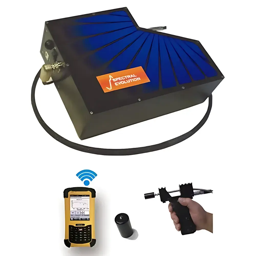
SEI SR-3501 Portable Field Spectroradiometer
| Brand | SEI |
|---|---|
| Origin | USA |
| Model | SR-3501 |
| Spectral Range | 280–2500 nm |
| Spectral Resolution | 4 nm (280–1000 nm), 7 nm @ 2100 nm, 9.5 nm @ 1500 nm |
| Detector Configuration | 512-pixel Si CCD (280–1000 nm), dual-stage cooled 256-pixel InGaAs arrays (970–1910 nm & 1900–2500 nm) |
| Spatial Sampling | Full-frame linear array, no moving optical components |
| FOV Options | 4°, 8°, 14° lenses |
| IFOV | Configurable via optics selection |
| Frame Rate | Up to 30 fps |
| Spectral Channels | 2151 |
| NEDL | 0.8×10⁻⁹ W/cm²/nm/sr @ 400 nm, 1.2×10⁻⁹ W/cm²/nm/sr @ 1500 nm, 1.8×10⁻⁹ W/cm²/nm/sr @ 2100 nm |
| Integration Time | 7.5–1000 ms |
| Wavelength Accuracy | ±0.5 nm |
| Wavelength Repeatability | ±0.1 nm |
| Calibration | NIST-traceable, factory-applied radiometric and spectral calibration |
| Interface | USB 2.0, Bluetooth 4.2 |
| Power | Removable 7.4 V Li-ion battery, >4 hours field operation |
| Dimensions | 21.6 × 29.2 × 8.9 cm (8.5″ × 11.5″ × 3.5″) |
| Weight | 3.3 kg (7.3 lbs) |
| Software | DARWin SP (Windows), DARWin CE Mobile (PDA/Getac PS236), USGS spectral library integration, vegetation index engine (NDVI, EVI, SAVI, PRI, WBI, GRVI, SR), CIE colorimetry, solar simulation, irradiance/reflectance/radiance quantification |
Overview
The SEI SR-3501 Portable Field Spectroradiometer is a high-fidelity, NIST-traceably calibrated instrument engineered for quantitative in-situ measurement of spectral reflectance, radiance, and irradiance across the ultraviolet–shortwave infrared (UV–SWIR) domain (280–2500 nm). Unlike scanning or filter-wheel spectrometers, the SR-3501 employs a fixed holographic grating coupled with three synchronized linear detector arrays—Si CCD (280–1000 nm), and two thermoelectrically cooled InGaAs stages (970–1910 nm and 1900–2500 nm)—to deliver simultaneous full-spectrum acquisition without mechanical movement. This architecture eliminates wavelength drift, slit misalignment, and grating repositioning errors common in monochromator-based systems, ensuring long-term radiometric stability and inter-session reproducibility essential for time-series field studies, validation of airborne/satellite sensors (e.g., Landsat, Sentinel-2, MODIS), and GLP-compliant environmental monitoring.
Key Features
- Triple-detector architecture: 512-pixel Si CCD + dual 256-pixel cooled InGaAs arrays enabling seamless UV–SWIR coverage with optimized quantum efficiency per band
- No moving optical parts: Fixed grating design ensures mechanical robustness, thermal stability, and immunity to vibration-induced calibration shift
- Integrated drift-lock auto-calibration: Real-time dark current subtraction and reference lamp stabilization mitigate thermal and temporal signal drift
- Modular optical interface: Interchangeable fore-optics—including 4°, 8°, and 14° field-of-view lenses, 25° fiber probes, and cosine-corrected integrating spheres—support diverse sampling geometries
- Wireless and wired control: Dual-mode operation via USB 2.0 or Bluetooth 4.2; compatible with Windows laptops and ruggedized PDAs (e.g., Getac PS236 with integrated GPS, digital camera, altimeter, and electronic compass)
- Lightweight aluminum chassis (3.3 kg): Precision-machined enclosure provides passive thermal regulation and EMI shielding while meeting MIL-STD-810G shock/vibration requirements for field deployment
- One-touch measurement protocol: Automated exposure optimization and spectral capture reduce operator dependency and standardize data acquisition across multi-user campaigns
Sample Compatibility & Compliance
The SR-3501 is designed for non-contact, non-destructive spectral characterization of natural and engineered surfaces under ambient illumination or controlled source conditions. It supports bidirectional reflectance distribution function (BRDF) measurements when paired with goniometric mounts, and enables absolute irradiance quantification using calibrated quartz-halogen or deuterium lamps. All factory calibrations are traceable to NIST Standard Reference Materials (SRMs) and documented per ISO/IEC 17025 requirements. The instrument complies with ASTM E275, E131, and E1477 for spectral measurement practice, and its software audit trail functionality—including user log, timestamped metadata, and immutable raw data export—supports FDA 21 CFR Part 11 and EU Annex 11 compliance for regulated environmental and agricultural research applications.
Software & Data Management
DARWin SP (Windows) and DARWin CE Mobile (PDA) provide unified acquisition, visualization, and preprocessing workflows. Raw spectra are stored in vendor-neutral .spc and .asd formats, with embedded EXIF-like metadata (GPS coordinates, UTC timestamp, FOV, integration time, detector temperature). The software integrates the USGS Spectral Library for mineral identification and includes an embedded vegetation index engine computing NDVI, EVI, SAVI, PRI, WBI, GRVI, SR, and 10+ additional indices compliant with FAO and NASA protocols. Spectral resampling tools enable direct comparison with satellite sensor bandpasses (e.g., Landsat OLI, Sentinel-2 MSI, MODIS). CIE color space conversion (XYZ, xyY, L*a*b*), solar spectral simulation (ASTM G173), and energy-integrated metrics (e.g., PAR, UV-A/B dose) are natively supported. All processing steps are logged and exportable for third-party analysis in ENVI, Python (NumPy/SciPy), or R.
Applications
- Remote sensing ground truthing: Validation of hyperspectral and multispectral satellite/airborne data products
- Plant phenotyping and stress detection: Chlorophyll, carotenoid, water content, and nitrogen estimation via spectral indices and derivative analysis
- Soil and mineral mapping: Discrimination of clay minerals, iron oxides, carbonates, and organic matter using diagnostic absorption features
- Environmental monitoring: Detection of algal blooms, oil spills, snow/ice impurities, and urban material classification
- Laboratory-grade field spectroscopy: Radiometric calibration transfer between lab and field environments
- Ecological and climate research: Long-term spectral time series for phenology, carbon sequestration, and land-cover change assessment
FAQ
What spectral calibration standards are applied to the SR-3501?
Each unit undergoes full-spectrum radiometric and spectral calibration at SEI’s ISO/IEC 17025-accredited facility using NIST-traceable sources, including FEL-standard lamps and certified reflectance standards. Calibration certificates include uncertainty budgets per ISO/IEC Guide 98-3.
Can the SR-3501 operate under variable ambient temperatures?
Yes—the aluminum housing provides passive thermal mass, and the cooled InGaAs detectors maintain stable dark current across –10°C to +45°C operating range. Internal temperature sensors feed real-time correction into the DARWin SP processing pipeline.
Is spectral data export compatible with ENVI or Python-based analysis pipelines?
Yes—raw and processed spectra export in ASCII, .spc, and .asd formats with complete header metadata. A documented Python API (seipy) is available for batch processing, spectral smoothing, index computation, and georeferencing.
Does the system support automated GPS-tagged transect measurements?
When used with the optional Getac PS236 PDA, the SR-3501 records synchronized position, altitude, heading, and spectral data at user-defined intervals or distance triggers, generating GIS-ready shapefiles and KML exports.
How is stray light and detector nonlinearity corrected?
Stray light correction uses empirical polynomial models derived from mercury-argon lamp line profiles. Nonlinearity compensation is applied per detector array using factory-measured pixel response curves, updated with each firmware revision.


