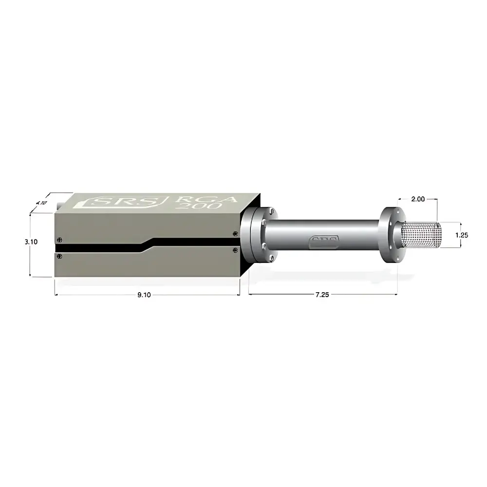
Cubert X20P IR Hyperspectral Imaging System
| Brand | Cubert |
|---|---|
| Origin | Germany |
| Model | X20P IR |
| Spectral Range | 350–1000 nm |
| Spectral Resolution | 1886 × 1886 pixels per cube |
| Spatial Resolution (IFOV) | 2 cubes/s, 1886 × 1886 pixels/cube |
| Frame Rate | 2 cubes/s, 1886 × 1886 pixels/cube |
| Field of View (TFOV) | ±50° pitch, ±90° roll |
| Imaging Modality | Dispersive (Snapshot Lightfield-based) |
| Platform Compatibility | Ground-based and airborne (UAV-integrated) |
| Integrated Detector | 640 × 512 uncooled microbolometer array for simultaneous thermal IR imaging |
Overview
The Cubert X20P IR Hyperspectral Imaging System is a snapshot-based, lightfield-engineered hyperspectral sensor designed for synchronized acquisition of visible–near-infrared (VNIR) spectral data and uncooled thermal infrared imagery. Unlike scanning or push-broom systems, the X20P IR employs a monolithic, single-shot lightfield architecture—enabling full 1886 × 1886 spatial-spectral datacubes to be captured at 2 Hz without motion-induced spectral misregistration. Its core optical design integrates a custom dispersive element with a dual-layer focal plane array: the top layer captures VNIR radiance across 350–1000 nm with high photon efficiency, while the underlying 640 × 512 microbolometer array simultaneously records thermal emission in the long-wave infrared (LWIR) band. This co-registered, temporally aligned dual-modality output supports quantitative analysis of both material reflectance signatures and surface temperature dynamics—critical for applications requiring physical state correlation, such as vegetation stress mapping, industrial process monitoring, or hazardous material detection.
Key Features
- Snapshot lightfield acquisition: No mechanical scanning or temporal interleaving—ensures pixel-level spectral–spatial fidelity under dynamic conditions.
- Dual-modality imaging: Simultaneous VNIR hyperspectral cubes (350–1000 nm) and LWIR thermal images (via integrated uncooled microbolometer) acquired in strict temporal synchronization.
- High-speed frame capture: Sustained 2 cubes/second output at native 1886 × 1886 spatial resolution per cube—optimized for UAV-mounted operation with minimal latency.
- Wide field-of-view flexibility: ±50° pitch and ±90° roll angular coverage enables full hemispherical scene capture from stabilized platforms, supporting oblique and nadir viewing geometries.
- Embedded processing & storage: Onboard FPGA-based control logic, real-time data compression, and solid-state storage eliminate reliance on external recording hardware—reducing SWaP-C (Size, Weight, Power, and Cost) for aerial deployment.
- Integrated brushless gimbal option: Factory-calibrated stabilization system with inertial measurement unit (IMU) fusion ensures geometric integrity during high-vibration flight regimes.
Sample Compatibility & Compliance
The X20P IR is engineered for non-contact, passive remote sensing of heterogeneous surfaces—including vegetative canopies, mineral outcrops, manufactured composites, and urban infrastructure. Its spectral calibration traceability follows ISO/IEC 17025-compliant procedures performed at Cubert’s certified metrology laboratory in Ulm, Germany. Radiometric accuracy is validated against NIST-traceable blackbody sources and calibrated reflectance panels (e.g., Spectralon®). The system meets CE marking requirements for electromagnetic compatibility (EMC Directive 2014/30/EU) and low-voltage safety (LVD Directive 2014/35/EU). For regulated environments—including environmental monitoring programs governed by EPA Method TO-15 or agricultural compliance under EU Regulation (EC) No 1107/2009—the X20P IR supports audit-ready metadata logging (GPS, IMU, exposure, integration time) compliant with FAIR data principles.
Software & Data Management
Cubert’s proprietary UHD-Analyzer software provides end-to-end workflow support—from raw cube ingestion and atmospheric correction (using MODTRAN-based radiative transfer modeling) to spectral unmixing (vertex component analysis), classification (SVM, Random Forest), and georeferenced orthomosaic generation. All processing modules are scriptable via Python API (PyCubert), enabling integration into automated QA/QC pipelines. Raw data is stored in HDF5 format with embedded GeoTIFF-compatible geolocation tags and full EXIF-style metadata—including GPS timestamp, IMU quaternion, and detector temperature logs. For GLP/GMP-aligned laboratories, optional FDA 21 CFR Part 11-compliant audit trail extension is available, enforcing electronic signature validation, user role-based access control, and immutable change history for all processing parameters.
Applications
- Agricultural phenotyping: Detection of early-stage water stress, nitrogen deficiency, and fungal infection via chlorophyll absorption features (680 nm), red-edge shift, and canopy temperature anomalies.
- Environmental remote sensing: Discrimination of invasive species, soil organic carbon estimation, and post-wildfire burn severity assessment using spectral indices (NDVI, NDMI, BSI) combined with thermal inertia modeling.
- Industrial quality assurance: Real-time identification of polymer degradation, coating delamination, or thermal hotspots in photovoltaic arrays and battery modules.
- Defense & security: Concealed object detection (e.g., buried IEDs via subsurface thermal contrast) and camouflage discrimination using spectral–thermal feature fusion algorithms.
- Geological surveying: Lithological mapping through diagnostic absorption bands (e.g., Al–OH at 2200 nm, Fe³⁺ at 860 nm) augmented by emissivity-constrained thermal mineral identification.
FAQ
Does the X20P IR require external cooling for the VNIR detector?
No—the VNIR sensor operates at ambient temperature; only the integrated microbolometer array requires thermoelectric stabilization, which is fully managed internally.
Can spectral calibration be performed in-field?
Yes—UHD-Analyzer supports on-site radiometric and spectral recalibration using portable integrating spheres and tunable LED sources, with traceability maintained via embedded calibration certificate hashes.
Is the system compatible with third-party UAV autopilots (e.g., Pixhawk, DJI SDK)?
Yes—serial and MAVLink protocol support enables bidirectional telemetry exchange, including trigger synchronization, gimbal angle feedback, and real-time health monitoring.
What is the maximum operational altitude for airborne use?
Certified for continuous operation up to 5,000 m ASL; performance validation includes pressure chamber testing at 50 kPa and thermal cycling from −20 °C to +60 °C.
How is geometric distortion corrected across the wide FOV?
Factory-derived polynomial distortion models (order ≥5) are applied during onboard preprocessing; residual errors are <0.3 pixels RMS when combined with RTK-GNSS and IMU-aided bundle adjustment in post-processing.
Related Products
")