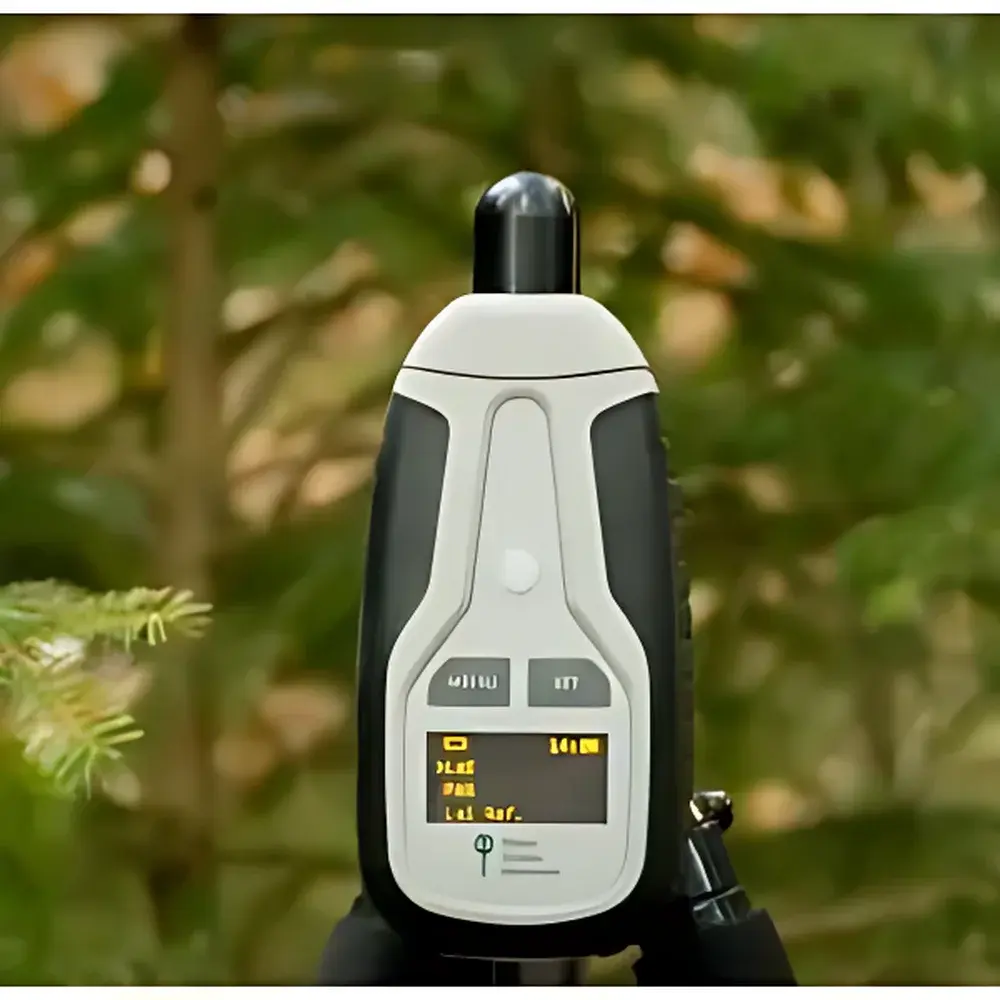
PSI LaiPen LP110 Leaf Area Index Meter
| Brand | PSI / Photon Systems Instruments |
|---|---|
| Origin | Czech Republic |
| Model | LaiPen LP110 |
| Category | Handheld Canopy Optical Sensor for LAI Estimation |
| Measurement Principle | Hemispherical Solar Radiation Attenuation Analysis |
| Operating Modes | Single-Sensor (manual reference) and Dual-Sensor (synchronous reference acquisition) |
| Compliance | Designed for field-deployable, non-destructive vegetation structural assessment in accordance with ISO 13837 (optical methods for plant canopy characterization) and FAO Agro-Meteorological Guidelines |
Overview
The PSI LaiPen LP110 Leaf Area Index Meter is a portable, optical field instrument engineered for rapid, non-destructive estimation of Leaf Area Index (LAI) in broadleaf canopies. LAI—defined as the one-sided green leaf area per unit ground surface area (m²·m⁻²)—serves as a fundamental biophysical parameter in ecosystem modeling, carbon flux analysis, remote sensing validation, and agronomic stress monitoring. Unlike traditional LAI instruments reliant on specific solar zenith angles or overcast conditions to minimize directional effects, the LaiPen LP110 employs a calibrated wide-angle optical sensor (180° field-of-view) to capture diffuse and direct solar radiation transmittance through the canopy at five discrete inclination angles. These multi-angle irradiance measurements are processed using an embedded vegetation radiation transfer model—based on the Beer–Lambert law and modified spherical canopy assumptions—to compute LAI with high reproducibility across variable sky conditions, including clear-sky, partly cloudy, and high-irradiance midday scenarios.
Key Features
- Optically optimized hemispherical sensor head with cosine-corrected photodiode and spectral response aligned to PAR (400–700 nm), minimizing angular and spectral errors in natural daylight
- Dual operational modes: single-sensor mode (user-performed sequential above- and below-canopy measurements) and dual-sensor mode (synchronized top- and bottom-canopy acquisition via two identical units, eliminating temporal drift)
- Onboard microprocessor with real-time LAI calculation engine; results displayed instantly on integrated LCD screen with timestamp, GPS-tagged metadata (when paired with external GNSS module)
- Rugged, weather-resistant housing (IP65-rated) suitable for extended field deployment in tropical, temperate, and boreal forest environments
- Battery-powered operation (rechargeable Li-ion, >12 hours continuous use); USB-C interface for firmware updates and data export in CSV format
- Calibration traceable to NIST-traceable irradiance standards; factory calibration certificate provided with each unit
Sample Compatibility & Compliance
The LaiPen LP110 is validated for use with homogeneous to moderately heterogeneous broadleaf canopies—including deciduous forests, agroforestry systems, vineyards, and herbaceous crop stands—where leaf angle distribution approximates random or planophile orientation. It is not recommended for needleleaf coniferous stands with high clumping indices or highly stratified multi-layered canopies without auxiliary correction factors. The instrument complies with ISO 13837:2006 “Plants — Determination of leaf area index — Optical methods” and supports GLP-aligned field data collection workflows. Its measurement protocol aligns with FAO’s CropWat and AquaCrop modeling frameworks and satisfies ground-truthing requirements for Sentinel-2 and Landsat surface reflectance product validation under CEOS LPV (Land Product Validation) guidelines.
Software & Data Management
Raw irradiance values and computed LAI outputs are stored internally (up to 10,000 measurements) and exportable via USB or Bluetooth (optional module). PSI provides the free LaiPen Manager desktop application (Windows/macOS) for batch processing, spatial interpolation, QA/QC flagging (e.g., outlier detection based on sky condition classification), and integration with GIS platforms (ESRI Shapefile, GeoJSON). The software supports audit trails, user-defined project metadata, and export formats compliant with FAIR (Findable, Accessible, Interoperable, Reusable) data principles. For regulated environments, optional 21 CFR Part 11-compliant configuration is available upon request—including electronic signatures, role-based access control, and immutable log files.
Applications
- Long-term monitoring of canopy development in ecological research plots and forest inventory networks
- Quantifying physiological stress responses to air pollutants (e.g., ozone, NO₂), drought, defoliation by pests or pathogens, and nutrient limitation
- Ground calibration and uncertainty quantification of satellite-derived LAI products (e.g., MOD15A2H, GEOV1, PROBA-V)
- Input parameterization for terrestrial biosphere models (e.g., ORCHIDEE, CLM5) and regional carbon budget assessments
- Supporting precision agriculture decisions via canopy closure metrics in row crops and orchards
- Training and validation datasets for machine learning models predicting LAI from UAV-based multispectral imagery
FAQ
Does the LaiPen LP110 require full cloud cover for accurate measurements?
No. Its multi-angle acquisition strategy and embedded radiative transfer algorithm compensate for direct beam influence, enabling reliable LAI estimation under clear-sky conditions—unlike fisheye-camera-based methods that require diffuse illumination.
Can it be used in coniferous forests?
Limited applicability. While usable in sparse or mixed stands, dense conifer canopies exhibit high leaf clumping and non-random architecture; users should apply species-specific correction factors or combine with destructive sampling for validation.
Is GPS positioning built-in?
No internal GNSS chip, but the device supports external Bluetooth GNSS receivers (e.g., Garmin GPS 19x, Emlid Reach RS2) for geotagging via the LaiPen Manager software.
How often does the instrument require recalibration?
PSI recommends annual verification against a reference irradiance source; field recalibration is not user-serviceable. A calibration due date is logged in device memory and flagged in the software dashboard.
What file formats does the exported data support?
CSV (tabular irradiance/LAI records), KML (georeferenced point layers), and XML (metadata-rich exchange format compatible with ICASA and Agronomy Ontology schemas).