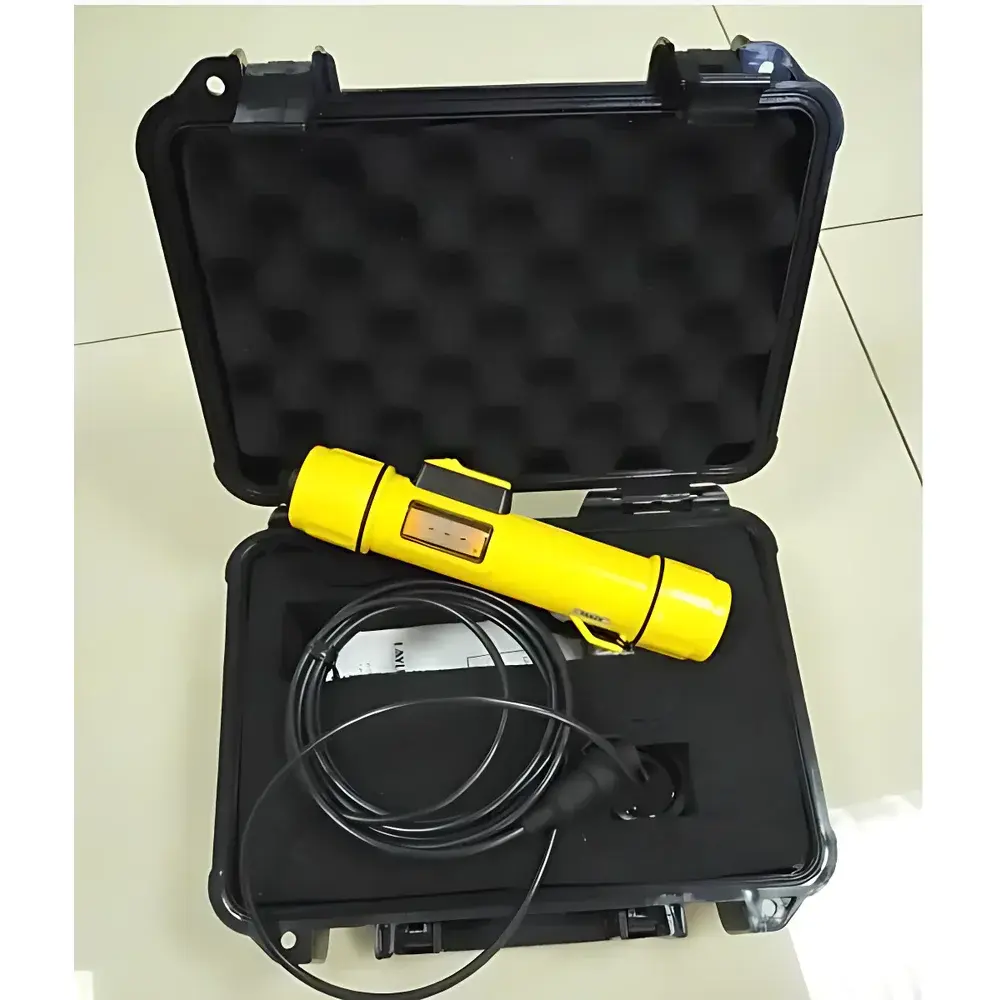
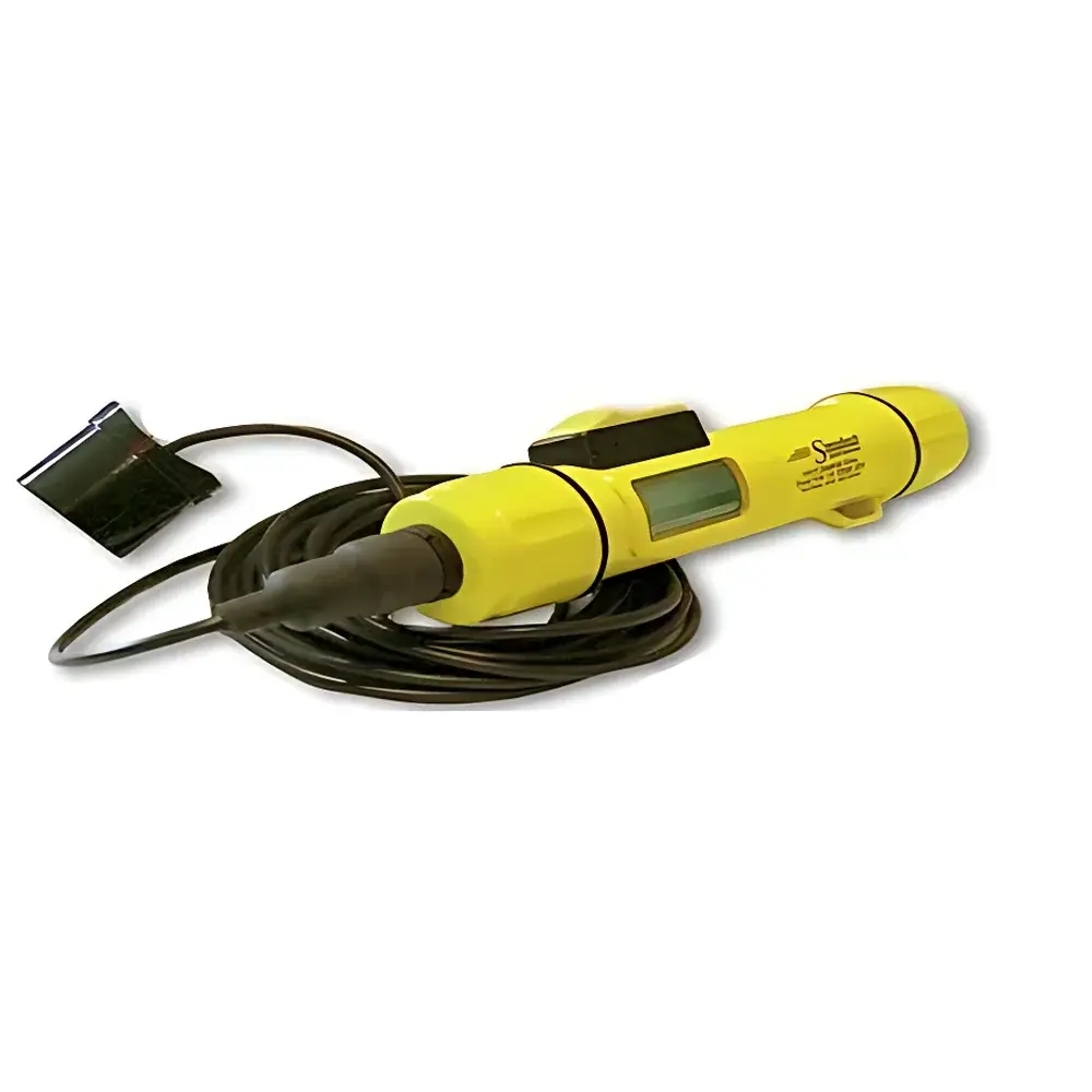
SPEEDTECH SM-5A Portable Echo Sounder
| Origin | Japan |
|---|---|
| Manufacturer Type | Authorized Distributor |
| Origin Category | Imported |
| Model | SM-5A |
| Price | USD 695 (FOB) |
| Depth Range | 0.6–79 m (2–260 ft) |
| Transducer Frequency | 200 kHz |
| Beam Angle | 6° (standard transducer) / 24° (optional wide-beam transducer) |
| Accuracy | ±0.1 m (±0.3 ft) |
| Waterproof Rating | IP67 (submersible to 50 m) |
| Display Hold Time | 10 s |
| Battery | 9 V alkaline (≥500 measurements at 10 s intervals) |
| Dimensions | 198 × 42 mm (7.7 × 1.7 in) |
| Weight | 300 g |
| Housing Color | High-visibility yellow |
Overview
The SPEEDTECH SM-5A Portable Echo Sounder is an ultrasonic depth measurement instrument engineered for field-deployable hydrographic surveying, ice fishing operations, bathymetric reconnaissance, and aquatic resource management. It operates on the principle of time-of-flight ultrasonic echo ranging: a 200 kHz transducer emits a short acoustic pulse vertically downward into the water column; the elapsed time between pulse transmission and return echo detection—reflected from the sediment-water interface or submerged hard bottom—is converted into depth using the known speed of sound in freshwater (~1480 m/s) and seawater (~1520 m/s). The device employs digital signal processing to suppress noise from surface turbulence, suspended particulates, and weak bottom returns, ensuring stable readings even under low-visibility conditions such as turbid water or black ice cover. Its compact, ergonomic form factor and high-visibility yellow housing meet ANSI/ISEA Z87.1 visibility standards for outdoor safety, while its IP67-rated enclosure guarantees reliable operation during submersion, rain exposure, or accidental drops into water.
Key Features
- High-precision single-beam echosounding with ±0.1 m depth resolution and repeatability within ±0.05 m under controlled conditions
- Dual-beam transducer compatibility: standard 6° narrow beam for high lateral resolution in deep or narrow channels; optional 24° wide beam for improved bottom detection in shallow, uneven, or vegetation-rich environments
- Real-time digital display with auto-hold function—depth value remains visible for exactly 10 seconds post-measurement to facilitate manual logging or visual verification
- Integrated temperature-compensated sound velocity algorithm, enabling consistent accuracy across varying water temperatures (0–30 °C)
- Ruggedized ABS polymer housing with over-molded rubber grip and corrosion-resistant stainless-steel transducer mount
- Low-power electronics architecture supporting >500 discrete depth measurements per 9 V alkaline battery at 10-second sampling intervals
Sample Compatibility & Compliance
The SM-5A is validated for use in freshwater lakes, rivers, reservoirs, estuaries, and nearshore marine environments. It complies with IEC 60529 (IP67 ingress protection), RoHS 2011/65/EU, and FCC Part 15 Class B electromagnetic compatibility requirements. While not certified for regulatory-grade bathymetric mapping under ISO 25862 or IHO S-44, it meets ASTM D6460-22 “Standard Practice for Determination of Water Depth Using Ultrasonic Sounders” for non-critical field estimation tasks. Its 200 kHz operating frequency provides optimal balance between penetration depth and resolution for depths up to 79 m—suitable for routine monitoring in aquaculture ponds, dam safety inspections, and pre-dredging site assessment. The device does not require calibration traceability to NIST or PTB standards but includes factory-set zero-offset correction verified against certified depth gauges prior to shipment.
Software & Data Management
The SM-5A operates as a standalone field instrument with no onboard data logging or Bluetooth/Wi-Fi connectivity. All measurements are intended for direct visual readout and manual recording. However, its consistent output format (depth in meters or feet, user-selectable via toggle switch) enables seamless integration into third-party GIS or spreadsheet workflows. Users may document location-stamped observations using companion mobile applications (e.g., QGIS Field Maps or Fulcrum) alongside concurrent GPS coordinates. For audit-ready documentation, the unit supports GLP-aligned procedural logging: each measurement session can be annotated with operator ID, date/time stamp (via external logbook), environmental notes (e.g., ice thickness, water clarity), and transducer orientation (vertical vs. angled deployment). No firmware updates or driver installation is required—no software dependencies exist.
Applications
- Aquatic habitat assessment: profiling littoral zone topography and identifying submerged structures for fisheries biologists
- Ice safety verification: non-invasive depth validation beneath black ice prior to pedestrian or vehicular access
- Small vessel navigation support: real-time shallow-water hazard detection for kayaks, canoes, and inflatable boats
- Environmental monitoring: tracking seasonal sediment accumulation in retention basins and stormwater ponds
- Educational fieldwork: undergraduate hydrology labs requiring portable, intuitive depth instrumentation
- Infrastructure inspection: rapid verification of scour depth around bridge piers, culvert outlets, and riprap installations
FAQ
What is the maximum operational depth of the SM-5A?
The device measures reliably from 0.6 m to 79 m (2–260 ft) in freshwater with typical bottom reflectivity. Performance may degrade in highly absorptive media (e.g., hypersaline brines) or over soft, acoustically dampening sediments.
Can the SM-5A be used through ice?
Yes—it is routinely deployed through drilled holes in black ice. The 200 kHz beam penetrates ice up to 1.2 m thick when coupled with water-based gel; accuracy remains within specification provided the ice-water interface is free of air pockets or snow melt layers.
Is the transducer replaceable or upgradeable?
The standard transducer is permanently potted and non-user-serviceable. Optional wide-beam (24°) transducers are available as factory-installed configurations—not field-swappable modules.
Does the SM-5A meet FDA or EPA reporting requirements?
No. It is not designed for regulated environmental compliance reporting (e.g., EPA Method 1622), nor does it generate 21 CFR Part 11-compliant electronic records. It serves strictly as a field estimation tool.
How is unit consistency maintained across multiple instruments?
Each unit undergoes end-of-line acoustic calibration against a reference depth tank traceable to NPL-accredited standards. A unique serial-numbered calibration certificate is supplied with every device, listing measured offset values at 5, 20, and 60 m test points.
Related Products


