AERO Aero LF Ground Penetrating Radar System
| Brand | AERO |
|---|---|
| Origin | Beijing, China |
| Manufacturer Type | Authorized Distributor |
| Region of Manufacture | Domestic (China) |
| Model | Aero LF |
| Price | USD 81,200 (approx.) |
| Weight | 1.0 kg (300 MHz antenna), 1.2 kg (150 MHz antenna), 1.4 kg (75 MHz antenna) |
| Operating Temperature | −20 °C to +60 °C |
| Dynamic Range | 0–168 dB |
| Sampling Rate | up to 1,280,000 samples per second |
| Scan Rate | up to 2,500 scans per second (configuration-dependent) |
| Penetration Depth | 10–12 m (soil-dependent) |
| Data Resolution | 32-bit raw digital output |
| Real-time Terrain Following Capability | Yes (with optional altimeter integration) |
Overview
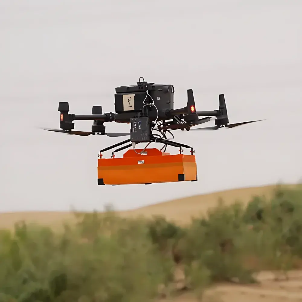
The AERO Aero LF Ground Penetrating Radar (GPR) system is an ultra-lightweight, multi-platform geophysical imaging instrument engineered specifically for unmanned aerial vehicle (UAV) deployment—particularly compatible with DJI Matrice 300 RTK and AERO A6 series platforms—while retaining full operational flexibility for ground-based, vehicle-mounted, or marine survey configurations. Based on impulse radar technology operating in the low-frequency band (75–300 MHz), the Aero LF employs time-domain electromagnetic wave propagation principles: it transmits short-duration UWB pulses into subsurface media and records reflected signals at high temporal resolution. Dielectric contrast between materials (e.g., soil/rock, voids, metallic objects, ice layers, or buried utilities) governs reflection amplitude and travel time, enabling depth-resolved stratigraphic reconstruction. Its compact architecture, sub-1.4 kg mass across all antenna variants, and wide operational temperature range (−20 °C to +60 °C) make it suitable for field-intensive campaigns in alpine, arid, periglacial, and urban environments where logistical constraints preclude traditional towed or hand-pushed GPR systems.
Key Features
- Modular antenna design supporting rapid interchange of 75 MHz, 150 MHz, and 300 MHz shielded antennas—optimized for trade-offs between penetration depth and vertical resolution
- Real-time terrain-following capability via integrated barometric altimeter and optional LiDAR-assisted height control; enables stable flight at 1 m AGL with ≤2 cm vertical accuracy for consistent near-surface sampling geometry
- High-fidelity data acquisition engine delivering up to 1,280,000 samples per second and 2,500 scans per second—ensuring dense spatial sampling even at UAV cruise speeds exceeding 8 m/s
- 32-bit raw data capture with 0–168 dB dynamic range, preserving signal integrity for post-processing workflows including migration, gain compensation, and synthetic aperture radar (SAR) focusing
- Ruggedized housing rated IP67 for dust/water resistance; compliant with MIL-STD-810G shock and vibration requirements for airborne deployment
- Low-power consumption design compatible with standard UAV battery systems (24–58 V DC input)
Sample Compatibility & Compliance
The Aero LF is validated for use across heterogeneous subsurface media—including dry sand, glacial till, loam, frozen soils, freshwater ice, and asphalt-concrete pavements—subject to site-specific dielectric permittivity and conductivity conditions. It complies with international electromagnetic compatibility standards IEC 61000-6-3 (emissions) and IEC 61000-6-2 (immunity). While not certified under specific regulatory frameworks such as FDA or ISO 13485 (as it is a geophysical tool, not a medical device), its raw data format and metadata structure adhere to the SEG-Y Rev. 2.0 specification for seismic/GPR data interchange. All firmware and acquisition software support audit-trail logging required for GLP-compliant environmental site assessments and infrastructure inspection reporting.
Software & Data Management
Data acquisition is managed through AERO’s proprietary GPR Studio software suite, which supports real-time preview, GPS-synchronized trace tagging, and onboard storage via removable microSDXC cards (up to 1 TB). Post-processing tools include automatic gain control (AGC), background subtraction, FK filtering, velocity analysis using common-midpoint (CMP) gathers, and 2D/3D migration algorithms. Export formats include SEG-Y, ASCII XYZ, GeoTIFF, and LAS for interoperability with GIS platforms (QGIS, ArcGIS), CAD modeling tools (AutoCAD Civil 3D), and photogrammetry pipelines (Pix4D, Agisoft Metashape). Software updates are delivered via secure HTTPS channel with SHA-256 signature verification; configuration files are digitally signed to prevent unauthorized modification.
Applications
- Glaciological studies: Mapping internal ice layering, crevasse detection, and basal interface characterization in alpine and polar glaciers
- Permafrost and snowpack monitoring: Quantifying snow water equivalent (SWE), identifying ice lenses, and detecting talik zones
- Civil infrastructure assessment: Locating subsurface voids, tunnel linings, utility conduits, and pavement delamination beneath roads and runways
- Archaeogeophysical prospection: Non-invasive mapping of buried walls, foundations, and anthropogenic features without excavation
- Environmental site investigation: Delineating contaminant plumes, landfill boundaries, and buried drums in brownfield redevelopment projects
- Disaster response: Rapid assessment of landslide slip surfaces, sinkhole precursors, and post-earthquake foundation integrity
- Defense and security operations: Detection of shallow-buried explosive hazards, unexploded ordnance (UXO), and clandestine tunnels
FAQ
What UAV platforms are officially supported?
The Aero LF is validated for integration with DJI Matrice 300 RTK and AERO A6 series drones. Payload mounting kits, power distribution modules, and CAN/UART communication interfaces are provided with full documentation.
Is real-time kinematic (RTK) positioning supported?
Yes—the system accepts external GNSS input via UART or USB-C, supporting concurrent GPS, GLONASS, BeiDou, and Galileo constellations with RTK correction streams (e.g., NTRIP over LTE or radio link).
Can raw data be processed with third-party software?
Yes. SEG-Y Rev. 2.0 export preserves full trace headers, sample intervals, and coordinate metadata, enabling compatibility with ReflexW, GPR-Slice, and commercial geoscience platforms such as Petrel and Kingdom.
What is the typical achievable vertical resolution at 10 m depth?
At 150 MHz center frequency in typical loamy soil (εr ≈ 15), theoretical vertical resolution is ~0.3 m; actual resolution depends on signal-to-noise ratio, migration processing, and subsurface heterogeneity.
Does the system meet export control regulations?
The Aero LF falls under EAR99 classification per U.S. Export Administration Regulations (EAR); no license is required for most destinations, though end-use restrictions apply for military applications in embargoed countries.


