AERO SE-40/70/150 Airborne Ground Penetrating Radar System
| Brand | AERO |
|---|---|
| Origin | Sweden |
| Model | SE-40/70/150 |
| Center Frequencies | 52 MHz / 80 MHz / 124 MHz |
| Frequency Ranges | 15–105 MHz / 20–140 MHz / 20–280 MHz |
| Dynamic Range | 192 dB (32-bit) |
| Time Window | 0–1600 ns |
| Sampling Interval | 3.125 ns (320 MHz) |
| Stacking Rate | 32,000 traces/sec (45 dB SNR improvement) |
| Pulse Repetition Frequency | 156 kHz |
| Max Penetration Depth (Airborne/Ground/Freshwater) | 15/30/— m |
| Vertical/Horizontal Resolution | 48/141 cm |
| Operating Temperature | −20 °C to +50 °C |
| Dimensions (L×W×H) | 200×15×21 cm / 139×15×21 cm / 92×22×21 cm |
| Weight | 5.8 kg / 4.9 kg / 4.6 kg |
| UAV Payload Requirement | ≥6 kg / ≥5 kg / ≥5 kg |
Overview
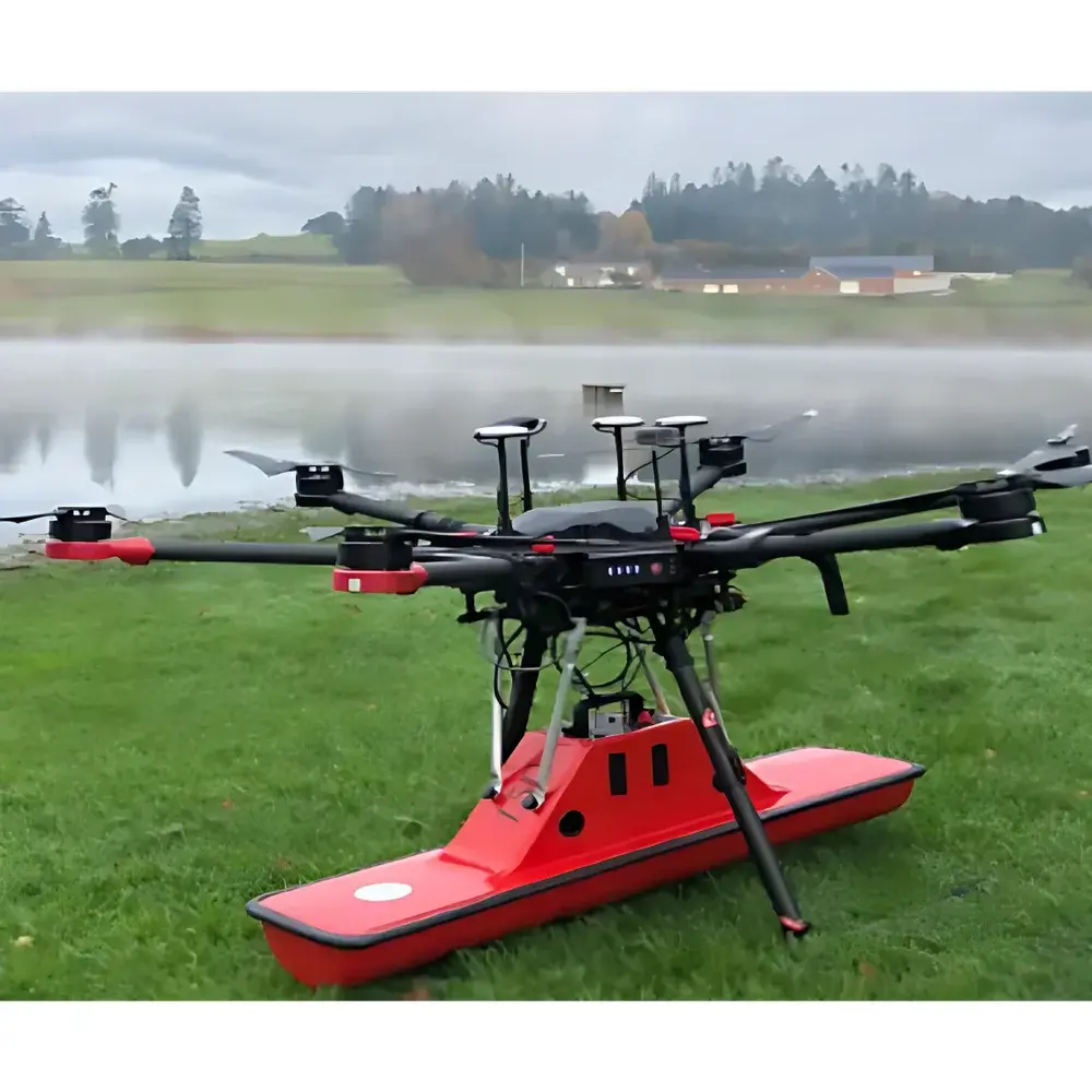
The AERO SE-40/70/150 is a modular, high-performance airborne ground penetrating radar (GPR) system engineered for geophysical surveying from unmanned aerial platforms. Based on ultra-wideband pulse transmission and time-domain reflectometry principles, it transmits short electromagnetic pulses into subsurface media and records the amplitude and travel time of reflected signals to reconstruct stratigraphic interfaces, buried objects, voids, or material discontinuities. Its tri-band architecture—comprising interchangeable SE-40 (52 MHz), SE-70 (80 MHz), and SE-150 (124 MHz) antennas—enables mission-specific optimization across shallow-high-resolution to deep-penetration surveying regimes. Designed for integration with medium-to-heavy-lift UAVs, the system maintains full synchronization between radar acquisition, inertial navigation (IMU), and GNSS positioning to ensure georeferenced data integrity under dynamic flight conditions. The host unit features a 32-bit analog-to-digital converter with 192 dB dynamic range and real-time stacking at up to 32,000 traces per second—critical for achieving high signal-to-noise ratio in low-SNR environments such as glacial ice, saturated sediments, or urban infrastructure.
Key Features
- Modular antenna platform supporting rapid field-swappable SE-40, SE-70, and SE-150 units—each calibrated for factory-traceable amplitude and phase response
- Ultra-stable pulse generator with 156 kHz repetition rate and sub-nanosecond rise time, optimized for coherent stacking and multi-offset migration processing
- Integrated time-synchronized data acquisition: simultaneous capture of radar traces, IMU orientation (roll/pitch/yaw), and PPS-locked GNSS position (RTK or PPK capable)
- Real-time onboard stacking (up to 32,000 traces/sec) with adaptive gain control and automatic noise floor estimation
- Ruggedized enclosure rated IP65; operational across −20 °C to +50 °C ambient range without active thermal management
- Lightweight mechanical design: host unit (5.8 kg) and antennas (4.6–4.9 kg) compliant with common commercial UAV payload constraints (≥5 kg minimum lift capacity)
Sample Compatibility & Compliance
The SE-40/70/150 system is validated for use across heterogeneous dielectric media—including dry sand, clay-rich soils, freshwater ice, snowpack, asphalt/concrete pavements, and fractured bedrock—provided relative permittivity remains within typical GPR operational bounds (εr = 3–30). Antenna selection directly governs depth–resolution trade-offs: SE-40 delivers optimal penetration (>30 m in dry loam) for regional geological mapping; SE-70 balances resolution and depth for utility detection and permafrost profiling; SE-150 provides centimeter-scale vertical resolution for pavement layer analysis and forensic excavation support. All configurations comply with EU EMC Directive 2014/30/EU and Radio Equipment Directive 2014/53/EU. Emission profiles conform to EN 301 489-1 and EN 300 328 for unlicensed UWB operation in the 15–280 MHz band. Data provenance meets GLP-aligned metadata logging requirements, including traceable UTC timestamps, sensor calibration IDs, and environmental telemetry.
Software & Data Management
Data acquisition is managed via DAQ software—a deterministic, low-latency application supporting real-time preview, trigger synchronization, and lossless binary trace export (IEEE 754 32-bit float format). Post-processing is performed in PRISM, a domain-specific platform offering advanced migration algorithms (Kirchhoff, reverse-time), gain compensation (AGC, spherical divergence), background removal (dewow, FK filtering), and attribute extraction (amplitude envelope, coherence, velocity analysis). PRISM supports ASTM D6432-compliant report generation, includes built-in tools for depth conversion using user-defined velocity models, and exports georeferenced raster and vector outputs (GeoTIFF, Shapefile, LAS) compatible with GIS and CAD workflows. Audit trails, user access logs, and electronic signatures are available to satisfy FDA 21 CFR Part 11 and ISO/IEC 17025 documentation requirements.
Applications
- Glaciology and permafrost monitoring: mapping internal ice layers, englacial conduits, and talik geometry beneath Arctic tundra
- Civil infrastructure assessment: non-destructive evaluation of bridge decks, tunnel linings, and railway ballast condition
- Environmental site characterization: delineation of contaminant plumes, landfill boundaries, and buried drums in brownfield remediation
- Archaeological prospection: detection of buried walls, foundations, and burial chambers without excavation
- Military and humanitarian demining: identification of anti-tank and anti-personnel mines in sandy or loamy soils
- Hydrogeology: aquifer geometry mapping, bedrock topography reconstruction, and sediment thickness estimation in alluvial basins
FAQ
What UAV platforms are certified for integration with the SE-40/70/150 system?
The system is mechanically and electrically compatible with any UAV meeting minimum payload capacity (≥5 kg for SE-70/SE-150; ≥6 kg for SE-40), vibration damping specifications (ISO 5344 Class B), and power delivery (24–36 V DC, ≥150 W sustained). Integration kits—including gimbal mounts, CAN/RS-422 interface modules, and GNSS-IMU fusion firmware—are available for DJI Matrice 300 RTK, Freefly Alta X, and senseFly eBee X platforms.
Does the system support real-time kinematic (RTK) positioning?
Yes—both DAQ and PRISM fully support dual-frequency GNSS receivers with RTK or post-processed kinematic (PPK) correction inputs. Sub-centimeter horizontal accuracy (<2 cm RMS) and <5 cm vertical accuracy are achievable when paired with CORS networks or base station solutions.
Can raw GPR data be exported for third-party processing?
All acquired traces are stored in open-format binary files (.gpr) accompanied by XML metadata containing antenna parameters, timing calibration, and sensor configuration. These files are natively readable by ReflexW, GPR-Slice, and custom Python/Matlab toolchains using the documented header structure.
Is factory recalibration required after field antenna swaps?
No—each antenna module contains embedded EEPROM storing its unique transfer function, time-zero offset, and gain coefficients. The host automatically loads these parameters upon physical connection, ensuring measurement continuity without manual intervention.
What is the recommended maintenance interval for long-term field deployment?
AERO recommends annual verification of timebase stability, ADC linearity, and antenna impedance matching using NIST-traceable test equipment. Full system recalibration is advised every 24 months or after exposure to shock events exceeding 50 g peak acceleration.


