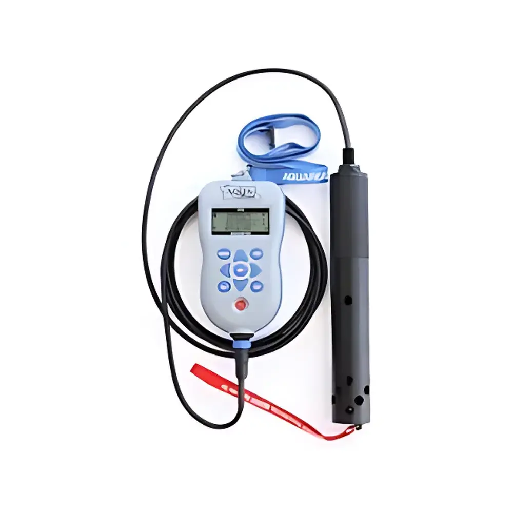
Aquaread AP-2000 GPS Portable Multiparameter Water Quality Meter
| Brand | Aquaread |
|---|---|
| Origin | United Kingdom |
| Model | AP-2000 |
| Measurement Parameters (Standard) | Optical Dissolved Oxygen, pH, ORP, Electrical Conductivity (EC), Temperature |
| Optional Add-ons | One Ion-Selective Electrode (e.g., NH₄⁺, NH₃-N, Cl⁻, F⁻, NO₃⁻, Ca²⁺) + One Optical Sensor (e.g., Chlorophyll-a, Phycocyanin, Turbidity, Hydrocarbon/Oil-in-Water) |
| Depth Measurement | Available in AP-2000-D variant with integrated pressure-based depth sensor |
| Data Logging | Onboard memory via Aquaread Logger software |
| GPS Integration | Built-in high-sensitivity GPS module with WGS84 coordinate output |
| Data Visualization | Export-compatible with Google Maps and Google Earth (KML/KMZ) |
| Compliance Context | Designed for field-deployable environmental monitoring per ISO 5667 (water sampling), ASTM D3370 (field measurement practices), and EPA Method 160.1 (pH/EC/DO field protocols) |
Overview
The Aquaread AP-2000 GPS Portable Multiparameter Water Quality Meter is an engineered field instrument designed for rapid, reliable, and spatially referenced in-situ assessment of freshwater, groundwater, wastewater, and estuarine systems. Based on a modular sensor architecture, the AP-2000 employs optical sensing technology for dissolved oxygen (luminescence-based quenching principle), glass-electrode pH measurement, platinum redox electrode for ORP, four-electrode conductivity cell for EC, and high-stability thermistor for temperature compensation — all calibrated to NIST-traceable standards. Its integrated GPS receiver provides sub-3-meter horizontal accuracy (CEP) under open-sky conditions, enabling georeferenced data collection essential for longitudinal site tracking, regulatory reporting, and GIS-integrated environmental mapping. The device operates within a ruggedized, IP68-rated housing rated for continuous submersion up to 20 m (AP-2000-D variant includes a calibrated pressure transducer for depth profiling), making it suitable for wade-in, boat-based, and shallow-borehole deployments without auxiliary flotation or tethering.
Key Features
- Modular sensor platform supporting simultaneous real-time measurement of five core parameters: optical DO, pH, ORP, EC, and temperature
- Expandable architecture accepting one additional ion-selective electrode (ISE) — configurable for NH₄⁺, NH₃-N, Cl⁻, F⁻, NO₃⁻, or Ca²⁺ — and one interchangeable optical probe (e.g., chlorophyll-a fluorescence, phycocyanin for cyanobacteria detection, Formazin Turbidity Units, or hydrocarbon-specific absorbance)
- Built-in high-sensitivity GPS module compliant with GPS/Galileo dual-constellation reception; outputs latitude, longitude, altitude, and UTC timestamp synchronized with each measurement
- Aquaread Logger software enables local data storage (up to 1 million readings), user-defined sampling intervals (1 sec–24 hr), and automatic metadata tagging (operator ID, site code, notes)
- Field-ready interface via Aquaread Aquameter handheld display unit — backlit LCD, tactile keypad, and intuitive menu navigation optimized for gloved operation
- Robust mechanical design: polycarbonate/ABS composite body, corrosion-resistant stainless-steel sensor mounts, and operating temperature range of –10 °C to +50 °C
Sample Compatibility & Compliance
The AP-2000 is validated for use across diverse aquatic matrices including low-conductivity upland streams (≥10 µS/cm), saline estuaries (<45 mS/cm), anaerobic groundwater (redox potential < –200 mV), and municipal wastewater effluents. Sensor response times meet ISO 5814 (DO), ISO 7888 (pH), and ISO 7887 (turbidity) performance benchmarks. All calibration procedures follow documented SOPs aligned with ISO/IEC 17025 requirements for field instrumentation. Data integrity supports GLP-compliant workflows through audit-trail-capable logging (user login, calibration history, flagging of out-of-range values). While not certified as 21 CFR Part 11 compliant out-of-the-box, raw CSV/KML exports are compatible with validated LIMS and ELN platforms used in regulated environmental laboratories.
Software & Data Management
Data acquisition and post-processing rely on Aquaread’s cross-platform desktop software (Windows/macOS), which imports binary .aqd files from the Logger. Functions include automated sensor diagnostics, multi-point calibration curve generation (linear/nonlinear), unit conversion (e.g., µS/cm ↔ dS/m, mg/L O₂ ↔ % saturation), and QA/QC flagging (e.g., temperature-compensated EC drift > ±2%). Geospatial outputs conform to KML 2.2 schema, enabling direct overlay in Google Earth Pro or integration into ArcGIS via standard import tools. Batch export options support EPA-required formats (e.g., CSV with header rows compliant with STORET template conventions) and custom report generation (PDF/Excel) with embedded site maps and time-series plots.
Applications
- Routine ambient water quality surveillance under national monitoring programs (e.g., EU WFD Article 8, US Clean Water Act Section 305(b))
- Pre- and post-remediation assessment of contaminated sites, including landfill leachate plume delineation and mine drainage characterization
- Algal bloom early-warning surveys using concurrent chlorophyll-a and phycocyanin measurements to differentiate cyanobacterial dominance
- Wastewater treatment plant influent/effluent compliance checks against discharge permits (e.g., NH₄⁺, NO₃⁻, turbidity limits)
- Groundwater vulnerability studies requiring precise vertical profiling (enabled by AP-2000-D depth sensor and optional down-hole deployment kit)
- Educational field labs where GPS-tagged datasets support spatial statistics instruction and watershed modeling exercises
FAQ
What is the maximum operational depth for the AP-2000 base model?
The standard AP-2000 is rated IP68 for immersion up to 20 meters; however, depth measurement requires the AP-2000-D variant with integrated pressure sensor.
Can multiple ISEs be used simultaneously?
No — the system supports only one ISE channel at a time due to signal isolation and calibration protocol constraints.
Is sensor recalibration required after every field deployment?
Field recalibration is recommended before each sampling campaign using certified buffer standards; drift verification checks are advised mid-campaign for critical parameters like pH and DO.
Does the GPS module function indoors or under dense canopy?
GPS signal acquisition is degraded under canopy or built environments; for such conditions, users should pre-load waypoints and rely on dead reckoning between fixes.
How is data security managed during transfer from Logger to PC?
Data transfer occurs via encrypted USB connection; no cloud transmission is performed by default, preserving data sovereignty per GDPR and local environmental data governance policies.