AZ ENVIdata-SFL Digital Networked In-Situ Lysimeter System for Actual Evapotranspiration Measurement in Watersheds
| Brand | AZ (Beijing Aozuo) |
|---|---|
| Origin | Germany |
| Manufacturer Type | Manufacturer |
| Origin Category | Imported |
| Model | ENVIdata-SFL |
| Instrument Type | Soil Moisture / Matric Potential Analyzer |
Overview
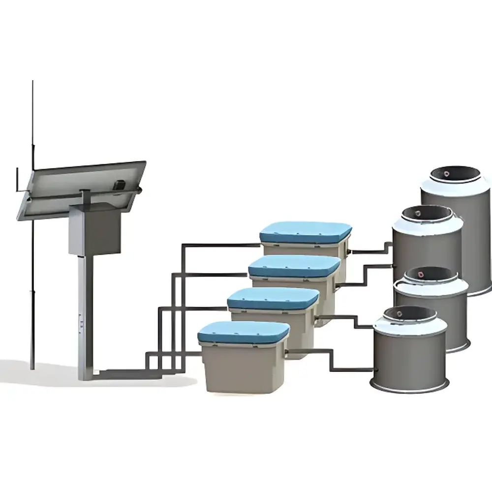
The AZ ENVIdata-SFL Digital Networked In-Situ Lysimeter System is an engineered field-scale instrumentation platform designed for continuous, high-temporal-resolution measurement of actual evapotranspiration (ETa) within hydrological watersheds. It operates on the principle of precision mass balance monitoring using stainless-steel monolith lysimeters—intact soil columns installed in situ to preserve natural soil structure, root architecture, and hydraulic continuity. Each lysimeter integrates bottom-mounted high-resolution load cells (±0.1 g repeatability), calibrated soil water potential sensors (tensiometric and/or electrical resistance-based), soil temperature probes, and optional drainage collection vessels. Real-time weight change (ΔW) is recorded at user-defined intervals (e.g., 5–30 min), enabling direct calculation of ETa via mass loss corrected for precipitation (P), deep percolation (Sw), and changes in soil water storage (ΔM). The system supports both standalone operation and synchronized multi-node deployment across upstream, midstream, and downstream watershed zones—ensuring spatial representativeness while maintaining metrological traceability to SI units (mm, kPa, °C, g). Its design aligns with ISO 16478:2014 (soil physics—field lysimetry) and supports compliance with FAO-56 and ASCE-EWRI standardization frameworks for evapotranspiration estimation.
Key Features
- Stainless-steel monolith lysimeter body (customizable height/diameter) with integrated water potential control chamber at base to maintain lateral hydraulic equilibrium between column interior and surrounding undisturbed soil.
- Distributed sensor array: Multi-depth soil water potential (matric potential range: −10 to −1000 kPa), volumetric water content (0–100% v/v), and soil temperature (−20 to +60 °C) with factory calibration certificates.
- High-stability load cell system (capacity: 50–500 kg; resolution: ≤0.05 g) housed in thermally insulated base enclosure to minimize thermal drift and mechanical vibration artifacts.
- Embedded data logger with dual-mode connectivity: RS-485/SDI-12 for local sensor interfacing and LTE-M/NB-IoT wireless uplink for remote data transmission to cloud-based dashboards or institutional servers.
- Field-deployable protective housing with IP67-rated enclosures, solar-rechargeable power management (12 V DC, 20 Ah battery + 20 W PV panel), and frost-resistant mounting hardware for year-round operation in temperate and cold-climate watersheds.
Sample Compatibility & Compliance
The ENVIdata-SFL system accommodates undisturbed soil monoliths from diverse pedological classes—including loam, clay, sandy loam, and organic-rich histosols—without requiring soil homogenization or repacking. Sensor placement follows ASTM D5859-22 (Standard Guide for Installation of Soil Water Sensors) and ISO 22042:2021 (Soil quality—determination of soil water retention characteristics). All electronic components comply with IEC 61326-1 (EMC requirements for laboratory and industrial use) and CE/FCC regulatory directives. Data acquisition workflows support audit-ready metadata tagging (timestamp, GPS coordinates, operator ID, sensor serial numbers), satisfying GLP and ISO/IEC 17025 documentation requirements for environmental monitoring laboratories.
Software & Data Management
Data are acquired and preprocessed using AZ’s MLog software suite (v4.2+), which provides automated unit conversion (g → mm ET), gap-filling algorithms based on Penman-Monteith reference ET, and integration with external meteorological inputs (net radiation, wind speed, humidity). Export formats include CSV, NetCDF, and SQL-compatible tables compatible with R, Python (pandas/xarray), and GIS platforms (QGIS, ArcGIS Pro). For regulated environments, optional FDA 21 CFR Part 11-compliant modules provide electronic signatures, role-based access control, and immutable audit trails for all data modifications.
Applications
- Calibration and validation of satellite-based ET products (e.g., MOD16, SSEBop, PT-JPL) across heterogeneous landscapes.
- Quantifying ecohydrological partitioning (evaporation vs. transpiration) under land-use change scenarios (afforestation, cropland abandonment, urban expansion).
- Supporting irrigation scheduling and water allocation modeling in semi-arid basins governed by integrated water resources management (IWRM) frameworks.
- Long-term monitoring of climate-driven shifts in watershed-scale water balances under IPCC AR6 Representative Concentration Pathways (RCPs).
- Ground-truthing for coupled land surface models (e.g., CLM, Noah-MP) used in regional climate downscaling.
FAQ
What is the minimum recommended number of ENVIdata-SFL units for a representative watershed study?
A minimum of three units—strategically deployed across upstream, midstream, and downstream transects—is required to capture topographic and lithologic gradients. Additional units (up to five) are recommended for watersheds >50 km² or those with pronounced microclimatic heterogeneity.
Can the system operate autonomously during extended power outages?
Yes. The integrated solar-charged battery system sustains continuous operation for ≥14 days without sunlight, assuming default 15-minute logging intervals and LTE transmission every 2 hours.
How is sensor drift managed over multi-year deployments?
All water potential sensors include built-in temperature compensation and are field-verifiable using saturated salt solutions. MLog software supports scheduled zero-check routines and automatic recalibration flagging based on statistical outlier detection (Grubbs’ test, p < 0.01).
Is the lysimeter column installation compatible with rocky or shallow soils?
Customized short-height lysimeters (30–60 cm depth) with reinforced auger-assisted installation kits are available for shallow regoliths. Bedrock contact is avoided via geotechnical survey prior to deployment.
Does the system support integration with third-party meteorological stations?
Yes. The data logger accepts analog (0–5 V, 4–20 mA) and digital (RS-232/485, SDI-12) inputs from industry-standard weather stations (e.g., Campbell Scientific, Vaisala, OTT Hydromet), enabling full water balance closure calculations.


