COMECAUSE IN~G10 Portable Canopy Analyzer for Leaf Area Index (LAI) and Photosynthetically Active Radiation (PAR) Measurement
| Brand | COMECAUSE |
|---|---|
| Origin | Shandong, China |
| Manufacturer Type | Direct Manufacturer |
| Model | IN~G10 |
| Instrument Principle | Diffuse Transmittance-Based Canopy Light Attenuation Analysis |
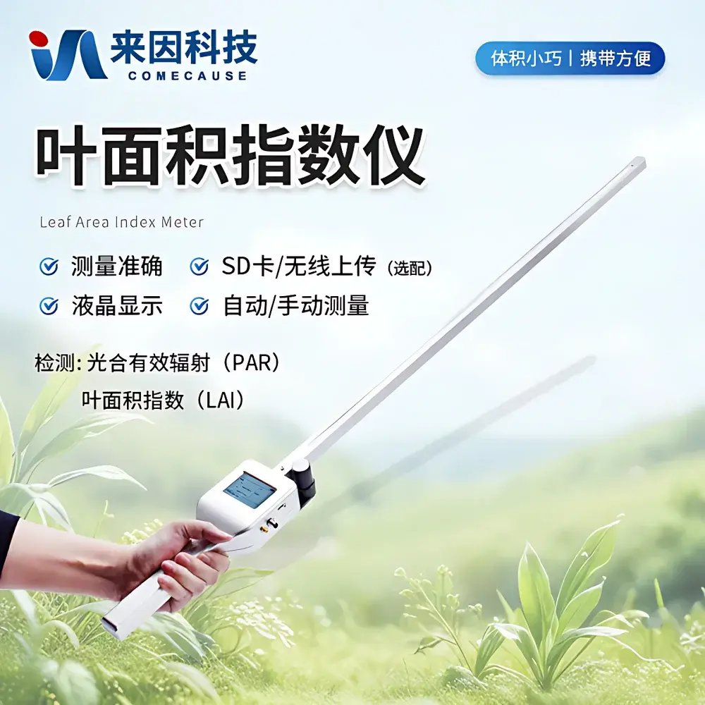
| Instrument Type | Handheld Portable |
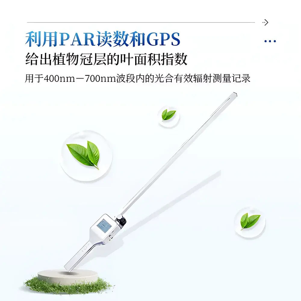
| PAR Sensor Spectral Range | 400–700 nm |
| Integrated PAR Sensor Range | 0–2700 μmol·m⁻²·s⁻¹ |
| External PAR Sensor Range | 0–4000 μmol·m⁻²·s⁻¹ |
| Resolution | 1 μmol·m⁻²·s⁻¹ (both sensors) |
| Integrated Sensor Count | 80 photodiodes |
| External Sensor Count | 1 quantum sensor |
| Probe Length | 100 cm |
| Total Unit Length | 128 cm |
| Cable Length (external sensor) | 2 m |
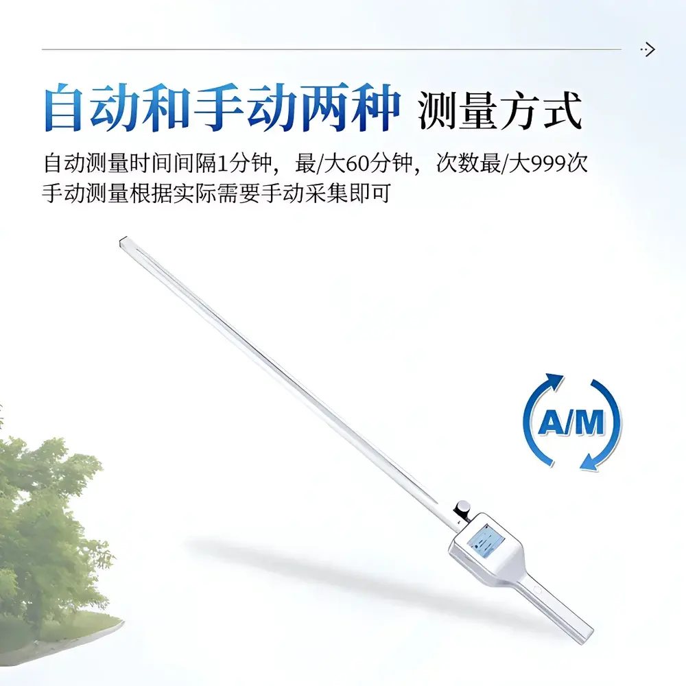
| Data Logging Interval | 1–60 min (programmable) |
| Max Log Entries | 999 (auto mode) |
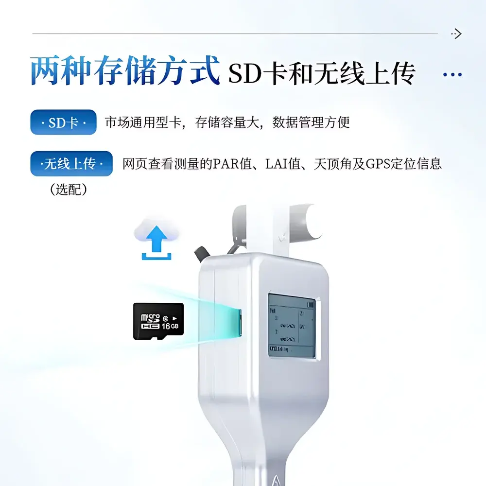
| Internal Storage | 16 GB embedded flash |
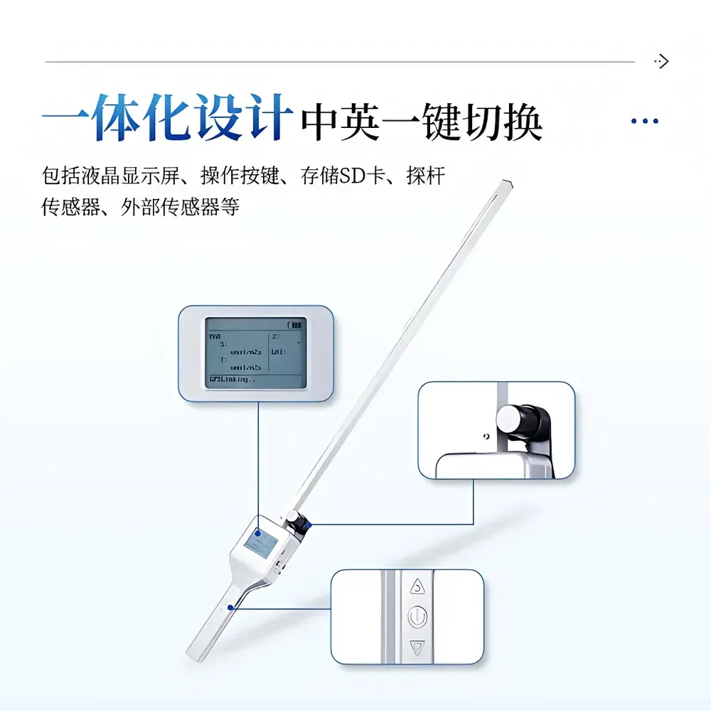
| Display | Dual-language LCD (English/Chinese), one-touch toggle |
| Power | Two 18650 Li-ion batteries (3500 mAh each) |
| Charging Interface | DC 5 V via USB-C |
| Operating Environment | 0–60 °C, 0–100% RH (non-condensing) |
| Compliance | Designed per ISO 11737-1 (light measurement principles), aligned with FAO agroecological monitoring protocols |
Overview
The COMECAUSE IN~G10 Portable Canopy Analyzer is an engineered field instrument designed for quantitative assessment of plant canopy structure and light interception dynamics in situ. It operates on the principle of diffuse transmittance-based light attenuation analysis—measuring the spatial distribution and vertical gradient of photosynthetically active radiation (PAR; 400–700 nm) beneath and above vegetation canopies. By comparing simultaneous above-canopy and below-canopy PAR fluxes, the device calculates leaf area index (LAI) using validated inversion algorithms grounded in Beer-Lambert law approximations and gap fraction modeling. Unlike optical hemispherical photography or destructive sampling methods, the IN~G10 delivers non-invasive, real-time LAI estimates with high reproducibility across heterogeneous field conditions. Its dual-sensor architecture—comprising an integrated 80-element linear PAR probe and a co-located external quantum sensor—enables synchronized, multi-point radiometric profiling without operator repositioning. The instrument is calibrated traceably to NIST-traceable quantum standards and conforms to spectral responsivity specifications outlined in ISO 17166:2022 (CIE S 025/E:2015) for PAR instrumentation.
Key Features
- Field-portable, handheld architecture with ergonomic probe design (100 cm rigid rod + 28 cm handle), total length 128 cm, weight < 1.8 kg
- High-density 80-channel integrated PAR probe with 1 μmol·m⁻²·s⁻¹ resolution and linear response across 0–2700 μmol·m⁻²·s⁻¹ range
- Dedicated external quantum sensor (0–4000 μmol·m⁻²·s⁻¹) mounted on adjustable boom for precise above-canopy reference irradiance capture
- Embedded GPS module (±2.5 m CEP, WAAS-enabled) synchronized with each PAR/LAI measurement for georeferenced data mapping
- Programmable autonomous logging: user-defined intervals from 1 to 60 minutes, up to 999 sequential records per session
- Dual storage architecture: 16 GB internal flash memory + removable SD card slot (UHS-I compatible, up to 512 GB)
- Intelligent power management: automatic sleep/wake cycle triggered by motion detection and button press; battery life ≥ 14 hours continuous operation
- Real-time display of LAI, PAR ratio (transmittance), zenith angle, GPS coordinates, timestamp, and battery status
Sample Compatibility & Compliance
The IN~G10 supports measurements across diverse vegetation types—including row crops (maize, soybean), orchards, vineyards, grasslands, and forest understories—without requiring species-specific calibration. Its 100 cm probe enables rapid transect sampling at standard heights (0.5–2.0 m above ground), while the 2 m cable allows flexible placement of the reference sensor above canopy closure. The instrument meets functional requirements for LAI validation in FAO’s CropWat and AquaCrop modeling frameworks and aligns with USDA ARS field protocol F-104 for canopy light characterization. All firmware and data output formats comply with CF conventions (Climate and Forecast Metadata Conventions v1.8) for interoperability with GIS platforms (QGIS, ArcGIS) and ecological modeling tools (R ‘raster’, Python ‘xarray’). Hardware design adheres to IEC 60529 IP54 rating for dust and water resistance during outdoor deployment.
Software & Data Management
Data export is supported via USB-C direct transfer or optional Wi-Fi module (802.11n, 2.4 GHz) enabling secure HTTP(S) upload to cloud-hosted dashboards. Raw files are stored in CSV and NetCDF-4 format, including metadata headers compliant with Darwin Core and Ecological Metadata Language (EML) schemas. The companion desktop application (Windows/macOS/Linux) provides LAI uncertainty estimation based on sensor noise propagation and angular error sensitivity analysis. Audit trails record all configuration changes, calibration events, and firmware updates—supporting GLP-aligned documentation for academic and regulatory reporting. Exported datasets include full traceability: sensor serial numbers, factory calibration dates, GPS-derived elevation, and atmospheric pressure (via onboard barometer).
Applications
- Quantifying canopy development stages in precision agriculture trials (e.g., phenotyping under drought or nutrient stress)
- Evaluating light-use efficiency (LUE) in intercropping systems and agroforestry layouts
- Validating satellite-derived LAI products (e.g., MODIS MCD15A3H, Sentinel-3 OLCI) at ground truth sites
- Parameterizing radiative transfer models (e.g., SAIL, 4SAIL) for remote sensing inversion studies
- Monitoring canopy closure dynamics in perennial crop establishment (e.g., olive, almond, tea)
- Supporting carbon sequestration assessments in restoration ecology projects through LAI–biomass allometry
FAQ
What is the theoretical basis for LAI calculation in the IN~G10?
The instrument applies the modified Beer-Lambert equation incorporating clumping correction (Ω factor) and gap fraction analysis derived from directional PAR transmittance profiles across 80 discrete points.
Does the IN~G10 require annual recalibration?
Factory calibration is valid for 24 months under normal use; users receive a NIST-traceable certificate with each unit. Field verification against a reference quantum sensor is recommended before critical campaigns.
Can LAI be calculated without GPS data?
Yes—GPS is optional metadata. LAI computation depends solely on PAR ratio and probe geometry; coordinate tagging enhances spatial analysis but is not algorithmically required.
Is the firmware upgradeable in the field?
Yes—over-the-air (OTA) updates via USB-C or Wi-Fi maintain compatibility with evolving data standards and add support for new vegetation indices upon release.
How does the device handle partial canopy cover or sparse vegetation?
The 80-channel probe resolves fine-scale heterogeneity; algorithmic smoothing and outlier rejection prevent overestimation in low-LAI regimes (< 0.5), with documented accuracy ±0.15 LAI units across 0.1–8.0 range.