DSE DIT-SHYJ-200 Integrated Water Level and Rainfall Monitoring Station
| Brand | DSE |
|---|---|
| Origin | Shenzhen, China |
| Manufacturer Type | Authorized Distributor |
| Country of Origin | China |
| Model | DIT-SHYJ-200 |
| Pricing | Available Upon Request |
| Water Level Range | Up to 10 m (configurable) |
| Water Level Accuracy | ±0.2% FS |
| Rainfall Resolution | 0.1 mm (standard), optional 0.2 mm / 0.5 mm / 1.0 mm tipping-bucket sensor |
| Power Supply | Solar panel + sealed lead-acid battery (≥30 days autonomy under continuous overcast conditions) |
| Standby Current | <100 µA |
| Data Transmission | GPRS (supports scheduled reporting, rainfall-triggered alert, water level-triggered alert) |
| Local Configuration | Wireless handheld terminal (no physical interface access required) |
| Data Storage | Internal non-volatile memory for full-year rainfall & water level records |
| Surge Protection | Integrated lightning protection on all I/O interfaces |
| Reset Capability | Hardware watchdog with automatic system reboot upon hang |
Overview
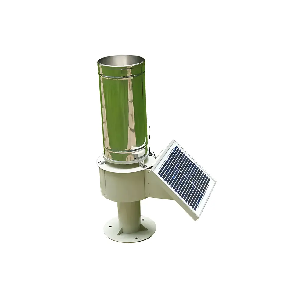
The DSE DIT-SHYJ-200 Integrated Water Level and Rainfall Monitoring Station is an autonomous, field-deployable hydrometeorological sensing platform engineered for real-time, unattended operation in remote or infrastructure-constrained environments. It employs a dual-sensor architecture: a precision pressure-based water level transducer for continuous hydrostatic head measurement, and a calibrated tipping-bucket rain gauge conforming to WMO and ISO 9634-1 specifications for precipitation quantification. Designed explicitly for flood early warning systems—including national and provincial mountain flood prevention programs—the station integrates sensing, power management, data acquisition, local storage, and wireless telemetry into a single ruggedized enclosure. Its operational principle relies on analog-to-digital conversion of sensor outputs at programmable intervals, followed by event-driven or time-scheduled transmission via GPRS to centralized SCADA or hydrological database platforms. The unit operates within the IP68-rated housing and is certified for outdoor deployment across diverse climatic zones—from subtropical monsoon regions to high-humidity inland basins.
Key Features
- Monolithic integration of pressure-type water level sensor, tipping-bucket rain gauge, solar charging controller, 12 V sealed lead-acid battery, and ARM-based data logger—eliminating external junction boxes and inter-unit cabling.
- Configurable water level measurement range up to 10 meters full scale, with factory-calibrated accuracy of ±0.2% FS; optional extended ranges available per project specification.
- Interchangeable rain gauge modules supporting resolution options of 0.1 mm, 0.2 mm, 0.5 mm, or 1.0 mm per tip—each traceable to national metrological standards.
- Solar power subsystem sized for ≥30 days of continuous operation under zero-insolation conditions, incorporating MPPT charge control and battery state-of-health monitoring.
- Ultra-low-power architecture: standby current <100 µA; supports sleep-wake cycles synchronized to rainfall accumulation thresholds or fixed time intervals.
- On-site configuration and diagnostics via 433 MHz wireless handheld terminal—no opening of enclosure or physical serial connection required.
- Hardware-level lightning protection on all analog inputs and communication ports, compliant with IEC 61000-4-5 (Surge Immunity Level 3).
- Embedded watchdog timer with automatic hard reset capability ensures recovery from software hangs without manual intervention.
Sample Compatibility & Compliance
The DIT-SHYJ-200 is validated for deployment in natural water bodies including rivers, reservoirs, irrigation canals, and detention basins. Its pressure sensor diaphragm is constructed from 316L stainless steel and compatible with freshwater, mildly saline, and sediment-laden hydraulic environments. The rain gauge funnel and bucket assembly meet WMO Guide to Hydrometeorological Practices (Chapter 7) requirements for orifice geometry and drainage dynamics. System-level compliance includes GB/T 22587–2008 (Chinese standard for automatic hydrological monitoring stations), and electromagnetic compatibility per GB/T 17626 series (equivalent to IEC 61000-4-x). While not FDA- or ISO 13485-certified (as it is not a medical device), its data integrity mechanisms—including timestamped logging, cyclic redundancy check (CRC) validation on stored records, and write-once memory allocation—support GLP-aligned long-term archival for regulatory hydrological reporting.
Software & Data Management
Data acquisition firmware supports multiple reporting protocols including SL651–2014 (China Hydrological Telemetry Standard), MQTT, and custom ASCII frame formats for integration with provincial water resource cloud platforms. Internal storage retains ≥365 days of 15-minute interval water level and cumulative rainfall values, plus event logs (e.g., low-battery alerts, sensor timeout, transmission failures). All stored records are accessible via wireless download using the DSE Handheld Configurator v3.x, which also enables remote parameter updates—including sampling interval, alarm thresholds, GPRS APN settings, and transmission mode selection (scheduled, event-triggered, or hybrid). Audit trails for configuration changes are maintained locally but not encrypted; for Part 11–compliant deployments, external middleware must handle electronic signature and change-control workflows.
Applications
- Mountain flood early warning systems (e.g., Guangxi, Yunnan, Hubei county-level deployments)
- Real-time river stage monitoring for dam safety and reservoir operation centers
- Urban flood risk mapping and stormwater infrastructure performance assessment
- Climate resilience projects requiring multi-year precipitation trend analysis
- Transboundary basin monitoring where low-maintenance, off-grid operation is mandatory
- Research-grade hydrometric data collection for hydrological model calibration (e.g., SWAT, HEC-RAS)
FAQ
What is the minimum recommended installation height for the rain gauge above ground level?
Per WMO recommendations, the orifice should be installed at 1.5 m ± 0.1 m above representative surface—avoiding turbulence from nearby vegetation or structures.
Can the water level sensor be submerged permanently in muddy or algae-prone water?
Yes; the ceramic diaphragm and stainless-steel housing resist biofouling and abrasion, though periodic visual inspection every 6 months is advised in high-sediment environments.
Does the station support NB-IoT or LTE-M as alternative communication modes?
No; only GPRS is natively supported. Cellular modem hardware is not field-upgradable.
Is firmware update possible over-the-air (OTA)?
No; firmware upgrades require physical connection via RS232 debug port and proprietary DSE Flash Utility software.
How is time synchronization handled in absence of network connectivity?
The internal RTC maintains timekeeping with ±2 seconds/month drift; GPS time sync is not integrated.