Ecodrone® Integrated Hyperspectral-LiDAR UAV Remote Sensing System
| Origin | Beijing, China |
|---|---|
| Manufacturer Type | Authorized Distributor |
| Regional Origin | Domestic (PRC) |
| Model | Ecodrone® |
| Pricing | Upon Request |
| Operating Principle | Push-broom Scanning |
| Imaging Method | Dispersive Optics |
| Deployment Mode | Airborne |
| Spectral Range | 400–1000 nm / 900–1700 nm (Hyperspectral), 905 nm (LiDAR) |
| Spectral Resolution | 5.5 nm (VNIR) |
| Ground Sampling Distance (GSD) | 3.5 cm @ 50 m AGL |
| Total Field of View (TFOV) | 38° |
| Instantaneous Field of View (IFOV) | 1024 × 640 pixels |
| Frame Rate | 330 FPS (HSI), 670 FPS (LiDAR) |
Overview
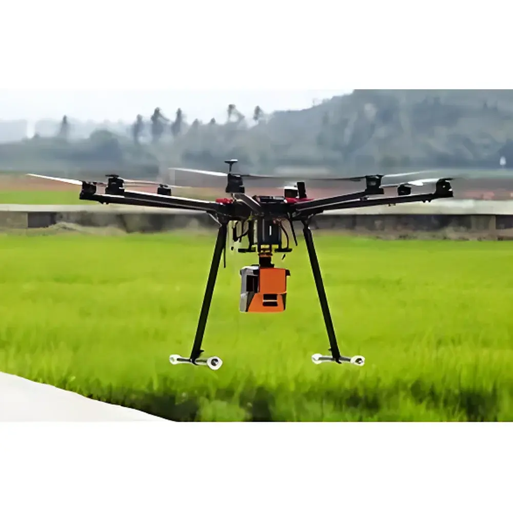
The Ecodrone® Integrated Hyperspectral-LiDAR UAV Remote Sensing System is an engineered solution for synchronized acquisition of spectral reflectance and structural topography at ecosystem scale. It combines a push-broom dispersive hyperspectral imager (VNIR and SWIR bands) with a time-of-flight LiDAR scanner on a purpose-built 1.8-kg octocopter platform. Unlike sequential or post-processed data fusion approaches, this system captures co-registered hyperspectral cubes and high-density 3D point clouds in a single flight pass—ensuring spatial, temporal, and geometric congruence between optical and structural datasets. The core measurement principle relies on passive solar reflectance spectroscopy (400–1700 nm) for biochemical characterization (e.g., chlorophyll, water content, lignin), coupled with active pulsed laser ranging (905 nm) to resolve vertical canopy architecture, ground elevation, and micro-topographic features. This dual-sensor architecture enables rigorous biophysical parameter inversion—such as leaf area index (LAI), fractional vegetation cover (FVC), canopy height model (CHM), digital terrain model (DTM), and normalized difference indices—without ground truth dependency beyond calibration validation.
Key Features
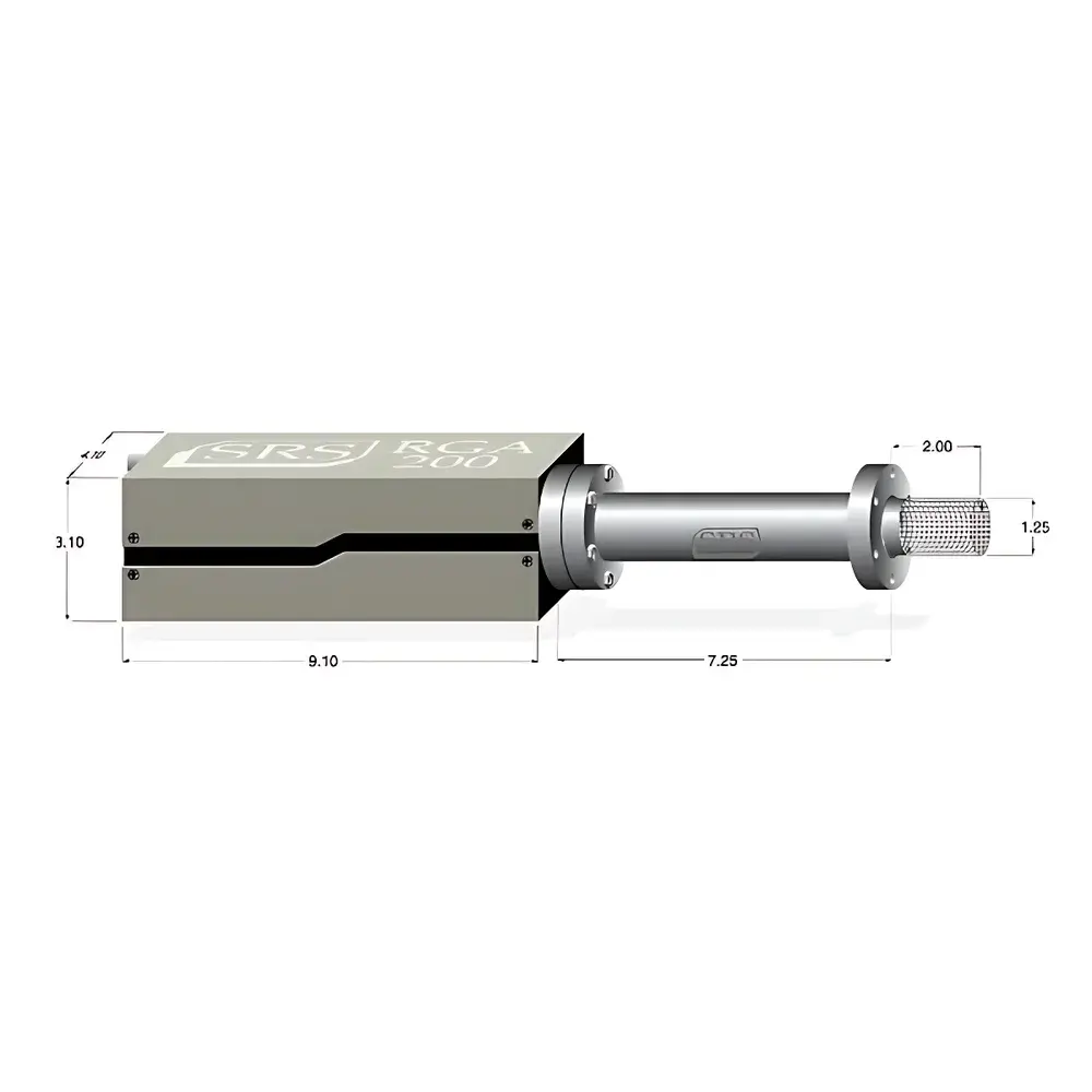
- Integrated sensor payload: Co-aligned VNIR-SWIR hyperspectral imager (400–1000 nm / 900–1700 nm) and 905 nm LiDAR with ≤2.5 cm vertical accuracy and triple-return capability
- High-fidelity spatial registration: Sub-pixel alignment between hyperspectral frames and LiDAR point clouds achieved via onboard GNSS-INS (RTK-grade positioning) and synchronized trigger logic
- Operational efficiency: >20 minutes endurance per flight; >10 ha effective coverage per sortie at 50 m AGL
- Resolution performance: 3.5 cm GSD at 50 m altitude (hyperspectral); 700 pts/m² point density at same altitude with ≥3 returns
- Real-time onboard processing: Embedded PC performs radiometric calibration, geotagging, and preliminary cloud masking during acquisition
- Robust platform design: Octocopter airframe with redundant ESCs, fail-safe telemetry, and IP43-rated payload enclosure for field-deployable operation
Sample Compatibility & Compliance
The system is designed for non-destructive, in situ observation of heterogeneous natural surfaces—including vegetated canopies, bare soil, water bodies, rock outcrops, and anthropogenic infrastructure. It complies with international remote sensing best practices for ecological monitoring, including ISO 19130-2 (Imagery Sensor Models) and ASTM E2921-22 (Standard Guide for Hyperspectral Imaging Data Collection). Data acquisition workflows support GLP-aligned metadata logging (sensor temperature, exposure time, GPS timestamp, IMU orientation) and are compatible with FAIR (Findable, Accessible, Interoperable, Reusable) data principles. While not certified under FDA 21 CFR Part 11, the raw data pipeline maintains full audit trails for scientific reproducibility and peer-reviewed publication requirements.
Software & Data Management
The proprietary Ecodrone® Processing Suite provides end-to-end workflow automation—from radiometric correction (dark current subtraction, flat-field normalization, atmospheric compensation via MODTRAN-based look-up tables) to LiDAR point cloud classification (ground/non-ground separation using progressive morphological filtering). Hyperspectral data output includes ENVI-compatible BIL files with embedded spectral libraries; LiDAR outputs conform to LAS 1.4 specification. Fusion modules generate over 90 validated vegetation indices (e.g., PRI, NDVI, MCARI, SIPI), CHM/DTM rasters, classified point clouds, and object-based segmentation masks. All processing logs, parameter settings, and version-controlled scripts are archived alongside raw data to satisfy traceability requirements for academic or regulatory reporting.
Applications
- Precision agriculture: High-throughput phenotyping of crop traits (biomass, nitrogen status, drought stress) across field-scale trials
- Forest ecology: Species discrimination, vertical stratification analysis, carbon stock estimation, and disturbance detection (e.g., insect infestation, fire scars)
- Environmental monitoring: Small-waterbody mapping (ponds, seeps, ephemeral wetlands) with <2% omission error, even under shadowed or turbid conditions
- Geoscience: Lithological mapping, mine spoil characterization, and terrain-driven habitat modeling in arid and semi-arid zones
- Cultural heritage: Non-invasive survey of buried archaeological features via micro-topographic anomalies and spectral anomalies in vegetation vigor
- Infrastructure inspection: Power line corridor clearance analysis, slope stability assessment, and change detection in linear assets
FAQ
What spectral calibration standards are supported?
Factory-calibrated using NIST-traceable tungsten-halogen and diffuse reflectance standards; field recalibration options include onboard white reference panel and vicarious calibration via pseudo-invariant features (PIFs).
Is the system compatible with third-party GIS platforms?
Yes—export formats include GeoTIFF (raster), LAS/LAZ (point cloud), Shapefile (vector), and NetCDF (multidimensional arrays), all with embedded EPSG-coded georeferencing.
Can the system operate under partial cloud cover?
It supports dynamic exposure adjustment and real-time cloud-shadow masking; however, quantitative reflectance retrieval requires clear-sky conditions or concurrent atmospheric profiling.
What level of technical support is provided for algorithm development?
Ecodrone® offers documented Python and MATLAB APIs for custom index derivation, machine learning training pipelines (e.g., Random Forest, U-Net), and integration with open-source frameworks such as scikit-learn and PDAL.
Are flight mission plans exportable for regulatory submission?
Yes—mission logs (KML, CSV) include flight path, altitude profile, sensor activation timestamps, and geofence boundaries compliant with EASA UAS operational authorizations and FAA Part 107 documentation requirements.
Related Products

")
")
