EcoTech Ecodrone® UAS-4 / DJI M350/M400-Based 10-Channel Lightweight Multispectral UAV Remote Sensing System
| Brand | EcoTech |
|---|---|
| Origin | Shaanxi, China |
| Manufacturer Type | Authorized Distributor |
| Origin Category | Domestic |
| Model | Ecodrone® |
| Pricing | Upon Request |
Overview
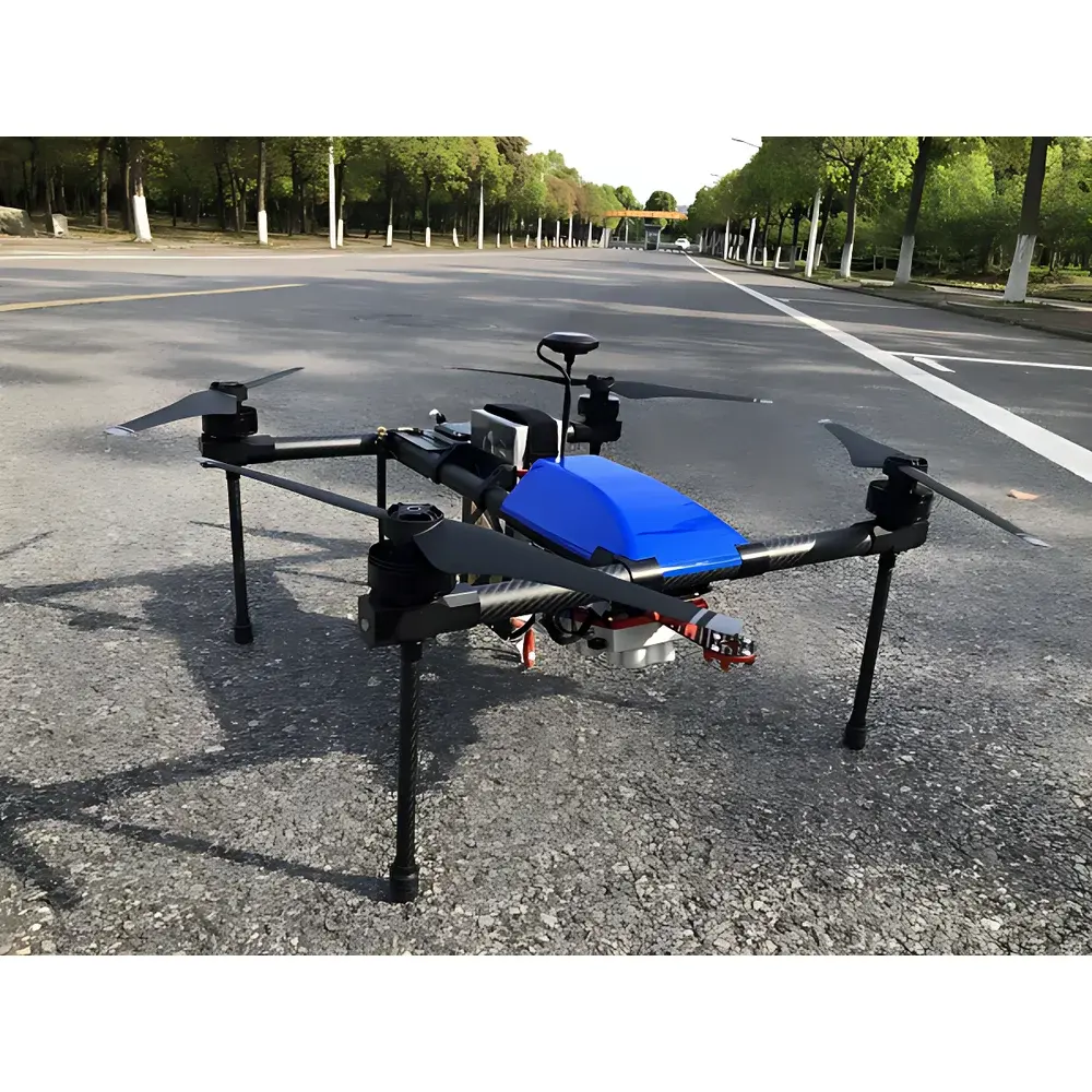
The EcoTech Ecodrone® UAS-4 / DJI M350/M400-Based 10-Channel Lightweight Multispectral UAV Remote Sensing System is a field-deployable, scientifically calibrated aerial platform engineered for high-fidelity ecological and agricultural remote sensing. Built upon either the proprietary EcoTech UAS-4 quadcopter or commercially validated DJI Matrice 350 RTK / M400 airframes, this system integrates synchronized multispectral imaging with geometric and radiometric rigor—eliminating mechanical gimbals through tilt-compensated sensor triggering and real-time DLS (Downwelling Light Sensor) + CRP (Calibration Reference Panel) dual calibration. It operates on passive optical remote sensing principles, capturing narrowband reflectance across ten discrete spectral bands (including visible, red edge, and near-infrared), enabling quantitative biophysical parameter retrieval at canopy scale. Designed for operational robustness in variable field conditions, it supports GLP-aligned data acquisition workflows and complies with ASTM E2921–22 (Standard Practice for Unmanned Aircraft Systems in Environmental Monitoring) and ISO 18620–2 (Remote Sensing — Spectral Calibration of Airborne Imaging Sensors). Its architecture prioritizes repeatability, inter-sensor synchronization, and traceable radiometry—critical for longitudinal monitoring, cross-site validation, and regulatory-grade environmental reporting.
Key Features
- Tilt-compensated, gimbal-free multispectral acquisition using synchronized hardware triggering—ensuring sub-millisecond temporal alignment across all 10 channels
- Modular triple-camera configuration supporting up to 15 spectral bands; users select any two sensors to configure a custom 10-channel solution
- Simultaneous capture of 10-channel multispectral imagery and high-resolution RGB (≥42 MP) in single flight pass
- Flight endurance up to 55 minutes (UAS-4 platform); payload-optimized weight distribution enables extended coverage per sortie
- Ground sampling distance (GSD) of 2 cm at 60 m AGL (full-color panchromatic band), with radiometric resolution ≥12-bit RAW DNG output
- Image acquisition rate of 3 frames per second in native DNG format, preserving linear response for downstream reflectance modeling
- Dual-calibration framework: integrated DLS for real-time downwelling irradiance correction + CRP-based empirical normalization—applied uniformly across all lenses to minimize inter-channel bias
- Automated safety protocols including low-battery warning, geofence-aware RTH (Return-to-Home), and IMU-based attitude stabilization under wind gusts ≤12 m/s
- Expandable modular interface supporting thermal infrared (640×512 microbolometer), ENVIS environmental sensor suite (air temperature, RH, PAR, CO₂), and LiDAR integration via CAN/RS422 bus
Sample Compatibility & Compliance
The system is validated for use over heterogeneous land surfaces—including rice paddies, forest canopies, inland lakes, coastal wetlands, and arid soils—without requiring site-specific recalibration. Radiometric accuracy is maintained across illumination gradients (e.g., morning vs. midday solar zenith angles) via DLS+CRP compensation, meeting requirements for ISO 18620–2 Level 2 radiometric consistency. Data products conform to FAO’s WaPOR (Water Productivity through Open-access Remote Sensing) metadata schema and support USDA-NRCS Soil Survey Geographic (SSURGO) spatial referencing standards. All firmware and ground control software comply with IEC 62443–3-3 cybersecurity requirements for industrial IoT devices and include audit-trail logging per FDA 21 CFR Part 11 Annex 11 for regulated environmental studies.
Software & Data Management
Acquisition and preprocessing are managed through EcoTech’s proprietary Ecodrone® Flight & Processing Suite (v5.2+), which provides mission planning with terrain-following waypoints, real-time NDVI/NDRE preview, and automated orthomosaic generation using SfM photogrammetry (Agisoft Metashape Engine API). Radiometric processing includes dark-frame subtraction, vignetting correction, and empirical line calibration against CRP reflectance targets. Export formats include GeoTIFF (with embedded RPC metadata), ENVI .hdr/.dat, and CF-compliant NetCDF-4 for interoperability with QGIS, ENVI, ArcGIS Pro, and Python-based analysis pipelines (e.g., scikit-image, rasterio, xarray). Time-series datasets support version-controlled storage via optional integration with EcoCloud™—a secure, ISO 27001-certified cloud repository offering role-based access, DICOM-like annotation tagging, and automated QC flagging for outlier pixels.
Applications
- Precision agriculture: High-throughput phenotyping for nitrogen-use efficiency (NUE), chlorophyll content mapping (SPAD proxy), red-edge slope analysis for early stress detection, and yield prediction modeling using EVI, OSAVI, and VOG indices
- Forestry & biodiversity: Canopy structure classification, LAI estimation, species-level discrimination in mixed stands, and post-disturbance regeneration tracking
- Aquatic ecosystem monitoring: Retrieval of chlorophyll-a concentration, CDOM absorption coefficients, and suspended sediment load from inland and estuarine waters using band-ratio algorithms validated against in situ Secchi disk and HPLC measurements
- Soil-landscape dynamics: Erosion risk assessment via bare-soil fraction mapping, salinity index derivation (SI = R850/R1650), and organic carbon estimation using shortwave infrared (SWIR) bands
- Urban green infrastructure: Thermal stress mapping (when integrated with thermal camera), impervious surface quantification, and vegetation health scoring for municipal sustainability reporting (e.g., UN SDG 11.7.1)
FAQ
What spectral bands are included in the standard 10-channel configuration?
The default configuration comprises 440 nm (blue), 530 nm (green), 550 nm (green edge), 570 nm (yellow), 670 nm (red), 710 nm (red edge), 760 nm (NIR1), 800 nm (NIR2), 850 nm (NIR3), and 900 nm (NIR4)—all with FWHM ≤10 nm.
Is the system compatible with third-party GIS or machine learning platforms?
Yes—orthorectified multispectral stacks are exported as georeferenced GeoTIFFs with rational polynomial coefficients (RPCs), enabling direct ingestion into Google Earth Engine, ENVI Deep Learning Module, or custom PyTorch/TensorFlow training pipelines.
How is radiometric uncertainty quantified and reported?
Each flight includes at least three CRP acquisitions per 100 ha; absolute reflectance uncertainty is ±3.2% (k=2) across all bands, validated annually against NIST-traceable standards at EcoTech’s ISO/IEC 17025-accredited calibration lab.
Can the system operate beyond visual line of sight (BVLOS)?
BVLOS operation requires country-specific regulatory approval (e.g., FAA Part 107.31, EASA STS-01); the platform meets technical prerequisites including ADS-B Out, detect-and-avoid (DAA) readiness, and redundant telemetry links—but final authorization rests with national aviation authorities.
What level of technical support and software updates does EcoTech provide?
Purchasers receive 3 years of comprehensive support including firmware/security patches, annual calibration certificate renewal, remote diagnostics, and priority access to application-specific workflow templates developed in collaboration with FAO, CGIAR, and EU Copernicus Land Monitoring Service partners.