GaiaGeo Hyperspectral Core & Soil Imaging System
| Origin | Beijing, China |
|---|---|
| Manufacturer Type | Authorized Distributor |
| Origin Category | Domestic (PRC) |
| Model | GaiaGeo |
| Pricing | Upon Request |
| Spectral Range | 970–2500 nm (400–970 nm optional) |
| Spectral Channels | 256 (continuous, at 970–2500 nm) |
| Spatial Resolution | 0.2–2 mm |
| Spatial Pixels per Line | 320 |
| Max Scan Speed | 100 lines/sec (e.g., 20 mm/sec at 0.2 mm pixel size |
| Data Format | BIL (ENVI-compatible) |
| Calibration | Factory spectral calibration |
Overview
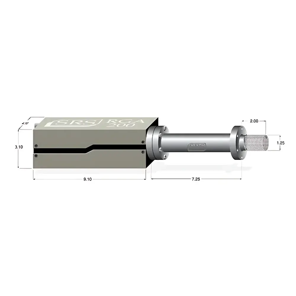
The GaiaGeo Hyperspectral Core & Soil Imaging System is a laboratory-grade, push-broom hyperspectral imager engineered for rapid, non-destructive mineralogical and geochemical characterization of drill core, sediment cores, soil sections, and geological slabs. Operating on the principle of dispersive spectroscopy coupled with linear array detection, the system captures contiguous spectral data across the short-wave infrared (SWIR) range (970–2500 nm), with optional extension into the visible-near-infrared (VNIR: 400–970 nm). Unlike conventional RGB or multispectral imaging—limited to three broad bands—the GaiaGeo acquires 256 spectrally resolved channels per spatial line, enabling identification of diagnostic absorption features associated with clay minerals (e.g., Al–OH, Mg–OH), carbonates, sulfates, iron oxides, organic matter, and hydrocarbons. Its high spectral sampling density supports quantitative spectral unmixing, endmember extraction, and spectral library matching in accordance with ASTM D7708 (Standard Practice for Spectral Analysis of Geological Materials) and ISO 11097 (Geotechnical investigation—Spectroscopic analysis of soils).
Key Features
- Optimized optical architecture for core scanning: Integrated motorized translation stage and calibrated illumination module ensure uniform irradiance and minimal geometric distortion across 1.2 m sample trays.
- Real-time radiometric correction: Each scan automatically references an onboard PTFE-based diffuse reflectance standard (certified >99% reflectance at 1000–2500 nm), eliminating drift and enabling inter-sample comparability without manual recalibration.
- Configurable spatial resolution: Adjustable working distance and lens options support 0.2 mm (high-detail mineral zoning) to 2 mm (rapid whole-core screening) pixel sizes—maintaining consistent signal-to-noise ratio (SNR > 500:1 @ 1500 nm) across all settings.
- Deterministic acquisition timing: Fixed line rate of up to 100 Hz enables sub-10-second full-tray scans (1.2 m × 320 pixels), delivering >38,000 spectra per core—compatible with high-throughput core logging workflows.
- ENVI- and Evince-ready output: Raw data exported in Band Interleaved by Line (BIL) format with embedded wavelength and georeferencing metadata, directly ingestible into spectral analysis platforms including ENVI, Python (scikit-image, spectral), and MATLAB.
Sample Compatibility & Compliance
The GaiaGeo accommodates standard geological sample formats: split core halves (up to 10 cm diameter), soil monoliths (up to 15 cm × 15 cm × 30 cm), thin sections (glass-mounted or resin-embedded), and polished slab specimens. Sample mounting requires no coating, vacuum, or conductive treatment. The system complies with IEC 61000-6-3 (EMC emission limits) and meets CE marking requirements for laboratory instrumentation. While not certified for field deployment, its mechanical stability and thermal management (passive cooling, <±0.5 °C internal drift over 2 hr) support GLP-aligned lab operation. Data provenance—including instrument ID, calibration timestamp, operator ID, and environmental sensor logs (optional ambient temperature/humidity)—is embeddable in header metadata to satisfy audit requirements under ISO/IEC 17025 and FDA 21 CFR Part 11 (when integrated with compliant LIMS).
Software & Data Management
The GaiaGeo includes proprietary acquisition software (GaiaCapture v3.x) for hardware control, real-time preview, and batch scanning scheduling. Post-acquisition processing is performed via GaiaAnalyze—a modular toolkit supporting spectral smoothing (Savitzky-Golay), atmospheric correction (empirical line method), continuum removal, spectral angle mapper (SAM), and principal component analysis (PCA). All algorithms are deterministic and scriptable via Python API. Exported spectral libraries adhere to the USGS Digital Spectral Library splib06a format, facilitating cross-platform interoperability. Audit trails record every processing step—including parameter values, user credentials, and timestamps—enabling full traceability for regulatory submissions or peer-reviewed publication.
Applications
- Core logging & lithological mapping: Automated stratigraphic unit delineation based on spectral endmembers (e.g., distinguishing illite from smectite via OH-stretch position shifts).
- Geochemical proxy detection: Quantification of Fe²⁺/Fe³⁺ ratios, total organic carbon (TOC) estimation, and sulfate abundance via partial least squares regression (PLSR) models trained on reference assays.
- Diagenetic alteration assessment: Identification of authigenic clay growth zones, oxidation fronts, and fluid migration pathways through spectral feature depth analysis.
- Soil horizon characterization: Differentiation of A-, B-, and C-horizons using combined VNIR-SWIR spectral indices (e.g., Clay Mineral Index, Iron Oxide Ratio).
- Archaeological sediment analysis: Detection of anthropogenic combustion residues (charcoal, calcined bone) and paleosol boundaries without destructive sampling.
FAQ
What spectral calibration standards are used during factory calibration?
Factory calibration employs NIST-traceable tungsten-halogen and deuterium lamps, coupled with certified diffusers, to establish absolute radiometric response across 970–2500 nm. Wavelength accuracy is verified using atomic emission lines (e.g., Ar, Ne) and validated to ±0.5 nm RMS.
Can the system be upgraded to include VNIR (400–970 nm) capability after purchase?
Yes—VNIR module integration is supported via field-installable optical path retrofit and firmware update, requiring recalibration and validation per ISO 17025 clause 5.5.2.
Is spectral data compatible with machine learning pipelines for automated lithology classification?
Absolutely—BIL files include full spectral vectors and spatial coordinates, enabling direct ingestion into TensorFlow, PyTorch, or scikit-learn workflows. Example Jupyter notebooks for CNN-based core segmentation are provided in the GaiaGeo Developer Kit.
How is measurement repeatability ensured across multiple operators or days?
Automated per-scan radiometric correction, fixed illumination geometry, and serialized instrument ID embedding in metadata ensure inter-operator and inter-day reproducibility. Typical spectral repeatability (1σ) is <0.8% reflectance units over 8-hour sessions.
Does the system meet requirements for regulatory submission (e.g., EPA, USGS, or mining permit applications)?
Data generated satisfies technical adequacy criteria outlined in EPA Method 8000D (Spectroscopic Screening) and USGS Open-File Report 2021–1028. Full compliance documentation (IQ/OQ protocols, calibration certificates, uncertainty budgets) is available upon request.
Related Products


")