HACH OTT RLS Pulse Radar Water Level Sensor
| Brand | OTT Hydromet |
|---|---|
| Origin | Imported |
| Model | OTT RLS |
| Measurement Principle | Pulsed Radar (Time-of-Flight) |
| Range | Up to 35 m |
| Accuracy | ±3 mm |
| Output Interfaces | RS-485, SDI-12, Analog (4–20 mA / 0–10 V) |
| Power Consumption | 12 mA @ 12 VDC (active measurement mode) |
| Enclosure Rating | IP67 |
| Operating Temperature | –40 °C to +70 °C |
| Mounting | Non-contact, top-down installation |
| Wave Compensation | Real-time dynamic averaging (≈16 measurements/sec) |
| Compliance | CE, RoHS, EN 61326-1 (EMC), IEC 60529 (IP67) |
Overview
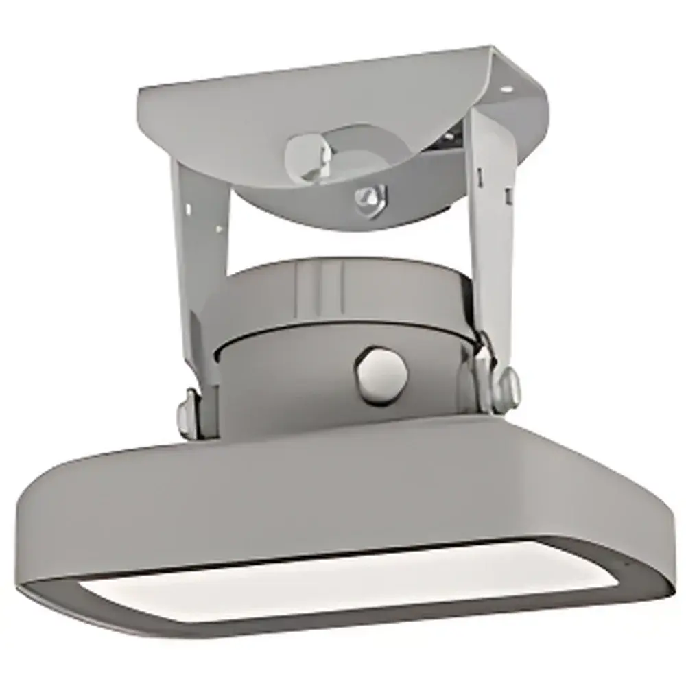
The HACH OTT RLS Pulse Radar Water Level Sensor is a high-reliability, non-contact level measurement instrument engineered for long-term deployment in challenging hydrological environments. It operates on the time-of-flight (ToF) principle using low-power pulsed radar technology—emitting short microwave pulses (24 GHz ISM band) toward the water surface and precisely measuring the round-trip propagation delay of the reflected signal. This physical principle ensures immunity to ambient temperature gradients, atmospheric humidity, water turbidity, floating debris, submerged vegetation, sediment accumulation, and chemical corrosion—factors that commonly compromise float, pressure, ultrasonic, or bubbler-based systems. The sensor’s fixed-beam antenna design minimizes side-lobe interference and enables stable operation even under partial obstruction (e.g., bridge decks, narrow culverts, or forested banks). Its compact form factor (Ø120 × 110 mm) and IP67-rated housing support rapid installation on existing infrastructure—including bridges, weirs, flumes, and remote telemetry poles—without requiring stilling wells, stilling pipes, or submerged components.
Key Features
- Pulsed radar operation with ultra-low power consumption: 12 mA typical at 12 VDC during active measurement cycles, enabling multi-year battery operation when paired with duty-cycled data loggers.
- Dynamic wave compensation algorithm: Performs ≈16 independent distance measurements per second; applies real-time statistical filtering (mean/median-based averaging) to suppress noise from wind-induced platform vibration, traffic-induced bridge oscillation, or surface wave action—yielding stable readings comparable to those obtained from stilling wells.
- Wide measurement range: Configurable up to 35 m (115 ft) with factory-calibrated accuracy of ±3 mm (±0.12 in) across the full span, traceable to NIST-traceable reference standards.
- Dual-standard digital interfaces: Native support for both SDI-12 (Version 1.3 compliant) and RS-485 (Modbus RTU protocol), allowing seamless integration with legacy and modern dataloggers (e.g., Campbell Scientific CR series, Onset HOBO, Delta-T DL2e).
- Analog output flexibility: User-selectable 4–20 mA or 0–10 V analog output with galvanic isolation, compatible with SCADA PLCs and industrial RTUs without additional signal conditioning.
- Robust environmental hardening: Aluminum alloy housing with UV-stabilized polymer radome; lightning protection integrated per IEC 61643-21 (Type 2 SPD); operational reliability verified over –40 °C to +70 °C ambient range.
Sample Compatibility & Compliance
The OTT RLS is validated for continuous monitoring of natural and engineered water bodies—including open channels, rivers, reservoirs, stormwater retention basins, irrigation canals, and tidal estuaries. It maintains metrological integrity in highly dynamic flow regimes where surface turbulence, air entrainment, or suspended solids would degrade contact-based sensors. Regulatory compliance includes CE marking under the EMC Directive 2014/30/EU and Low Voltage Directive 2014/35/EU; RoHS 2011/65/EU conformity; and mechanical robustness certified to IEC 60529 IP67. While not inherently certified for SIL or ATEX zones, its intrinsic safety profile (low energy, no moving parts, no hazardous materials) supports deployment in Class I, Division 2 hazardous locations when installed per NEC Article 501 guidelines. Data integrity meets GLP-aligned field recording requirements when used with audit-trail-capable dataloggers supporting timestamped metadata logging.
Software & Data Management
The sensor operates autonomously without embedded firmware updates or cloud dependency. Configuration is performed via ASCII command set over RS-485 or SDI-12, supporting parameters such as measurement interval (1 s to 24 h), output scaling, damping coefficient, and unit selection (m, ft, cm). Raw distance values are transmitted with millisecond-precision timestamps when synchronized to external GPS PPS signals. When integrated with HACH’s DataSuite or third-party platforms like HydroSphere, AquaAlert, or USGS NWIS, the OTT RLS supports automated QA/QC flagging—including spike detection, freeze-thaw event tagging, and signal strength monitoring (RSSI). All communication protocols adhere to ANSI/AWWA G200-21 and ISO 14001-2015 environmental data exchange conventions.
Applications
- Flood early warning systems (FEWS) in mountainous or flash-flood-prone catchments where rapid deployment and battery longevity are critical.
- Regulatory compliance monitoring for NPDES permits, WFD (EU Water Framework Directive), and EPA Clean Water Act Section 402 reporting.
- Hydropower intake level control and tailrace monitoring under high-silt-load conditions.
- Urban drainage network surveillance—especially in combined sewer overflow (CSO) structures where submersion risks render pressure transducers unreliable.
- Long-term climate observation networks (e.g., GCOS, GEOSS) requiring decade-scale sensor stability and minimal maintenance intervention.
- Coastal and estuarine applications where salinity, biofouling, and tidal range exceed the operational envelope of submerged technologies.
FAQ
What is the minimum measurable distance?
The OTT RLS has a near-field blanking distance of 0.15 m (6 in), below which reliable echo detection cannot be guaranteed due to antenna coupling effects.
Can it measure through ice?
No—microwave pulses are attenuated by solid ice layers; the sensor requires a clear line of sight to liquid water surface.
Is firmware upgrade supported in-field?
Firmware is factory-programmed and not user-upgradable; functional enhancements are delivered via hardware revision (e.g., RLS v2.1 introduces enhanced low-SNR tracking).
Does it require periodic calibration?
No scheduled recalibration is required; factory calibration remains stable over the rated service life (≥10 years) under normal environmental exposure.
How does it handle heavy rainfall or snowfall?
The radome is hydrophobic and self-draining; rain/snow accumulation on the lens causes negligible signal loss (<0.5 dB insertion loss at 24 GHz), and the pulse processing algorithm rejects transient backscatter from falling hydrometeors.


