LS-MB1200MM Oil Spill Monitoring Buoy
| Origin | Guangdong, China |
|---|---|
| Manufacturer Type | Authorized Distributor |
| Origin Category | Domestic (PRC) |
| Model | LS-MB1200MM |
| Pricing | Available Upon Request |
Overview
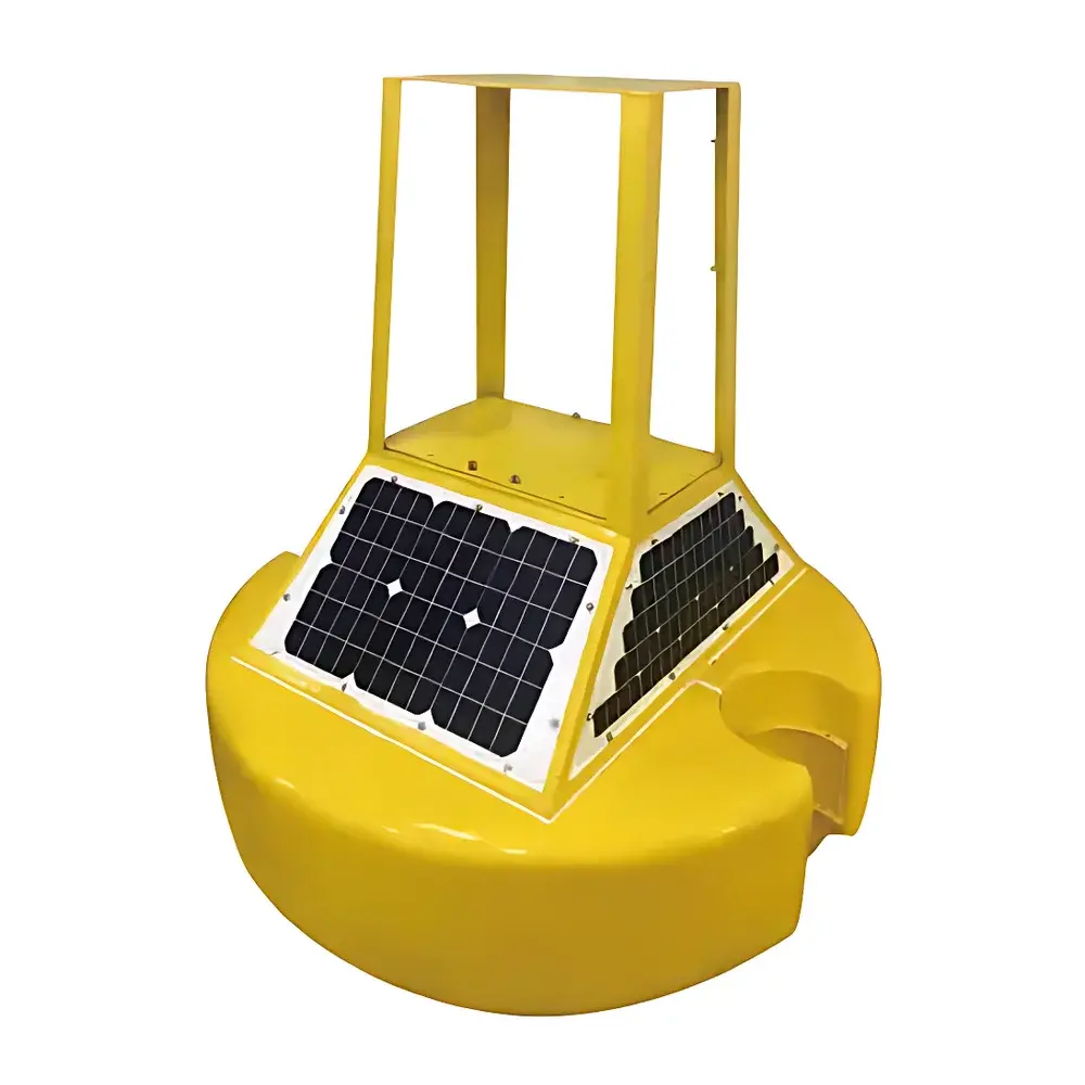
The LS-MB1200MM Oil Spill Monitoring Buoy is an integrated, autonomous marine environmental surveillance platform engineered for real-time detection and verification of hydrocarbon spills—including crude oil, diesel, gasoline, and other hazardous chemical releases—on inland waterways, coastal zones, and nearshore marine environments. Operating on the principle of multi-spectral optical imaging combined with intelligent visual anomaly detection, the buoy continuously monitors surface reflectance patterns to identify oil slicks based on characteristic sheen morphology, thickness-dependent interference colors, and spatial continuity. Unlike passive sensor-only systems, the LS-MB1200MM incorporates active onboard imaging and georeferenced event logging, enabling definitive spill confirmation rather than probabilistic inference. Its compact, low-draft design (1.2 m mast height, sub-15 kg operational mass) ensures deployment flexibility across rivers, reservoirs, estuaries, and sheltered littoral zones without requiring vessel support or permanent mooring infrastructure.
Key Features
- Multi-modal positioning: Dual-mode GNSS receiver supporting both GPS (L1 C/A) and BeiDou (BDS B1I) constellations for continuous, sub-5 m horizontal accuracy under dynamic maritime conditions.
- Onboard HD imaging system: 4 MP CMOS camera with auto-exposure control, wide-angle lens (110° FOV), and programmable capture intervals (1–30 min); images embedded with UTC timestamp, GPS coordinates, and orientation metadata.
- Robust telemetry architecture: Integrated BeiDou short-message service (SMS) module for low-bandwidth, high-reliability alarm transmission—even in areas with no cellular coverage; optional 4G LTE fallback for high-volume data transfer.
- Modular sensor interface: Standard RS-485 and analog (0–5 V / 4–20 mA) ports compliant with common water quality (e.g., turbidity, pH, DO, conductivity), meteorological (wind speed/direction, air temperature, barometric pressure), and hydrological (water level, wave height) sensors.
- Industrial-grade power management: Solar-charged lithium-iron-phosphate (LiFePO₄) battery pack (12 V / 24 Ah) with smart charge controller; supports ≥6 months autonomy under typical coastal insolation (≥3.5 kWh/m²/day).
- Marine-hardened enclosure: IP68-rated high-density polyethylene (HDPE) buoy body with UV-stabilized polymer coating; impact-resistant to >2 m/s collision energy per ISO 19901-7; operational range: −20 °C to +55 °C.
Sample Compatibility & Compliance
The LS-MB1200MM is designed for deployment in freshwater, brackish, and saline environments up to 30 ppt salinity. Its optical detection methodology does not require direct fluid sampling, eliminating cross-contamination risk and enabling long-term unattended operation. The buoy conforms to IEC 60529 (IP68), ISO 14644-1 (cleanroom-adjacent assembly protocols), and GB/T 19001–2016 (equivalent to ISO 9001). Data integrity meets GLP-aligned audit-trail requirements: all image captures, position fixes, and sensor readings are time-stamped via NTP-synchronized RTC and stored with immutable write-once metadata. While not certified for Class I Div 1 hazardous locations, it complies with CE marking directives for EMC (2014/30/EU) and RoHS 3 (2015/863/EU).
Software & Data Management
The buoy interfaces with the vendor’s cloud-based Environmental Data Hub (EDH), accessible via secure HTTPS portal or RESTful API. Raw image streams and sensor time-series are ingested, indexed by geospatial hash (Geohash-7), and tagged using configurable alert rules (e.g., “oil-slick-like pattern + GPS velocity 90 s”). EDH supports role-based access control (RBAC), automated PDF report generation (per ISO 14064-3 Annex A), and export in CSV, NetCDF, or GeoJSON formats. Audit logs record all configuration changes, firmware updates, and user actions—fully traceable for regulatory review. Optional integration with national platforms such as China’s National Ecological Environment Monitoring Platform (NEEMP) or international systems like EMODnet Physics is supported via standardized OGC SensorThings API v1.1.
Applications
- Real-time early warning for port authorities and oil terminal operators along Yangtze River, Pearl River Delta, and Bohai Bay corridors.
- Regulatory compliance monitoring for Tier II Spill Prevention Control and Countermeasure (SPCC) plans under Chinese MEP Order No. 48.
- Baseline environmental surveillance during offshore construction (e.g., wind farm pile driving) to document pre- and post-activity hydrocarbon presence.
- Integration into river basin management systems (e.g., Pearl River Basin Commission) for cross-jurisdictional pollution source attribution.
- Research-grade deployment in mesocosm studies evaluating biodegradation kinetics of weathered hydrocarbons under controlled tidal forcing.
FAQ
Does the LS-MB1200MM require calibration against reference oil films?
No—optical detection relies on relative spectral contrast and geometric signature analysis, not absolute radiometric calibration. Field validation is performed using ASTM D7723-14 standard test methods for remote sensing of oil on water.
Can the buoy operate in strong currents or wave heights exceeding 1.5 m?
Yes—its low center-of-gravity design and tethering compatibility (via optional stainless-steel mooring kit) ensure stable operation up to Sea State 4 (moderate waves, 1.25–2.5 m), per WMO Sea State Code.
Is firmware update capability available over-the-air (OTA)?
Yes—secure OTA updates are delivered via signed binary packages authenticated using ECDSA-P256; rollback protection and dual-bank flash memory prevent bricking.
What is the maximum distance between the buoy and base station for reliable BeiDou SMS transmission?
BeiDou short-message service operates via geostationary satellites; line-of-sight is not required—effective range covers all landmasses and EEZs within the Asia-Pacific BDS coverage zone (70°E–140°E, 55°N–55°S).
Related Products


