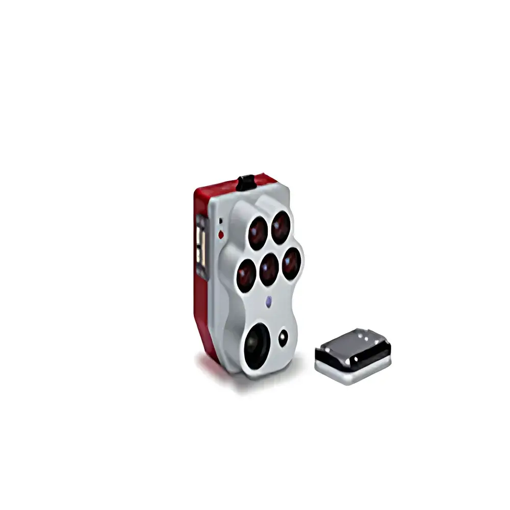
Micasense Altum-PT Multispectral Imaging System
| Brand | Micasense |
|---|---|
| Origin | USA |
| Manufacturer Status | Authorized Distributor |
| Import Status | Imported |
| Model | Altum-PT |
| Price Range | USD 13,500 – 27,000 (est. based on ¥100,000–200,000 at 7.4 CNY/USD) |
| Weight | 460 g (camera + DLS2) |
| Dimensions | 11 × 8 × 6.9 cm |
| Power Input | 7–25.2 V DC |
| RGB Sensor | 12.4 MP global shutter, pixel-aligned with multispectral bands |
| Thermal Band | LWIR, 7.5–13.5 µm |
| GSD @ 120 m AGL | 5.28 cm (multispectral), 33.5 cm (thermal), 2.49 cm (panchromatic RGB) |
| Capture Rate | 2 Hz |
| Interfaces | 3 configurable GPIO (trigger in/out, PPS in/out, frame sync) |
| FOV | 50° H × 38° V (multispectral), 46° H × 35° V (panchromatic), 48° × 39° (thermal) |
| Storage | CFexpress Type B card |
Overview
The Micasense Altum-PT is a high-integration, tri-sensor remote sensing payload engineered for precision environmental and agricultural monitoring from unmanned aerial platforms. Unlike conventional multispectral systems, the Altum-PT simultaneously captures synchronized, pixel-aligned data across three distinct spectral domains: five-band visible–near-infrared (VNIR) multispectral imagery, high-resolution panchromatic RGB, and uncooled long-wave infrared (LWIR) thermal radiometry. Its core architecture leverages a single optical bench and shared geometric reference frame to ensure sub-pixel co-registration—eliminating post-processing misalignment artifacts common in multi-camera rigs. This hardware-level synchronization enables robust vegetation index derivation (e.g., NDVI, NDRE, CIrededge), canopy temperature mapping, and high-fidelity surface reflectance modeling—all within a single pass. Designed for operational deployment across fixed-wing, VTOL, and small rotary-wing UAVs, the Altum-PT meets the stringent weight, power, and interface requirements of industrial-grade flight platforms while maintaining laboratory-grade radiometric stability.
Key Features
- Precision Pixel Alignment: All sensors share a common optical axis and mechanical housing, delivering native <1-pixel spatial registration between VNIR, panchromatic, and thermal layers—critical for pixel-wise analytics such as stomatal conductance estimation or thermal–reflectance fusion models.
- Triple-Modal Synchronization: Captures full multispectral (5 bands), panchromatic (12.4 MP global shutter), and thermal (LWIR, 7.5–13.5 µm) datasets at 2 Hz, enabling time-critical applications including irrigation scheduling during diurnal temperature cycles.
- Integrated Radiometric Calibration: Ships with factory-calibrated radiometric coefficients embedded in metadata (EXIF/XMP), supporting traceable reflectance conversion per ASTM E2593 and ISO 18587 standards when used with the included Downwelling Light Sensor 2 (DLS2).
- Industrial-Grade I/O Architecture: Three programmable GPIO lines support TTL trigger inputs, PPS time synchronization, frame-sync signaling, and external sensor triggering—facilitating integration into automated survey workflows compliant with FAA Part 107 and EASA UAS operational frameworks.
- Ruggedized Embedded Design: Compact form factor (11 × 8 × 6.9 cm), low mass (460 g with DLS2), and wide input voltage range (7–25.2 V DC) ensure compatibility with diverse UAV power buses and vibration environments per MIL-STD-810G shock/vibration profiles.
Sample Compatibility & Compliance
The Altum-PT is optimized for acquisition over vegetated surfaces—including row crops, orchards, vineyards, forest canopies, and wetland ecosystems—at altitudes ranging from 30 m to 200 m AGL. Its spectral response aligns with USDA NRCS soil moisture protocols and FAO crop water stress index (CWSI) methodologies. The system complies with FCC Part 15 Class B emissions limits and CE RED Directive 2014/53/EU for airborne radio equipment. Radiometric calibration traceability follows NIST-traceable procedures documented in the Micasense Calibration Certificate (included). Data outputs conform to GeoTIFF, TIFF, and JPEG2000 formats with embedded GDAL-compatible geotags and RPC metadata—ensuring interoperability with ESRI ArcGIS Pro, QGIS, Pix4Dmapper, and Agisoft Metashape under ISO 19115-3 metadata schema.
Software & Data Management
Data acquisition and preprocessing are supported via the Micasense RedEdge Capture mobile app (iOS/Android) and the desktop-based Micasense Atlas cloud platform. Atlas provides automated radiometric correction, orthomosaic generation, band math scripting (Python API), and export to industry-standard formats including ENVI .hdr, ERDAS Imagine .img, and Cloud Optimized GeoTIFF (COG). Raw image sequences include embedded IMU telemetry, GPS timestamps, and DLS2 irradiance measurements—enabling reproducible BRDF correction and temporal normalization. For regulated environments, Atlas supports audit trails, user role-based access control, and export logs compliant with FDA 21 CFR Part 11 requirements when deployed on validated on-premise servers.
Applications
- Agricultural precision management: Variable-rate irrigation, nitrogen use efficiency modeling, early disease detection via thermal–spectral anomaly clustering
- Ecological monitoring: Wetland hydroperiod assessment, invasive species mapping using red-edge reflectance gradients
- Forestry inventory: Canopy height modeling via panchromatic–multispectral stereo matching, fire risk index (FRI) derivation from thermal emissivity variance
- Environmental compliance: Post-remediation vegetation recovery tracking per EPA Method 1669, landfill methane plume screening via thermal contrast analysis
- Urban heat island studies: High-resolution surface temperature mapping integrated with NDVI-derived impervious surface classification
FAQ
Does the Altum-PT require external calibration targets for routine field use?
No—radiometric calibration is performed at the factory using NIST-traceable integrating sphere sources. Field validation is recommended annually or after significant mechanical impact, using the optional Micasense Reflectance Panel Kit.
Can thermal data be radiometrically calibrated to absolute temperature (°C)?
Yes—the LWIR sensor outputs calibrated radiance values (W·sr⁻¹·m⁻²) that can be converted to kinetic surface temperature using atmospheric transmittance models (e.g., MODTRAN) and emissivity assumptions (default ε = 0.97 for green vegetation).
Is the CFexpress storage compatible with standard UAV gimbal mounts?
Yes—the CFexpress Type B slot uses a standardized M.2 2230 form factor with passive cooling design, and the mechanical footprint conforms to common UAV payload mounting interfaces (e.g., DJI SkyPort, Freefly ALTA, Autel EVO II Pro).
What level of georeferencing accuracy can be achieved without RTK/PPK?
With standard GNSS (GPS + GLONASS), horizontal accuracy is typically 1–3 m CE90; integration with dual-frequency RTK/PPK receivers (e.g., Emlid Reach M2, Trimble R1) improves this to <5 cm CE90 under open-sky conditions.
Does Micasense provide SDK access for custom flight controller integration?
Yes—the Altum-PT exposes a documented UART protocol and RESTful API endpoints via Ethernet, enabling direct integration with PX4-based autopilots, ArduPilot firmware, and proprietary ground control stations.
Related Products


