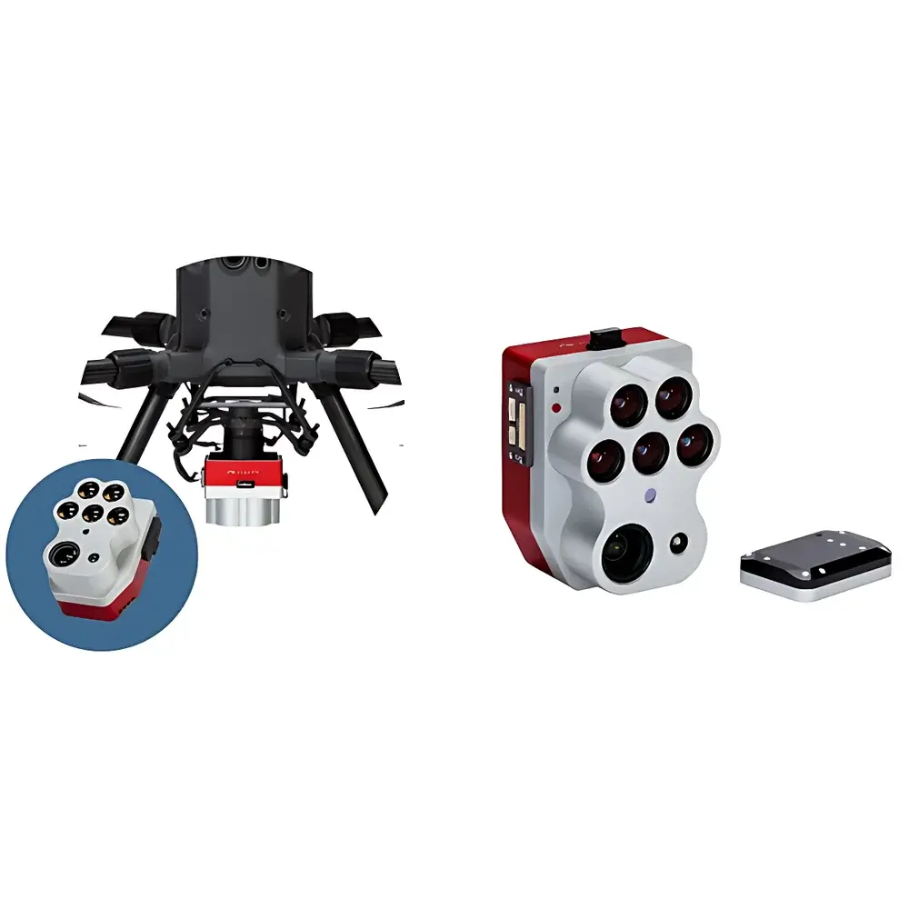
MicaSense Altum-PT Tri-Sensor High-Resolution Multispectral Camera
| Origin | USA |
|---|---|
| Manufacturer Type | Authorized Distributor |
| Origin Category | Imported |
| Model | Altum-PT |
| Pricing | Upon Request |
| Effective Pixels | 4112 × 3008 (Panchromatic) |
| Pixel Array | 2064 × 1544 (Multispectral), 320 × 256 (Thermal) |
Overview
The MicaSense Altum-PT is a tri-sensor, high-resolution multispectral imaging system engineered for precision remote sensing in agricultural research, environmental monitoring, and plant phenotyping. Unlike conventional single-sensor platforms, the Altum-PT integrates three optically and temporally synchronized imagers within a single, compact housing: a 12-megapixel panchromatic (PAN) sensor, a 320 × 256 uncooled long-wave infrared (LWIR) thermal imager based on FLIR Boson® technology, and five discrete-band multispectral sensors covering blue (475 nm ± 32 nm), green (560 nm ± 27 nm), red (668 nm ± 14 nm), red edge (717 nm ± 12 nm), and near-infrared (842 nm ± 57 nm). All three modalities capture data simultaneously at pixel-level alignment—eliminating post-acquisition co-registration errors and enabling physically consistent radiometric analysis across spectral and thermal domains. The system operates on the principle of spatially registered multi-modal radiometry: each pixel contains co-located reflectance (VIS–NIR), emissivity-derived temperature (LWIR), and high-resolution structural context (PAN), facilitating quantitative biophysical parameter retrieval such as canopy temperature differential (CTD), water stress index (WSI), normalized difference vegetation index (NDVI), and pan-sharpened vegetation indices with sub-centimeter ground sampling distance (GSD).
Key Features
- Tri-sensor synchronization: Simultaneous acquisition of panchromatic, multispectral, and thermal data with hardware-level pixel alignment—no software-based registration required.
- CFexpress Type B storage interface: Enables sustained 2 Hz capture rate at full sensor resolution, supporting high-speed UAV operations and efficient field data throughput.
- Pan-sharpening capability: Leverages the 12 MP panchromatic sensor (4112 × 3008) to enhance spatial fidelity of multispectral bands (2064 × 1544), delivering radiometrically calibrated, high-resolution vegetation indices at ≤2.5 cm GSD at 120 m AGL.
- Enhanced thermal resolution: Integrated FLIR Boson® LWIR imager (320 × 256, 7.5–13.5 µm) achieves 33.5 cm GSD at 120 m AGL—double the spatial resolution of its predecessor Altum—enabling detection of micro-scale canopy temperature gradients.
- Ruggedized embedded design: Weighing only 460 g (including DLS 2 downwelling light sensor), with IP64-rated enclosure, operating voltage range 7.0–25.2 V DC, and thermal management optimized for extended UAV flight durations.
- Flexible I/O architecture: Three configurable GPIOs (trigger input, PPS in/out, frame sync), USB 2.0 (Wi-Fi module interface), RS-232 serial port, and Gigabit Ethernet for real-time telemetry, firmware updates, and direct storage access.
Sample Compatibility & Compliance
The Altum-PT is designed for integration into unmanned aerial systems (UAS) compliant with ISO 18495-2:2020 (UAS-based remote sensing—Part 2: Sensor calibration and validation procedures) and supports traceable radiometric calibration workflows per ASTM E2912-21 (Standard Practice for Onboard Radiometric Calibration of Multispectral Imaging Sensors). Its spectral bandpasses are aligned with common vegetation index definitions (e.g., NDVI, NDRE, CIred-edge) and meet the spectral fidelity requirements for USDA ARS and EU Copernicus Land Monitoring Service validation protocols. The thermal channel adheres to FLIR’s factory calibration standards for uncooled microbolometers, with NIST-traceable blackbody references applied during production. Data output formats (GeoTIFF, TIFF + XMP metadata, Radiometric JPEG 2000) comply with OGC Best Practices for Geospatial Imagery and support FAO’s WaPOR (Water Productivity through Open-access Remote Sensing) data ingestion pipelines.
Software & Data Management
Data acquisition and preprocessing are supported via MicaSense’s proprietary RedEdge Capture mobile app and AgVault cloud platform, both compatible with Windows, macOS, and Linux environments. Raw sensor data undergoes onboard radiometric correction (dark current subtraction, vignetting compensation, temperature drift compensation) and is stored with embedded geotags, IMU pose data, and DLS 2 irradiance measurements. Post-processing leverages Pix4Dmapper, Agisoft Metashape, or open-source tools such as GDAL and R packages (raster, terra, lidR) for orthomosaic generation, band math, and time-series analytics. The system supports FDA 21 CFR Part 11-compliant audit trails when deployed in GLP/GMP-aligned agronomic trials—enabling secure user authentication, electronic signatures, and immutable metadata logging for regulatory submissions.
Applications
- Irrigation optimization: Quantifies canopy-to-air temperature differentials to detect under-irrigated zones, subsurface leaks, and emitter clogging—supporting variable-rate irrigation (VRI) prescription map generation.
- Early-stress detection: Identifies biotic (pathogen/pest infestation) and abiotic (nutrient deficiency, salinity, drought) stress up to 7–10 days before visible symptom onset using red edge–driven indices and thermal anomalies.
- High-throughput phenotyping: Enables non-destructive measurement of plant height, canopy cover, leaf area index (LAI), and chlorophyll content across large breeding populations under field conditions.
- Fruit yield estimation: Combines pan-sharpened RGB segmentation, NIR-based fruit count algorithms, and thermal maturity indicators to improve forecast accuracy beyond traditional manual sampling methods.
- Water use efficiency (WUE) modeling: Integrates transpiration estimates derived from thermal inertia analysis with evapotranspiration (ET) models (e.g., METRIC, SEBAL) for basin-scale water budgeting.
FAQ
Is the Altum-PT compatible with third-party UAV platforms beyond EcoDrone systems?
Yes—the Altum-PT features standardized mechanical mounting interfaces (M3 threaded holes) and electrical connectivity via 10/100/1000BASE-T Ethernet and UART, enabling integration with DJI Matrice, Autel EVO II Pro, or custom VTOL platforms using appropriate gimbal control firmware.
Does the system provide radiometric calibration certificates?
Each unit ships with a factory-applied radiometric calibration report referencing NIST-traceable standards; optional annual recalibration services are available through MicaSense-authorized labs.
Can thermal and multispectral data be processed independently?
Yes—raw band files are stored separately and retain native bit depth (12-bit multispectral, 14-bit thermal, 12-bit PAN); however, joint analysis is recommended to preserve physical consistency between reflectance and emissivity domains.
What is the maximum operational altitude for radiometric accuracy?
For optimal radiometric stability and GSD predictability, MicaSense recommends operation below 150 m AGL; atmospheric path radiance corrections become increasingly critical above this threshold and should be applied using MODTRAN or libRadtran simulations.
Is the CFexpress card hot-swappable during flight?
No—CFexpress cards must be inserted prior to power-up; hot insertion is not supported due to PCIe link initialization requirements and potential data corruption risk.