MicaSense Altum Tri-Sensor Multispectral, Thermal, and RGB Imaging System
| Origin | USA |
|---|---|
| Manufacturer Type | Authorized Distributor |
| Origin Category | Imported |
| Model | ALTUM |
| Pricing | Upon Request |
Overview
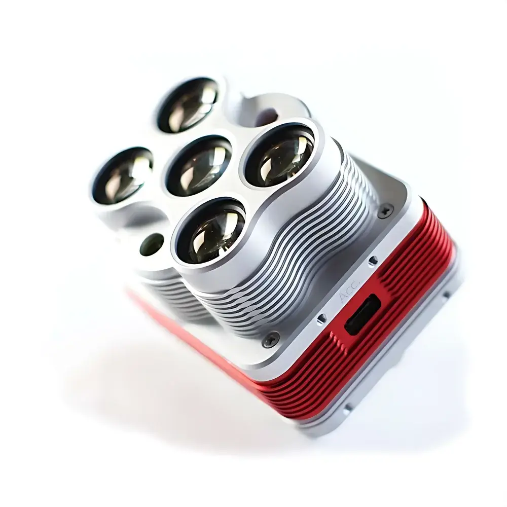
The MicaSense Altum is a tri-sensor, integrated remote sensing imaging system engineered for high-precision environmental and agricultural monitoring from unmanned aerial platforms. It combines synchronized multispectral, long-wave infrared (LWIR) thermal, and high-resolution RGB imaging within a single, compact, and robust housing—eliminating the need for sensor fusion post-flight or multi-device mounting. Based on calibrated radiometric capture principles, the Altum employs five discrete narrowband spectral sensors (Blue, Green, Red, Red Edge, and Near-Infrared) alongside a dedicated uncooled microbolometer LWIR sensor (8–14 µm), all geometrically aligned and temporally synchronized at the hardware level. This co-registered architecture ensures pixel-perfect alignment between spectral reflectance and surface temperature data—critical for quantitative plant phenotyping, evapotranspiration modeling, and stress detection in precision agriculture and ecological telemetry applications. Designed for operation under variable field conditions, the Altum features no moving parts, an IP64-rated enclosure, and wide-input voltage tolerance (4.9–25.2 VDC), enabling direct integration with most commercial UAV power systems.
Key Features
- Single-pass, hardware-synchronized acquisition of multispectral (5 bands), thermal (LWIR), and RGB data—enabling true co-registration without software interpolation or georeferencing drift.
- Radiometric calibration traceable to NIST standards via integrated DLS 2 (Downwelling Light Sensor), which concurrently records incident irradiance, GPS position, and orientation—supporting reflectance normalization compliant with ASTM E2763 and ISO 18434-1 protocols.
- High spatial fidelity: 3.2 MP per visible/NIR band (2064 × 1544), 160 × 120 pixels for thermal imagery; Ground Sampling Distance (GSD) of 5.2 cm/pixel (multispectral) and 81 cm/pixel (thermal) at 120 m AGL.
- Open-data architecture: Outputs 16-bit radiometric TIFF files with embedded metadata (EXIF, XMP), including sensor model, exposure time, gain, GPS coordinates, IMU attitude, and DLS irradiance values—facilitating reproducible processing in ENVI, QGIS, Agisoft Metashape, or custom Python-based pipelines.
- Field-deployable interface suite: USB 3.0 host port (128 GB internal storage), GPIO trigger support, PPS synchronization input, and standardized M3 mounting points compatible with DJI Matrice, Autel EVO, and custom airframes.
- Low-power, high-reliability design: 406.5 g total mass (including DLS 2), operating power draw of 5.5 W (standby), 7 W (typical), and ≤10 W (peak); rated for continuous operation across −10 °C to +50 °C ambient conditions.
Sample Compatibility & Compliance
The Altum is optimized for vegetative surface analysis—including crops (e.g., vineyards, orchards, row crops), forest canopies, wetlands, and riparian zones—where concurrent measurement of spectral reflectance and surface temperature informs biophysical parameter estimation (e.g., NDVI, NDRE, Crop Water Stress Index, Canopy Temperature Differential). Its spectral response aligns with USDA ARS and ESA Sentinel-2 bandpass definitions for cross-platform validation. The system supports GLP-aligned data acquisition workflows: raw TIFF outputs retain unprocessed sensor values, enabling audit-ready traceability. While not FDA-certified (as it is not a medical device), its radiometric stability and metadata-rich output meet foundational requirements for ISO/IEC 17025-compliant environmental laboratories conducting remote sensing validation studies.
Software & Data Management
Altum data is processed using MicaSense’s open-source Python library altum-python and the proprietary Atlas Platform, which provides cloud-based orthomosaic generation, reflectance calibration, thermal mosaic stitching, and time-series analytics. All raw data is stored in lossless 16-bit TIFF format with embedded EXIF tags containing GPS timestamps, IMU quaternions, DLS irradiance logs, and per-band exposure metadata—ensuring full reproducibility. Integration with third-party platforms (e.g., Pix4Dmapper, DroneDeploy, and custom GIS pipelines) is supported via documented REST API and GDAL-compatible georeferencing. The system complies with FAIR data principles (Findable, Accessible, Interoperable, Reusable) and supports automated ingestion into enterprise data lakes via SFTP or AWS S3 sync.
Applications
- Precision irrigation management: Detection of subsurface water leakage and localized soil moisture deficits through thermal anomaly mapping combined with red-edge chlorophyll absorption indices.
- Plant phenotyping: High-throughput quantification of canopy structure, biomass accumulation, and nitrogen status using normalized difference vegetation indices derived from co-registered multispectral bands.
- Vineyard health assessment: Early identification of Pierce’s disease and fungal infection via thermal heterogeneity patterns coupled with NIR reflectance depression.
- Ecological habitat mapping: Discrimination of invasive species and native vegetation communities using spectral-temporal signatures across seasonal growth stages.
- Post-fire recovery monitoring: Assessment of burn severity and regrowth kinetics via combined shortwave reflectance and surface temperature dynamics.
FAQ
Does the Altum require external calibration targets during flight?
No—DLS 2 provides real-time downwelling irradiance compensation, enabling reflectance calibration without manual panel captures. However, optional calibration panels are included for ground-truth verification and validation against reference spectroradiometers.
Can thermal and multispectral data be georeferenced independently?
Yes—both datasets share identical GPS/IMU metadata and are captured with sub-millisecond temporal alignment, allowing independent or fused georegistration depending on processing objectives.
Is firmware update supported over-the-air?
Firmware updates are performed via USB connection using MicaSense’s official updater tool; OTA capability is not implemented due to aviation safety and data integrity requirements.
What UAV platforms are officially validated for Altum integration?
The Altum is validated for DJI Matrice 200/300 series, Autel EVO II Pro RTK, and custom VTOL platforms with stable 10 Hz IMU output and PPS timing support.
How is radiometric accuracy maintained across varying ambient temperatures?
The LWIR sensor includes on-board non-uniformity correction (NUC) and shutterless auto-calibration routines triggered every 30 seconds during operation, ensuring thermal stability per ISO 18434-1 Annex B guidelines.
Related Products


