MicaSense RedEdge-P Multispectral Camera
| Origin | USA |
|---|---|
| Manufacturer Type | Authorized Distributor |
| Import Status | Imported |
| Model | RedEdge-P |
| Pricing | Upon Request |
| Effective Resolution | 2464 × 2056 (per band) |
| Pixel Size | 3.45 µm |
| Panchromatic Resolution | 1456 × 1088 (RGB full-color channel) |
Overview
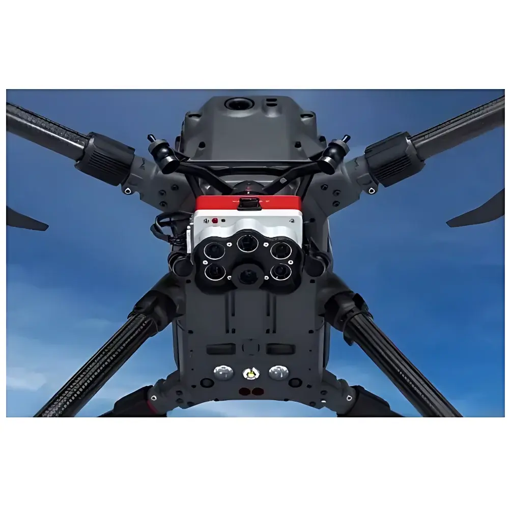
The MicaSense RedEdge-P Multispectral Camera is a field-deployable, research-grade imaging system engineered for precision agriculture, ecological monitoring, and environmental remote sensing applications. Built upon a calibrated, synchronized five-band multispectral architecture, it leverages discrete narrowband interference filters (centered at 475 nm, 560 nm, 668 nm, 717 nm, and 840 nm) paired with high-quantum-efficiency CMOS sensors to capture spectrally resolved radiance data under variable illumination conditions. Unlike broadband RGB or uncalibrated multispectral systems, the RedEdge-P implements a physics-based radiometric calibration workflow anchored to NIST-traceable standards—ensuring consistency across time, platform, and operator. Its integrated DLS 2 (Downwelling Light Sensor 2) measures incident solar irradiance and solar zenith angle in real time, enabling per-frame normalization of top-of-canopy reflectance—a critical requirement for longitudinal vegetation index computation and cross-site data harmonization. The addition of a dedicated 20 MP panchromatic RGB sensor enables simultaneous acquisition of high-fidelity true-color imagery alongside co-registered multispectral bands, supporting pixel-level fusion, visual interpretation, and rapid field validation.
Key Features
- Simultaneous capture of five discrete spectral bands + high-resolution RGB (20 MP) in a single exposure cycle
- DLS 2 integrated irradiance and solar geometry sensor for real-time radiometric correction
- Factory-calibrated using NIST-traceable reference panels; includes compact, portable calibration target (MicaSense Cal Panel v3)
- CFexpress Type B card support enabling ≥2 Hz capture rate at full resolution and bit depth
- Ground sampling distance (GSD) of 2 cm at 60 m AGL—double the spatial resolution of RedEdge-MX
- IP4X-rated enclosure for dust resistance and splash protection during field deployment
- Modular mechanical interface compatible with industry-standard gimbal mounts (e.g., DJI Ronin-MX, Gremsy T3, custom UAV integration)
Sample Compatibility & Compliance
The RedEdge-P operates as a passive optical sensor and does not require sample preparation. It is designed for aerial deployment on fixed-wing and multirotor UAVs, including but not limited to platforms such as EcoDrone UAS-4 Pro, UAS-8, and third-party airframes equipped with stabilized gimbals. All spectral bands comply with ISO 17123-9 (optoelectronic tachometers and radiometers), and raw digital numbers (DN) are convertible to physically meaningful units (W·sr⁻¹·m⁻²·nm⁻¹) via embedded calibration coefficients stored in EXIF metadata. Radiometric accuracy meets ASTM E2767-20 specifications for multispectral imaging systems used in agricultural remote sensing. Data workflows support FDA 21 CFR Part 11–compliant audit trails when integrated with MicaSense’s AgVault or third-party platforms configured for electronic record integrity.
Software & Data Management
Data acquisition is managed through the MicaSense Capture mobile application (iOS/Android) or via MAVLink-compatible flight controllers (e.g., Pixhawk). Raw TIFF sequences are processed using MicaSense Atlas cloud platform or local desktop software (Agisoft Metashape, Pix4Dmapper, QGIS with GDAL plugins). Calibration coefficients, DLS 2 telemetry, and GPS-IMU metadata are embedded in each image file, enabling automated radiometric correction and orthomosaic generation. Export formats include GeoTIFF (with reflectance-scaled bands), ENVI .hdr, and CSV-index tables for NDVI, NDRE, SAVI, and other vegetation indices. All processing pipelines adhere to GLP-aligned documentation standards—including version-controlled processing logs, input/output hash verification, and user attribution—facilitating reproducibility in regulated research environments.
Applications
- Crop phenotyping and stress detection (nutrient deficiency, water stress, disease onset)
- Time-series monitoring of canopy development, biomass accumulation, and harvest readiness
- Soil erosion mapping and land cover classification in watershed management
- Forest health assessment, species differentiation, and post-fire regeneration tracking
- Wildlife habitat characterization and fragmentation analysis using spectral heterogeneity metrics
- Regulatory compliance reporting for USDA NRCS conservation programs and EU CAP monitoring frameworks
FAQ
Is the RedEdge-P compatible with non-MicaSense drones?
Yes—it features standard Mavlink and PWM trigger interfaces, and its mechanical footprint conforms to common gimbal mounting patterns. Integration with DJI Matrice, Autel EVO II, or custom VTOL platforms requires only firmware configuration and physical stabilization.
What spectral bands does the RedEdge-P measure?
Blue (475 nm ± 15 nm), Green (560 nm ± 15 nm), Red (668 nm ± 15 nm), Red Edge (717 nm ± 15 nm), and Near-Infrared (840 nm ± 30 nm), all acquired simultaneously with sub-pixel registration accuracy.
Does the camera support radiometric calibration in-flight?
No—radiometric calibration is performed pre-deployment using the included Cal Panel v3 under uniform illumination. DLS 2 enables scene-referenced normalization, but absolute calibration remains panel-based and traceable to factory certification.
Can I process RedEdge-P data offline without cloud services?
Yes. All raw data and calibration parameters are embedded locally. Open-source tools (e.g., Python with rasterio, scikit-image) and commercial photogrammetry software support fully offline processing with no dependency on Atlas or internet connectivity.
What is the warranty and service coverage for international users?
MicaSense provides a two-year limited hardware warranty, extendable to three years with annual support contracts. Technical documentation, firmware updates, and calibration certificate archives are accessible globally via the MicaSense Support Portal without regional restrictions.


