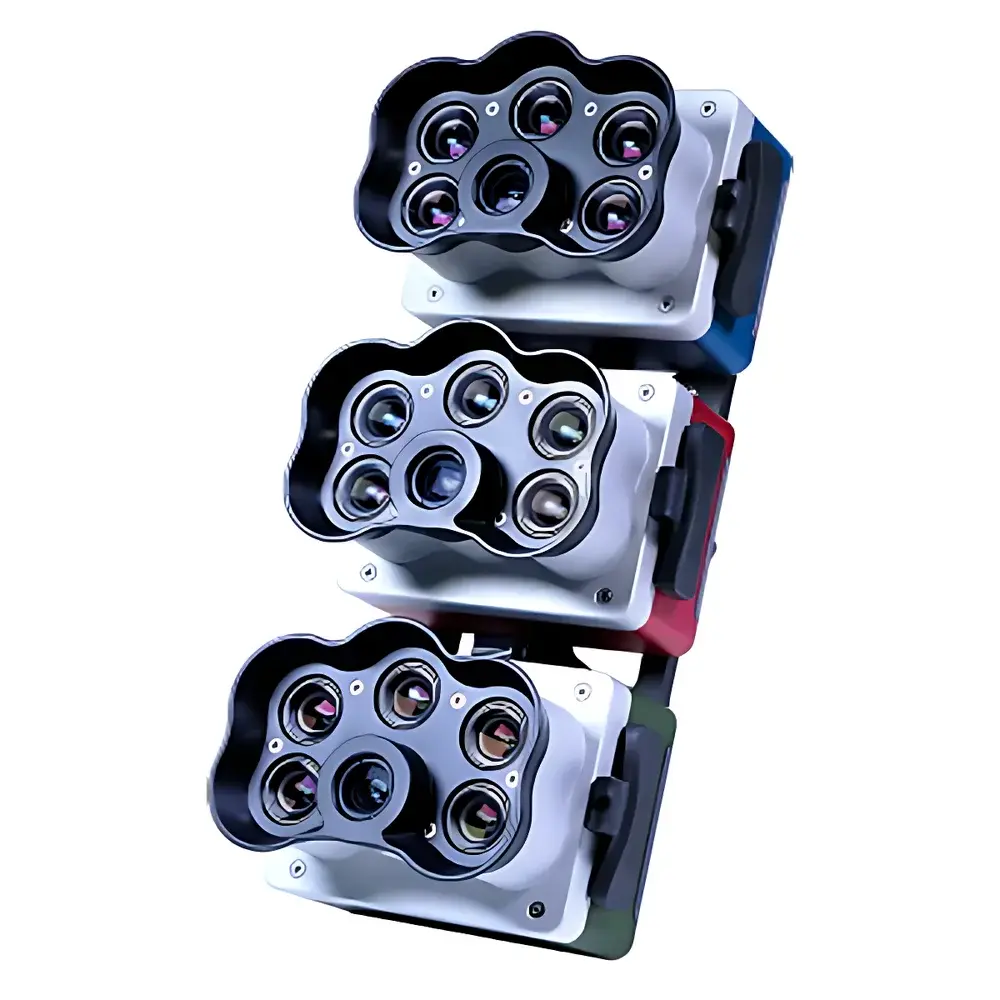
MicaSense RedEdge-P Triple Multispectral Imaging System
| Brand | MicaSense |
|---|---|
| Origin | USA |
| Model | RedEdge-P Triple |
| Weight | 1080 g (including mounting hardware, DLS2, and cables) |
| Dimensions | 21.9 cm × 11.4 cm × 9 cm |
| RGB Output Resolution | 5.1 MP (global shutter, co-registered with all spectral bands) |
| Multispectral Sensor Resolution | 1456 × 1088 (1.6 MP per band) |
| Panchromatic Resolution | 2464 × 2056 (5.1 MP) |
| GSD at 120 m | 7.7 cm/pixel (multispectral), 3.98 cm/pixel (panchromatic) |
| FOV | 50° H × 38° V (multispectral), 44° H × 38° V (panchromatic) |
| Capture Rate | Up to 3 raw DNG images/sec |
| Spectral Bands | 15 total (comprising narrowband blue, green, red, red-edge ×2–4, NIR ×2, plus panchromatic) |
| Radiometric Calibration | Dual-source (integrated DLS2 + CRP2 reflectance panel) |
| Operating Temperature | 0–40 °C (no airflow), 0–50 °C (airflow >0.5 m/s) |
| IP Rating | IP4X |
| Power Input | 7.0–25.2 V DC |
| Power Consumption | 11 W (standby), 14 W (average), 20 W (peak) |
| Interface | Three configurable GPIOs, USB 2.0 (Wi-Fi), serial, 10/100/1000 Ethernet |
| Storage | CFexpress Type B card |
Overview
The MicaSense RedEdge-P Triple Multispectral Imaging System is a modular, high-fidelity aerial imaging platform engineered for quantitative plant phenotyping and ecological monitoring. It operates on the principle of synchronized multispectral capture across 15 discrete, narrowband spectral channels—spanning visible, red-edge, and near-infrared regions—enabling precise biophysical parameter retrieval through radiometrically calibrated reflectance measurements. Unlike broadband RGB or conventional NDVI-only sensors, the RedEdge-P Triple leverages three physically separate imagers (RedEdge-P, RedEdge-P blue, and RedEdge-P green), each equipped with dedicated optical filters and global-shutter CMOS sensors. This architecture eliminates temporal misregistration and ensures pixel-level co-alignment across all bands, critical for time-series analysis, machine learning model training, and validation against ground-truth spectroscopy. Designed for integration with professional UAV platforms—including DJI Matrice and Inspire series—the system delivers sub-5 cm ground sampling distance (GSD) at operational altitudes up to 120 m, bridging the resolution gap between satellite remote sensing (e.g., Sentinel-2, Landsat) and ground-based proximal sensing.
Key Features
- Modular triple-sensor configuration supporting up to 15 narrowband spectral channels (FWHM ≤ 28 nm), including four distinct red-edge bands for enhanced chlorophyll, carotenoid, and anthocyanin sensitivity.
- Global sharpening algorithm fusing panchromatic (5.1 MP) and multispectral data to achieve 2 cm effective spatial resolution at 120 m altitude—exceeding standard satellite GSD by over two orders of magnitude.
- Dual radiometric calibration architecture: integrated Downwelling Light Sensor 2 (DLS2) with onboard GPS and inertial measurement, combined with optional CRP2 calibrated reflectance panel for field-based absolute reflectance normalization.
- Real-time geotagging and synchronized triggering: each captured DNG frame embeds precise GPS coordinates, IMU orientation, and UTC timestamps—enabling seamless orthomosaic generation and structure-from-motion (SfM) processing in Pix4Dmapper, Agisoft Metashape, or open-source workflows.
- Configurable GPIO interface supporting RTK GNSS input, PPS synchronization, external trigger signals, and frame-accurate timing control for coordinated multi-sensor flights.
- Onboard metadata logging compliant with EXIF 2.3 and XMP standards, including radiometric gain settings, exposure values, and sensor temperature—essential for GLP/GMP traceability and FDA 21 CFR Part 11–aligned audit trails.
Sample Compatibility & Compliance
The RedEdge-P Triple is validated for use across diverse vegetative systems—from greenhouse seedlings and nursery stock to mature orchards, row crops, wetlands, and coastal habitats. Its spectral response aligns with ASTM E2593-21 (Standard Practice for Spectral Reflectance Measurements of Vegetation) and ISO 19871:2020 (Remote sensing—Terrestrial vegetation—Spectral characterization). The system supports standardized vegetation indices required under USDA-NRCS protocols (e.g., NDVI, NDRE, OSAVI, PSRI, DSF) and pigment-specific metrics (PRI, ARI, CRI) referenced in USP analytical instrument qualification guidelines. All firmware and calibration files are digitally signed and version-controlled, facilitating compliance with ISO/IEC 17025:2017 clause 6.4.10 (software validation) and EU Annex 11 (Computerized Systems) requirements for regulated environmental monitoring.
Software & Data Management
Raw DNG files are processed using MicaSense’s proprietary Atlas cloud platform or locally via the open-source Python library msi, which implements radiometric correction, band registration, and index computation following the methods described in the peer-reviewed literature (e.g., *Remote Sensing of Environment*, Vol. 231, 2019). Atlas provides automated batch processing, change detection analytics, and export-ready GeoTIFFs with embedded projection metadata (EPSG:4326 or UTM). All outputs retain full bit-depth fidelity (16-bit) and support band math operations for custom index development. Data provenance—including sensor ID, calibration date, DLS2 irradiance logs, and CRP2 reference spectra—is preserved in sidecar JSON files, enabling reproducible scientific reporting and third-party verification.
Applications
- Crop Health & Stress Monitoring: Quantification of chlorophyll-a/b ratios, nitrogen status, and early water deficit stress via red-edge inflection point (REIP) analysis and time-series NDVI derivatives.
- Pigment Phenotyping: Discrimination of carotenoid-to-chlorophyll ratios (via PRI) and anthocyanin accumulation (via ARI) for fruit ripening assessment, flavor optimization, and post-harvest quality prediction.
- Weed & Species Mapping: Supervised classification (e.g., Random Forest, U-Net) trained on 15-band reflectance stacks to distinguish monocot/dicot weeds, invasive species, and crop varieties at sub-field scale.
- Ecosystem Function Assessment: Estimation of fractional vegetation cover, leaf area index (LAI), and canopy water content in riparian zones, peatlands, and mangrove forests using coupled spectral–structural modeling.
- Coastal Habitat Mapping: Detection of macroalgae blooms, seagrass meadow extent, and intertidal sediment composition via hyperspectral-like band combinations within the red-edge/NIR domain.
FAQ
Does the RedEdge-P Triple require factory recalibration after field deployment?
No—radiometric stability is maintained through DLS2 real-time irradiance compensation and optional CRP2 panel-based normalization. Annual verification against NIST-traceable standards is recommended for GLP-compliant applications.
Can the system be operated without RTK positioning?
Yes; standard GNSS provides ≤3 m horizontal accuracy. RTK integration improves geolocation precision to ≤2 cm RMS, required for sub-plot level phenotyping and longitudinal plot alignment.
Is raw DNG data compatible with ENVI, QGIS, or Google Earth Engine?
Yes—all outputs conform to GDAL-supported GeoTIFF and Cloud Optimized GeoTIFF (COG) formats. Band-specific metadata is accessible via GDAL’s GetMetadata() method for index automation.
What UAV platforms are officially supported?
DJI Matrice 300 RTK, M350 RTK, and Inspire 2 (with Zenmuse X5S mount); compatibility with Autel EVO II Pro and Freefly Alta X is verified via third-party integrators.
How is spectral crosstalk minimized across the 15 bands?
Each imager uses interference-filter-coated lenses with <0.5% out-of-band transmission, and spectral response functions are characterized pre-shipment using NIST-calibrated integrating sphere measurements.


