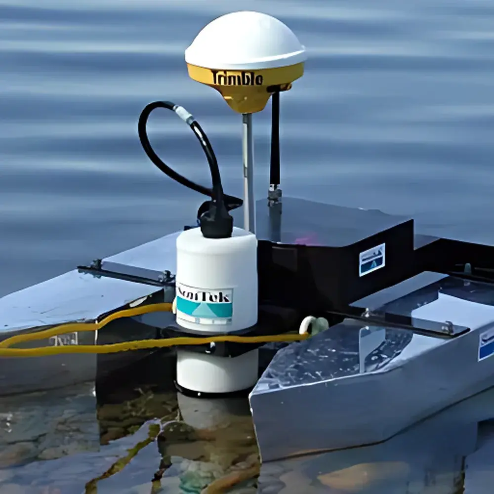
RiverCAT Acoustic Doppler Current Profiler Integrated System by SonTek/YSI
| Brand | SonTek |
|---|---|
| Origin | USA |
| Manufacturer Type | Authorized Distributor |
| Origin Category | Imported |
| Pricing | Upon Request |
| Frequency Options | 3000 kHz, 1500 kHz, 1000 kHz, 500 kHz |
| Max Depth Range | 6 m (3000 kHz), 25 m (1500 kHz), 40 m (1000 kHz), 100 m (500 kHz) |
| Min Depth Range | 0.3 m (3000 kHz), 0.5 m (1500 kHz), 1.3 m (1000 kHz), 2.0 m (500 kHz) |
| ADP Diameter | 10 cm |
| Communication | Bidirectional Radio Modem |
| Navigation & Orientation | Integrated Compass and Tilt Sensors |
| Positioning Interface | DGPS-ready (optional integrated DGPS) |
| Software Platform | RiverSurveyor v5.x (including Real-Time Flow Processing, QA/QC Flagging, and Export to CSV/Excel/HEC-RAS) |
Overview
The RiverCAT Acoustic Doppler Current Profiler (ADCP) Integrated System by SonTek/YSI is a field-deployable, vessel-mounted hydrodynamic measurement platform engineered for high-accuracy, real-time river discharge quantification across variable hydraulic conditions. Based on the principles of pulsed coherent acoustic Doppler velocimetry, the system transmits high-frequency sound pulses into the water column and analyzes frequency shifts in backscattered signals from suspended sediment or planktonic particles to compute three-dimensional velocity profiles with centimeter-scale vertical resolution. The RiverCAT integrates a lightweight aluminum catamaran hull, a compact 10-cm-diameter ADP transducer, an onboard electronics enclosure housing power management, orientation sensing (compass and dual-axis tilt), and bidirectional radio telemetry, along with factory-calibrated firmware and pre-installed RiverSurveyor software. Designed for compliance with USGS Water Resources Mission Area protocols and ISO 748:2022 (Measurement of liquid flow in open channels — Velocity-area methods), the system supports both mobile transect-based discharge surveys and stationary monitoring configurations.
Key Features
- Modular ADP architecture: Supports interchangeable transducers at 3000 kHz, 1500 kHz, 1000 kHz, and 500 kHz—each optimized for specific depth–velocity regimes while maintaining consistent beam geometry and signal processing algorithms.
- Adaptive operational modes: Automatic switching between shallow-water mode (enabling minimum detectable depth of 0.3 m at 3000 kHz) and standard profiling mode based on real-time bottom-track lock and echo amplitude feedback.
- Integrated inertial navigation: Onboard compass and tilt sensors compensate for vessel pitch, roll, and heading drift during dynamic transit, ensuring velocity vector accuracy within ±0.5° heading error and <±0.2° tilt uncertainty.
- Ruggedized marine-grade enclosure: IP67-rated electronics box with sealed battery compartment (12 V DC, 24 Ah LiFePO₄, >12 hr continuous operation), DGPS interface (NMEA 0183 compliant), and RS-232/USB connectivity for external GNSS receivers.
- Radio telemetry link: 900 MHz FHSS (Frequency-Hopping Spread Spectrum) modem enables secure, line-of-sight data transmission up to 2 km, supporting remote command execution, live velocity profile streaming, and over-the-air firmware updates.
Sample Compatibility & Compliance
The RiverCAT is validated for use in natural rivers, canals, reservoir outflows, and tidal estuaries with suspended sediment concentrations ≥20 mg/L—sufficient for reliable acoustic backscatter under typical low-to-moderate turbidity conditions. It complies with ASTM D5383–22 (Standard Practice for Field Calibration of Acoustic Doppler Current Meters), USGS Techniques and Methods Book 3, Chapter A22, and supports audit-ready data logging per GLP requirements via embedded time-stamped metadata (UTC GPS time, vessel position, battery voltage, temperature, and diagnostic flags). Optional integrated DGPS meets IALA Recommendation E-110 (Differential GNSS for Hydrographic Surveying) and enables sub-meter horizontal positioning accuracy when paired with WAAS or local RTK base stations.
Software & Data Management
RiverSurveyor v5.5+ provides a deterministic, traceable workflow—from raw ensemble acquisition and bottom detection to discharge computation using the mid-section method or index-velocity calibration. All processing steps are logged with immutable timestamps and user-defined project tags. The software supports FDA 21 CFR Part 11–compliant electronic signatures (via optional PKI module), automated QA/QC flagging (e.g., SNR <15 dB, correlation <50%, invalid beam geometry), and export to standardized formats including CSV (for Excel and Python analysis), HEC-RAS *.rpt, and LISFLOOD-FP compatible ASCII grids. Data archives include full binary ensembles (.adcp), allowing reprocessing with updated calibration coefficients or alternate algorithms without field re-survey.
Applications
- Regulatory stream gaging: Long-term discharge monitoring at USGS, EPA, or Environment Agency gauging stations requiring NIST-traceable velocity calibration and repeatable cross-sectional integration.
- Flood forecasting model validation: High-temporal-resolution transects during rising/falling limbs to constrain hydraulic model boundary conditions and assess stage–discharge rating curve uncertainty.
- Sediment transport studies: Paired with turbidity sensors and grain-size analyzers, the RiverCAT enables coupled velocity–suspended load flux estimation per ISO 11827:2020.
- Infrastructure impact assessment: Pre- and post-construction flow characterization around bridge piers, culverts, and dam spillways to evaluate localized scour potential per HEC-18 guidelines.
- Environmental flow determination: Multi-seasonal low-flow surveys supporting instream flow recommendations under state water rights adjudication frameworks (e.g., Oregon DEQ OAR 635-410).
FAQ
Can the RiverCAT operate in tidal environments with strong reverse flows?
Yes—the system’s four-beam Janus configuration and adaptive pulse-coherent processing enable robust bi-directional velocity estimation, even during rapid flow reversals typical of estuarine transition zones.
Is RiverSurveyor software compatible with Linux or macOS?
RiverSurveyor is natively supported on Windows 10/11 (64-bit); virtualized deployment on Linux/macOS is possible via Windows Subsystem for Linux 2 (WSL2) or Parallels Desktop, though real-time telemetry requires native USB/serial drivers.
What level of training is required for field operators?
Field technicians with basic hydrology knowledge can conduct calibrated transects after a two-day certified SonTek field course; advanced data interpretation and QA/QC require familiarity with USGS TM 3-A22 workflows.
Does the system support third-party GNSS corrections (e.g., Trimble RTX, PointPerfect)?
Yes—via NMEA 0183 input port; the electronics enclosure accepts RTCM 3.x messages from any compatible correction service, enabling <0.1 m horizontal precision in real time.
How is sensor calibration maintained between deployments?
SonTek provides factory calibration certificates traceable to NIST standards; field verification is performed using static water tank tests or known-velocity flumes per ISO/IEC 17025-accredited procedures prior to critical surveys.