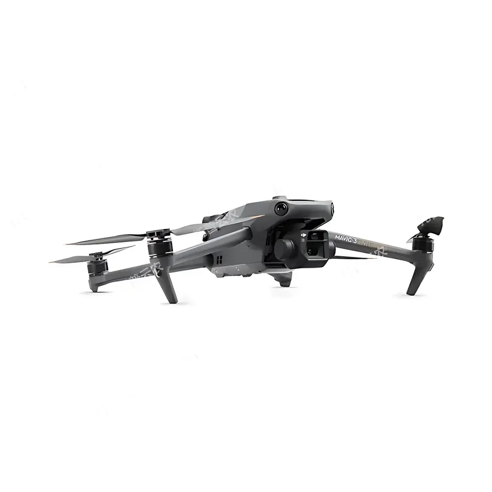
Top Cloud-agri Multi-Spectral Phenotyping UAV Platform
| Brand | Top Cloud-agri |
|---|---|
| Origin | Zhejiang, China |
| Manufacturer Type | OEM/ODM Manufacturer |
| Country of Origin | China |
| Model | TC-MSUAV Series |
| Pricing | Upon Request |
Overview
The Top Cloud-agri Multi-Spectral Phenotyping UAV Platform is a field-deployable remote sensing system engineered for high-resolution, low-altitude acquisition of spectral reflectance data across five discrete wavebands—green (G), red (R), red edge (RE), and near-infrared (NIR)—enabling quantitative plant phenotyping and biophysical parameter estimation. Unlike conventional moisture analyzers or benchtop chemical instruments, this platform operates on the principle of passive optical remote sensing: it captures radiometrically calibrated reflectance signatures from vegetation canopies under natural illumination, then applies radiometric correction, geometric orthorectification, and spectral index derivation to generate spatially explicit maps of vegetation indices (e.g., NDVI, NDRE, GNDVI, CIred-edge), canopy cover, plant height (via DSM generation from multi-view stereo photogrammetry), lodging status, emergence rate, and panicle/tassel count. Its operational architecture integrates aerial imaging physics, photogrammetric processing, and supervised machine learning models trained on ground-truthed agronomic labels—making it functionally distinct from laboratory-based moisture analyzers despite its classification under broader chemical analysis instrument taxonomies.
Key Features
- Multi-crop phenotyping algorithms validated for rice, wheat, maize, soybean, and cotton—supporting stage-specific detection including emergence, tillering, heading, silking, and senescence
- Maize tassel localization module optimized for hybrid seed production: enables sub-decimeter spatial identification of male inflorescences using RE+NIR band ratio thresholds and morphological filtering
- Integrated dual-sensor payload: 20-MP RGB camera (4/3″ CMOS, 24 mm equiv. focal length) co-registered with 5-band multispectral imager (1/2.8″ CMOS, 5 MP, G/R/RE/NIR bands with ±16 nm FWHM bandwidths)
- RTK-enhanced navigation: real-time kinematic GNSS delivers horizontal accuracy of 1 cm + 1 ppm and vertical accuracy of 1.5 cm + 1 ppm—critical for repeatable plot-level monitoring across growing seasons
- Autonomous flight planning with adaptive terrain-following: supports mission scripting via GIS-defined polygon boundaries, automatic altitude adjustment based on digital elevation model (DEM) input, and fail-safe geofencing
- Battery endurance >40 minutes at 12 m/s cruise speed; operational range up to 15 km line-of-sight under Class I wind conditions (≤12 m/s)
- Onboard radiometric calibration: includes dark current subtraction, vignetting correction, and gain scaling (1×–32×) per band to ensure cross-mission spectral consistency
Sample Compatibility & Compliance
This platform does not process physical samples in situ but acquires non-contact optical measurements from living vegetation canopies under field conditions. It complies with ISO 11727:2021 (Agricultural machinery — Remote sensing systems for crop monitoring), adheres to spectral bandpass definitions aligned with ASTM E2795-22 (Standard Practice for Spectral Bandwidth Characterization of Multispectral Sensors), and supports metadata tagging compliant with the ISA-Tab standard for agricultural omics data submission. All derived vegetation indices conform to FAO-recommended calculation protocols. The system architecture supports audit-ready data provenance tracking—including timestamped GPS coordinates, sensor gain settings, exposure values, and atmospheric correction parameters—for GLP-aligned field trials.
Software & Data Management
The proprietary cloud-native platform provides web-based GIS visualization with WGS84 coordinate referencing, layer stacking of orthomosaics, DSMs, and index rasters. It features automated orthorectification using SfM (Structure-from-Motion) photogrammetry, pixel-wise NDVI/NDRE computation, and AI-driven object detection (YOLOv5-based models fine-tuned on >50,000 annotated field images). Data export supports FAO-recommended formats: GeoTIFF for raster layers, CSV/Excel for tabular phenotypic traits, PNG/PDF for publication-grade figures, and JSON-LD for semantic interoperability. Role-based access control (RBAC), 256-bit AES encryption, and full audit logs meet baseline requirements for FDA 21 CFR Part 11-compliant environments where field data feeds into regulatory submissions.
Applications
- Plant breeding programs: high-throughput selection for drought tolerance (via canopy temperature proxy and NDRE dynamics), nitrogen use efficiency (NUE), and lodging resistance
- Academic research: validation of physiological models (e.g., Farquhar photosynthesis model inputs), calibration of satellite-derived LAI estimates, and trait-genotype association mapping
- Commercial farming operations: variable-rate irrigation scheduling based on crop water stress index (CWSI), pre-harvest yield forecasting using panicle density regression, and post-event damage assessment following hail or flooding
- Government agricultural extension: standardized monitoring of national staple crop acreage, early warning of pest outbreaks (e.g., locust swarms via spectral anomaly detection), and subsidy eligibility verification
- Smart farm infrastructure integration: bidirectional API linkage with IoT soil moisture networks, weather stations, and farm management information systems (FMIS) for closed-loop decision support
FAQ
Does this system require ground control points (GCPs) for georeferencing?
No—RTK GNSS positioning eliminates dependency on GCPs for sub-5 cm absolute geolocation accuracy. However, GCPs are recommended for validation in high-precision breeding trials.
Can raw multispectral data be exported for third-party analysis?
Yes: calibrated TIFF stacks (per-band, 16-bit) with embedded EXIF and XMP metadata—including spectral response functions, irradiance reference tags, and lens distortion coefficients—are fully accessible.
Is the platform compatible with existing farm management software?
It supports RESTful API integration with major FMIS platforms (e.g., Granular, Climate FieldView, Agworld) via OAuth2.0 authentication and ISO 11783-10-compliant data schemas.
What is the minimum detectable plant height resolution?
At 30 m AGL flight altitude, vertical resolution is ~3 cm RMS error in DSM generation—sufficient to distinguish tiller emergence from bare soil and quantify canopy height variance within 1 m² plots.
How frequently can the same field be monitored without spectral saturation or plant stress induction?
Optimal revisit interval is 3–5 days during rapid vegetative growth phases; no photoinhibitory effects have been observed in field trials across >200 maize and rice deployments.