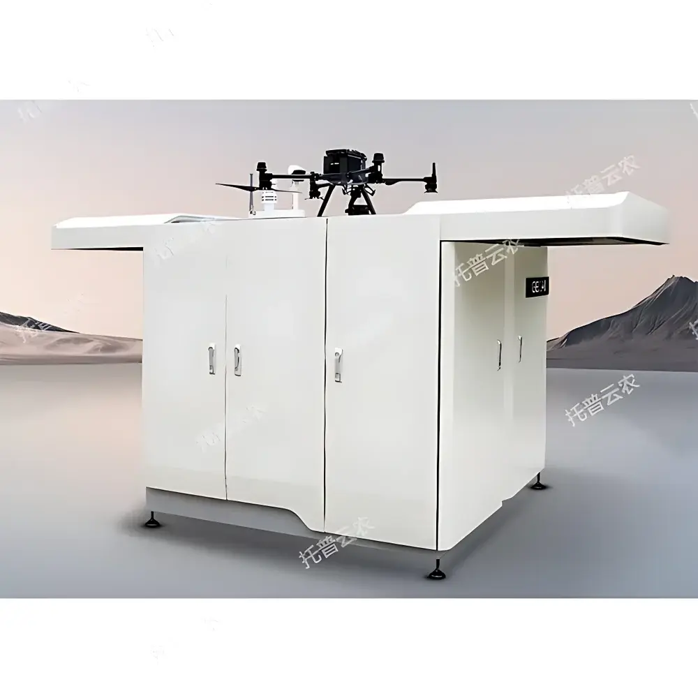
Top Cloud-agri TC-PhenoDrone Pro Autonomous Low-Altitude UAV Inspection System with Integrated Hangar
| Brand | Top Cloud-agri |
|---|---|
| Origin | Zhejiang, China |
| Manufacturer Type | OEM/ODM Producer |
| Region of Origin | Domestic (China) |
| Model | TC-PhenoDrone Pro |
| Pricing | Upon Request |
Overview
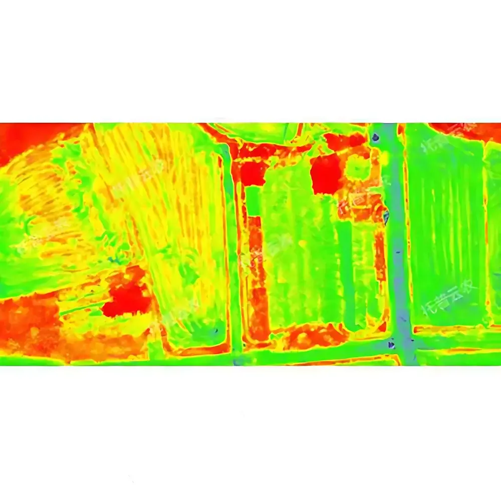
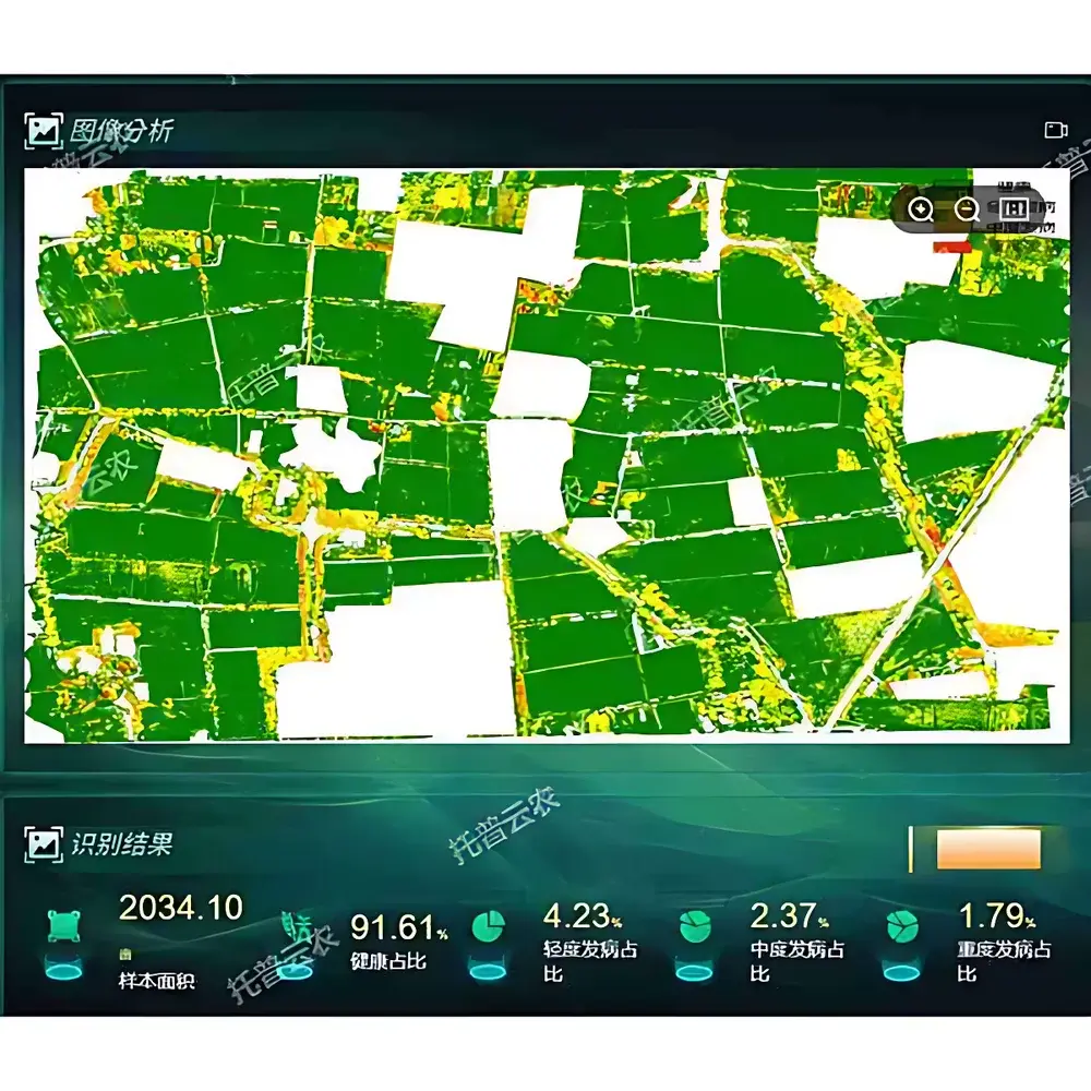
The Top Cloud-agri TC-PhenoDrone Pro is an integrated autonomous low-altitude unmanned aerial vehicle (UAV) inspection system engineered for high-fidelity, repeatable plant phenotyping in controlled agricultural research environments. Designed specifically for fixed-location experimental plots—such as breeding nurseries, variety trials, and longitudinal field studies—the system combines precision flight automation, multi-modal optical sensing, and edge-to-cloud data processing to deliver quantitative, non-destructive phenotypic measurements at scale. Its core operational principle relies on synchronized georeferenced image acquisition using calibrated visible (RGB) and multispectral imaging payloads, followed by algorithmic extraction of biologically meaningful traits—including canopy coverage, vegetation indices (e.g., NDVI, SR, DVI), stand establishment metrics, lodging detection, phenological staging, and 3D structural parameters. The system operates under a deterministic RTK-GNSS navigation architecture, ensuring sub-centimeter spatial repeatability across repeated flights—critical for longitudinal trait monitoring and statistical rigor in genotype-by-environment (G×E) studies.
Key Features
- Fully Autonomous Mission Execution: Integrated hangar enables unattended takeoff, route-following, image capture, landing, battery swap (<2 min), and data upload without human intervention—supporting scheduled or event-triggered missions 24/7.
- Modular Multi-Sensor Payload Architecture: Standard configuration includes a 12.3 MP RGB camera and a 5-band multispectral imager (1/1.8″ sensor, 3.2 MP per band), both protected by sapphire optical windows for durability in field conditions.
- RTK-Enhanced Geospatial Fidelity: Achieves horizontal positioning accuracy of 1 cm + 1 ppm and vertical accuracy of 1.5 cm + 1 ppm—enabling pixel-level alignment across time-series datasets and robust orthomosaic generation.
- Intelligent Flight & Task Orchestration: Web-based platform supports visual flight path design, real-time telemetry overlay (altitude, speed, battery, GNSS status), historical mission replay with georeferenced thumbnail overlays, and automated report generation using pre-deployed AI models.
- Scalable Device Management: Centralized dashboard manages heterogeneous fleets—including multiple TC-PhenoDrone units and corresponding hangars—providing unified visibility into device health, firmware version, location, and operational history.
- Environmental Resilience: Rated for continuous operation in outdoor agricultural settings, including variable wind, dust, light rain, and temperature fluctuations typical of open-field research stations.
Sample Compatibility & Compliance
The TC-PhenoDrone Pro is validated for use across major cereal and row crops—including rice, wheat, maize, and soybean—with trait-specific algorithms trained on regionally representative germplasm. It supports standardized phenotypic measurement protocols aligned with the Plant Phenomics Data Standards (PPDS) framework and facilitates traceable data acquisition compliant with Good Laboratory Practice (GLP) principles. While not certified under FDA 21 CFR Part 11, the system’s audit log functionality—including immutable timestamps, user attribution, and full metadata capture (GPS coordinates, exposure settings, sensor calibration IDs)—supports internal validation workflows required for peer-reviewed publication and regulatory submission preparation. All imagery and derived metrics are stored with FAIR (Findable, Accessible, Interoperable, Reusable) metadata tags in accordance with ISA-Tab conventions.
Software & Data Management
The TC-PhenoDrone Pro operates with a browser-based management suite that provides role-based access control, secure HTTPS communication, and encrypted local storage. Raw images are automatically geo-tagged and uploaded to a configurable cloud or on-premise server. Pre-installed analytical modules include crop emergence rate estimation, panicle counting (for rice/wheat), lodging severity quantification, NDVI time-series interpolation, and thermal anomaly detection. Users may extend functionality via Python-based plugin interfaces compatible with common open-source libraries (e.g., scikit-image, rasterio, OpenCV). All processing pipelines generate versioned outputs with embedded provenance metadata—ensuring reproducibility and facilitating integration with downstream statistical analysis platforms such as R/qtl, TASSEL, or CropScape.
Applications
- Longitudinal monitoring of experimental plots for breeding program decision support
- Non-invasive assessment of abiotic stress responses (e.g., drought-induced canopy temperature shifts, nitrogen deficiency via spectral reflectance)
- Validation of gene-edited or transgenic lines under field conditions
- High-throughput screening of disease resistance using spectral-temporal signatures
- Generation of training datasets for deep learning models targeting morphological or physiological traits
- Supporting digital twin development for agronomic simulation and yield forecasting
FAQ
Is the TC-PhenoDrone Pro compatible with third-party sensors beyond the standard RGB/multispectral payload?
Yes—mechanical, electrical, and software interfaces support integration of optional hyperspectral imagers (≥30 bands), thermal infrared cameras, and LiDAR modules, subject to payload weight and power constraints.
What level of technical support and calibration services does Top Cloud-agri provide?
Customers receive annual factory recalibration certificates for all optical payloads, along with remote diagnostics, firmware updates, and on-site deployment assistance for initial system commissioning.
Can raw data be exported in open formats suitable for academic analysis?
All imagery is delivered in GeoTIFF format with embedded EXIF and XMP metadata; derived trait tables are provided as CSV or HDF5 files, fully compatible with MATLAB, Python, and R environments.
Does the system meet international aviation regulatory requirements for automated BVLOS operations?
The platform complies with China’s CAAC Regulation CCAR-92 for unmanned aircraft systems; for export deployment, users must obtain local civil aviation authority approvals based on national UAS operating rules.
How is data security ensured during transmission and storage?
End-to-end TLS 1.3 encryption is enforced for all communications; local hangar storage uses AES-256 encryption, and cloud backups adhere to ISO/IEC 27001-aligned access controls and retention policies.