Top Cloud-agri TOP-1300 Canopy Analyzer
| Brand | Top Cloud-agri |
|---|---|
| Origin | Zhejiang, China |
| Manufacturer Type | Direct Manufacturer |
| Country of Origin | China |
| Model | TOP-1300 |
| Instrument Principle | Hemispherical Photography (Fisheye Lens-Based Radiative Transfer Modeling) |
| Instrument Type | Portable |
| PAR Spectral Range | 400–700 nm |
| PAR Measurement Range | 0–2000 µmol·m⁻²·s⁻¹ |
| Field of View | 150° (optional 180° fisheye lens) |
| Image Resolution | 768 × 494 pixels |
| Zenith Angle Coverage | 0°–75° (divisible into 10 sectors) |
| Azimuthal Coverage | 360° (divisible into 10 sectors) |
| Power Supply | 7.4 V Li-ion battery pack |
| Interface | USB 2.0 |
| Operating Temperature | 0–55 °C |
Overview
The Top Cloud-agri TOP-1300 Canopy Analyzer is a field-deployable hemispherical imaging system engineered for quantitative structural and radiative characterization of plant canopies. It operates on the principle of fisheye-lens-based hemispherical photography, capturing upward- and downward-facing canopy images under natural illumination to model radiation transfer through vegetation layers. By integrating calibrated fisheye optics (150° native field of view, optionally upgradeable to 180°), a high-stability CCD sensor, and validated radiative transfer algorithms, the instrument derives biophysically meaningful canopy descriptors—including leaf area index (LAI), mean leaf inclination angle (MLA), gap fraction, clumping index, extinction coefficient at multiple solar zenith angles, and vertical PAR transmittance profiles. Designed for ecological realism and measurement repeatability, the TOP-1300 adheres to foundational methodologies outlined in ISO 11727:2022 (optical methods for LAI estimation) and aligns with FAO-recommended protocols for canopy light interception assessment in agroecosystems.
Key Features
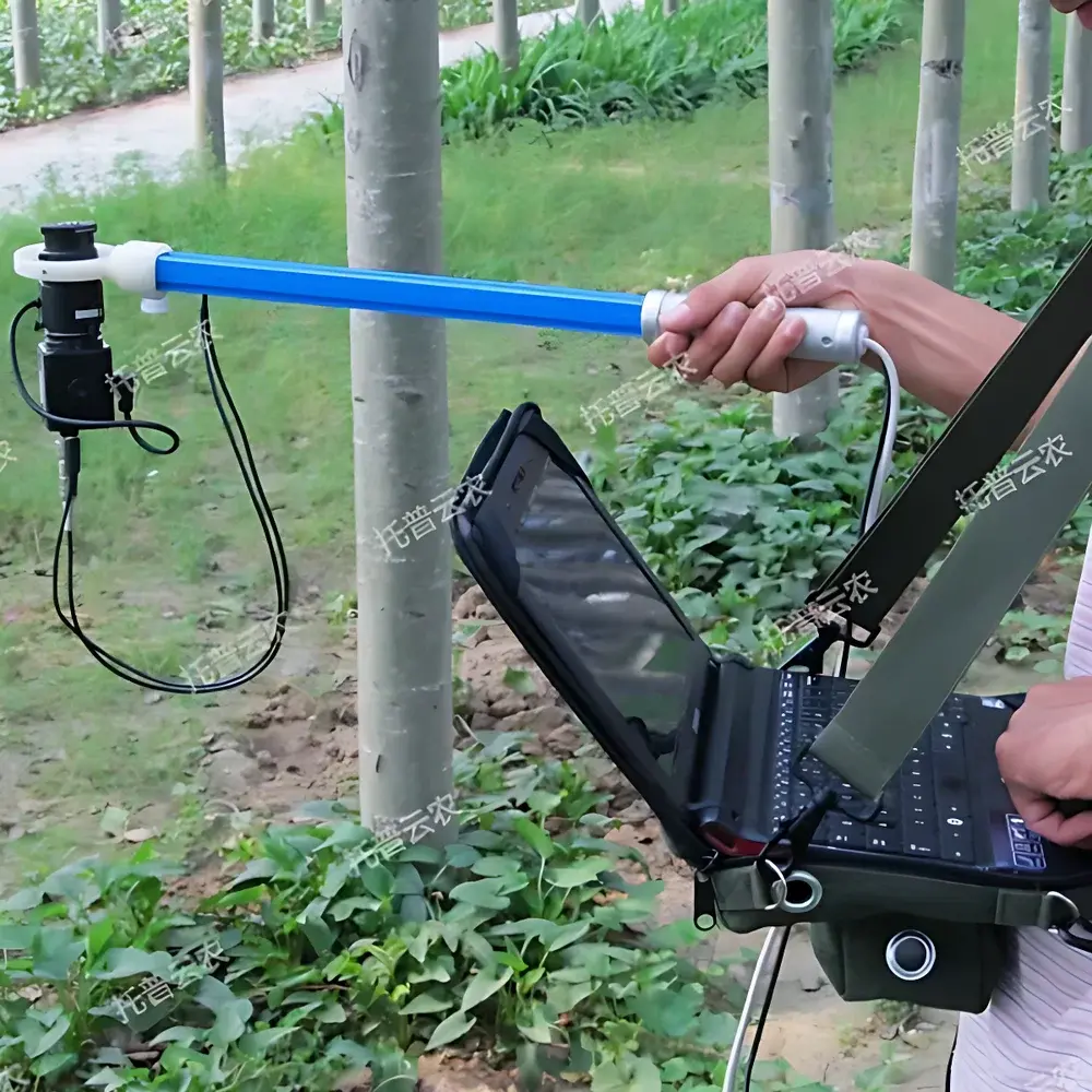
- Non-destructive, in situ acquisition of hemispherical canopy images using a calibrated 150° fisheye lens (180° optional) with automatic horizon-leveling capability to ensure geometric fidelity across uneven terrain.
- Integrated USB 2.0 interface enables real-time image preview, selective frame capture, and direct storage to host PC—eliminating onboard memory constraints and enabling immediate quality control during data collection.
- Modular probe design mounted on an adjustable survey pole allows rapid deployment at multiple canopy heights (e.g., ground level, mid-canopy, above-canopy), facilitating vertical profiling of PAR transmittance and LAI stratification.
- Dual-angle segmentation engine supports independent partitioning of the hemispherical image into 10 zenith sectors (0°–75°) and 10 azimuthal sectors (0°–360°), permitting spatially resolved analysis of directional light transmission and azimuthal heterogeneity in leaf orientation.
- Region-of-interest (ROI) masking function enables manual or semi-automated exclusion of non-canopy elements (e.g., sky obstructions, equipment shadows, adjacent vegetation), improving parameter robustness in complex field settings.
- Field-rated 7.4 V lithium-ion battery pack delivers >8 hours of continuous operation under typical ambient conditions (20–30 °C), supporting full-day campaigns without thermal throttling or voltage drift.
Sample Compatibility & Compliance
The TOP-1300 is optimized for herbaceous and woody vegetation up to 5 m in height, including row crops (maize, soybean, cotton), orchard systems (apple, citrus), vineyards, grasslands, and forest understory surveys. Its PAR-sensitive photodiode array (400–700 nm spectral response) conforms to the Photosynthetically Active Radiation definition per CIE S 026/E:2018 and ASTM E2913-21. Data processing follows widely accepted inversion models—including the Beer–Lambert law for extinction coefficient derivation and the LAI-2000 algorithmic framework for gap fraction-to-LAI conversion—ensuring cross-study comparability. While not certified for GLP/GMP environments, the instrument’s deterministic image capture pipeline, timestamped metadata embedding, and audit-ready export formats (CSV, TIFF, XML) support traceability requirements in academic, governmental, and contract research applications.
Software & Data Management
The proprietary TOP-Canopy Analysis Suite (v3.2+) provides a deterministic, scriptable workflow for raw image calibration, vignetting correction, sky/cloud masking, binary thresholding, and angular sector integration. All derived parameters—including LAI, MLA, gap fraction, and PAR transmittance at user-defined solar elevation angles—are exported in ISO 8601-compliant CSV with embedded measurement context (GPS coordinates, date/time, battery voltage, lens ID). The software supports batch processing of multi-location datasets and generates publication-ready figures: vertical LAI profiles, azimuthal leaf angle distributions, and zenith-angle-resolved extinction curves. Exported data structures are compatible with R (via canopyR), Python (scikit-image, radiative), and MATLAB for secondary modeling, machine learning training, or integration into crop growth simulators (e.g., APSIM, DSSAT).
Applications
- Quantifying light use efficiency (LUE) and radiation use efficiency (RUE) in breeding trials for shade-tolerant or high-LAI cultivars.
- Evaluating canopy architectural responses to drought stress, nitrogen availability, or planting density in field phenotyping platforms.
- Validating outputs from terrestrial laser scanning (TLS) and UAV-based multispectral LAI estimates via ground-truthing.
- Parameterizing radiative transfer modules in ecosystem models (e.g., SCOPE, PROSAIL) used in regional carbon flux estimation.
- Assessing canopy closure dynamics during early-season crop establishment for precision irrigation scheduling.
- Monitoring structural degradation in riparian buffers or post-fire regeneration zones using time-series LAI trajectories.
FAQ
What spectral range does the PAR sensor cover, and how is it calibrated?
The integrated photodiode sensor covers 400–700 nm with cosine-corrected angular response per ISO 9060:2018 Class C specifications. Factory calibration is traceable to NIM (National Institute of Metrology, China) standards; users may perform field recalibration using a reference quantum sensor (e.g., LI-190R).
Can the TOP-1300 operate under overcast conditions?
Yes—hemispherical imaging relies on diffuse skylight rather than direct solar irradiance, making it suitable for cloud-covered days. However, low-contrast images may require adjusted thresholding during analysis.
Is the software compatible with macOS or Linux?
The native TOP-Canopy Analysis Suite runs on Windows 10/11 (64-bit). Exported CSV and TIFF files are fully interoperable with cross-platform scientific computing environments.
How is leveling accuracy maintained during field deployment?
An integrated dual-axis electronic inclinometer provides real-time tilt feedback; the software applies geometric correction when residual pitch/roll exceeds ±1.5°, preserving angular bin integrity in zenith/azimuth segmentation.
Does the system support automated time-series measurements?
No—the TOP-1300 is manually triggered. For unattended monitoring, users integrate its USB output with external dataloggers (e.g., Campbell Scientific CR1000X) via TTL pulse triggering or scheduled PC-based acquisition scripts.