Top Cloud-agri TP-WMS-1L Smart Agricultural Weather Station
| Brand | Top Cloud-agri |
|---|---|
| Origin | Zhejiang, China |
| Manufacturer Type | Manufacturer |
| Country of Origin | Domestic (China) |
| Model | TP-WMS-1L |
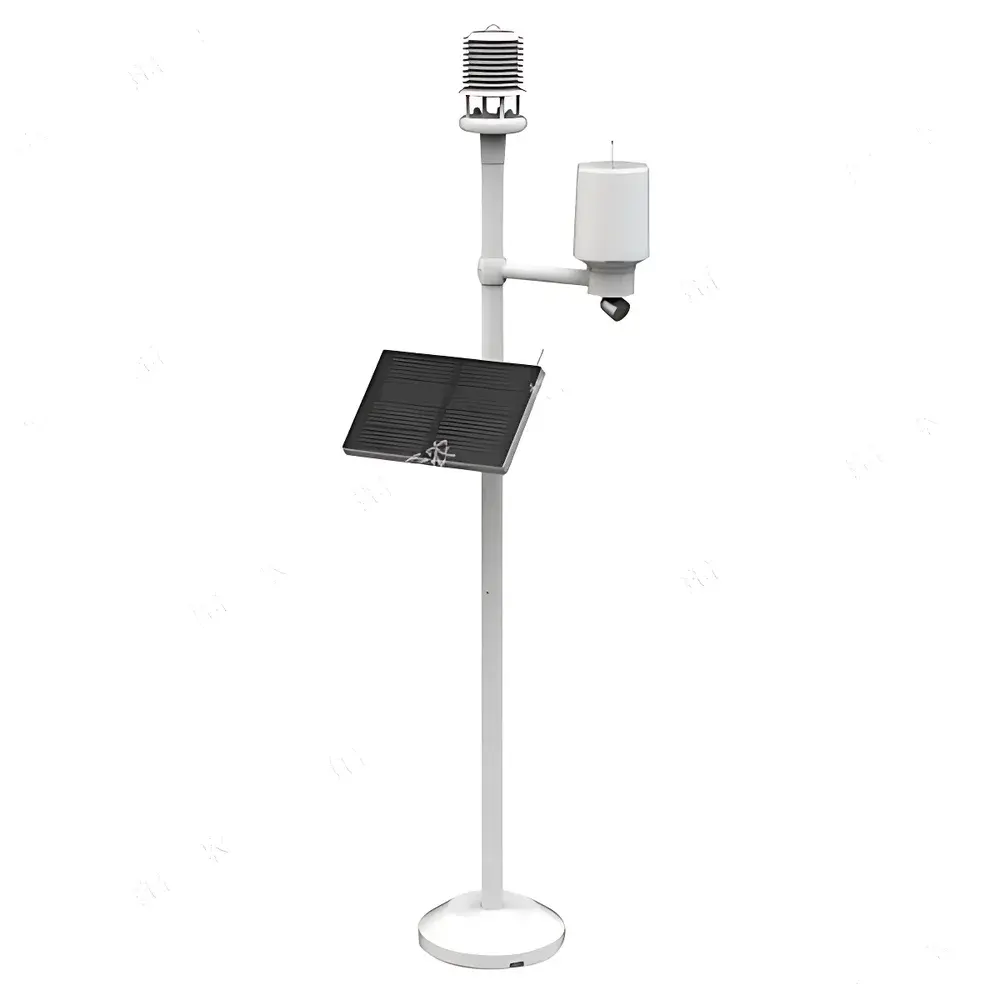
| Instrument Type | Multi-parameter Unmanned Weather Station |
| Communication | 4G CAT1 (supporting China Unicom/China Mobile 2G/4G, China Telecom 4G) |
| Data Storage | Internal TF card (5-year sensor data retention) |
| Positioning | Integrated GPS/BeiDou/Galileo |
| Imaging | CMOS 1/2.7″ sensor, 2 MP (1280×1080), scheduled capture |
| Environmental Parameters | Air Temp (−20–70°C, ±0.4°C), Air RH (0–98% RH, ±2.5% RH), Soil Moisture (0–100% VWC, ±3% in 0–50% range), Soil Temp (−40–70°C, ±0.5°C), Wind Speed (0–60 m/s, ±(0.5 + 0.03v) m/s), Wind Direction (0–360°, ±3°), Rainfall (0–4 mm/day, ±0.4 mm ≤10 mm), Illuminance (0–200,000 lux, ±2% FS) |
Overview
The Top Cloud-agri TP-WMS-1L Smart Agricultural Weather Station is an autonomous, multi-sensor environmental monitoring system engineered for long-term, unattended operation in field-based agricultural and ecological research environments. It implements a distributed IoT architecture with integrated wireless telemetry, enabling real-time acquisition and remote transmission of meteorological and edaphic parameters critical to crop phenology modeling, irrigation scheduling, microclimate characterization, and climate resilience assessment. Unlike conventional single-purpose weather stations, the TP-WMS-1L combines high-fidelity physical sensing—based on calibrated thermistors, capacitive humidity elements, frequency-domain reflectometry (FDR) soil probes, ultrasonic anemometry, tipping-bucket rain gauges, and silicon photodiode lux sensors—with embedded edge computing capabilities and cloud-native data management. Its design adheres to principles of modularity, interoperability, and audit-ready data provenance—making it suitable for use in GLP-aligned agronomic trials, USDA NRCS-supported conservation programs, and ISO 17025-accredited soil–plant–atmosphere continuum studies.
Key Features
- Fully autonomous operation with programmable sampling intervals (1 min to 24 h) and configurable upload cycles via secure HTTPS/MQTT protocols
- Dual-mode data routing: supports direct transmission to user-defined private servers or centralized Top Cloud-agri cloud infrastructure—switchable without hardware reconfiguration
- Multi-constellation GNSS positioning (GPS/BeiDou/Galileo) with altitude estimation, enabling georeferenced time-series analysis and spatial interpolation across distributed sensor networks
- Onboard 2-megapixel imaging module with scheduled capture capability; images timestamped and geotagged prior to cloud ingestion for phenological validation and visual ground-truthing
- Remote diagnostics and over-the-air (OTA) firmware updates via web platform or mobile application, minimizing site visits and operational downtime
- Industrial-grade TF card support for local buffering and failover storage—designed for continuous logging of all 10+ sensor channels at default 15-min intervals for up to five years
- Environmental hardening: IP65-rated enclosure, operating temperature range −25°C to +70°C, and ESD-protected sensor interfaces compliant with IEC 61000-4-2
Sample Compatibility & Compliance
The TP-WMS-1L is validated for deployment across diverse agroecosystems—including open-field row crops, orchards, vineyards, tea plantations, tobacco farms, and forestry plots—where representative microclimatic gradients must be resolved at plot- or sub-field scale. Sensor calibration certificates traceable to NIM (National Institute of Metrology, China) are provided per unit. While not certified to UL/CE for industrial safety, its measurement methodologies align with internationally recognized standards: air temperature/humidity per ISO 7726 and ASHRAE Fundamentals Chapter 17; rainfall per WMO Guide to Meteorological Instruments and Methods of Observation (CIMO Guide, Chapter 5); soil moisture per ASTM D7928-22 (standard test method for determination of soil water content using FDR); and solar irradiance per ISO 9060:2018 Class C spectral response specifications. The system supports export of raw and processed datasets in CSV, JSON, and NetCDF formats—enabling integration into FAO AquaCrop, DSSAT, or R-based agrometeorological workflows.
Software & Data Management
- Cloud-hosted SaaS platform with role-based access control (RBAC), full audit trail, and configurable data retention policies (minimum 10-year archival)
- Time-series visualization engine supporting zoomable trend plots, statistical overlays (min/max/mean/standard deviation), and comparative analysis across multiple stations
- Automated agrometeorological index generation: accumulated growing degree days (GDD), photoperiod duration, effective temperature sum, and thermal time thresholds per crop-specific base temperatures
- Configurable alerting system with email/SMS notifications for parameter excursions—predefined templates available for maize, rice, wheat, soybean, and tea phenophase thresholds
- Image-based phenocam analytics: chronological image stacking, seasonal NDVI proxy derivation (via RGB-to-NDVI conversion), and manual annotation tools for growth stage verification
- API endpoints (RESTful) and webhook integrations for third-party LIMS, farm management software (e.g., Climate FieldView, Granular), or custom dashboard development
Applications
The TP-WMS-1L serves as a foundational node in precision agriculture infrastructure—supporting applications ranging from real-time irrigation advisory systems and frost risk forecasting to long-term climate change impact monitoring in protected cultivation zones. In academic settings, it facilitates undergraduate meteorology labs, graduate-level micrometeorology field courses, and collaborative projects involving UAV-ground sensor fusion. Regulatory agencies utilize its standardized output format for validating localized evapotranspiration models under regional water rights frameworks. Extension services deploy fleets of TP-WMS-1L units to generate hyperlocal mesoscale weather bulletins for smallholder farmer cooperatives—enhancing adaptive capacity through actionable, context-specific forecasts. Its modular sensor architecture also permits expansion with optional CO₂, leaf wetness, or PAR sensors—extending utility into controlled-environment agriculture and post-harvest storage monitoring scenarios.
FAQ
What communication protocols does the TP-WMS-1L support for data transmission?
It uses secure MQTT over 4G CAT1 cellular networks, with fallback to HTTP(S) POST for compatibility with legacy firewalls and proxy environments.
Can the system operate independently without cloud connectivity?
Yes—the onboard data logger maintains full functionality during network outages, storing all measurements locally on the TF card until connection resumes and automatic synchronization occurs.
Is the platform compliant with FDA 21 CFR Part 11 or EU Annex 11 requirements?
While the system provides electronic records with timestamps, user authentication, and immutable audit logs, formal validation documentation for regulated GxP environments must be performed by the end-user per their internal SOPs.
How frequently can images be captured and uploaded?
Capture intervals are fully programmable—from once per hour to once per day—with batch uploads synchronized to data transmission cycles to minimize bandwidth consumption.
Are sensor calibrations NIST-traceable?
Calibrations are traceable to China’s National Institute of Metrology (NIM), which maintains mutual recognition agreements (MRA) with BIPM signatories; NIST traceability requires supplemental cross-calibration by the user or an accredited lab.
Related Products


