Top Cloud-agri TP-WMS-1Z Smart Agricultural Automatic Weather Station
| Brand | Top Cloud-agri |
|---|---|
| Origin | Zhejiang, China |
| Manufacturer Type | Manufacturer |
| Country of Origin | China |
| Model | TP-WMS-1Z |
| Instrument Type | Integrated Agricultural Microclimate Monitoring Station |
| Power Supply | Dual-mode (Solar + LiFePO₄ Battery) |
| Operating Temperature | −30 °C to +55 °C |
| Relative Humidity Range | 5%–98% RH |
| Soil Sensor Depth Layers | 4 (0–20 cm, 20–40 cm, 40–60 cm, 60–100 cm) |
| Data Acquisition Interval | Configurable (Default: 1 h) |
| Data Transmission Interval | Configurable (Default: 2 h) |
| Onboard Storage | TF card (User-expandable) |
| Communication Protocols | GPRS / CDMA / NB-IoT / GSM / 4G / 5G / Wi-Fi / Ethernet / Fiber |
| Positioning Systems | GPS + BeiDou + Galileo |
| Altitude Measurement | Yes |
| Camera Resolution | 2 MP (1920×1080), 2.7″ CMOS sensor |
| LED Display | 640×320 px (128×64 dot matrix), 35 W, 220 V AC powered |
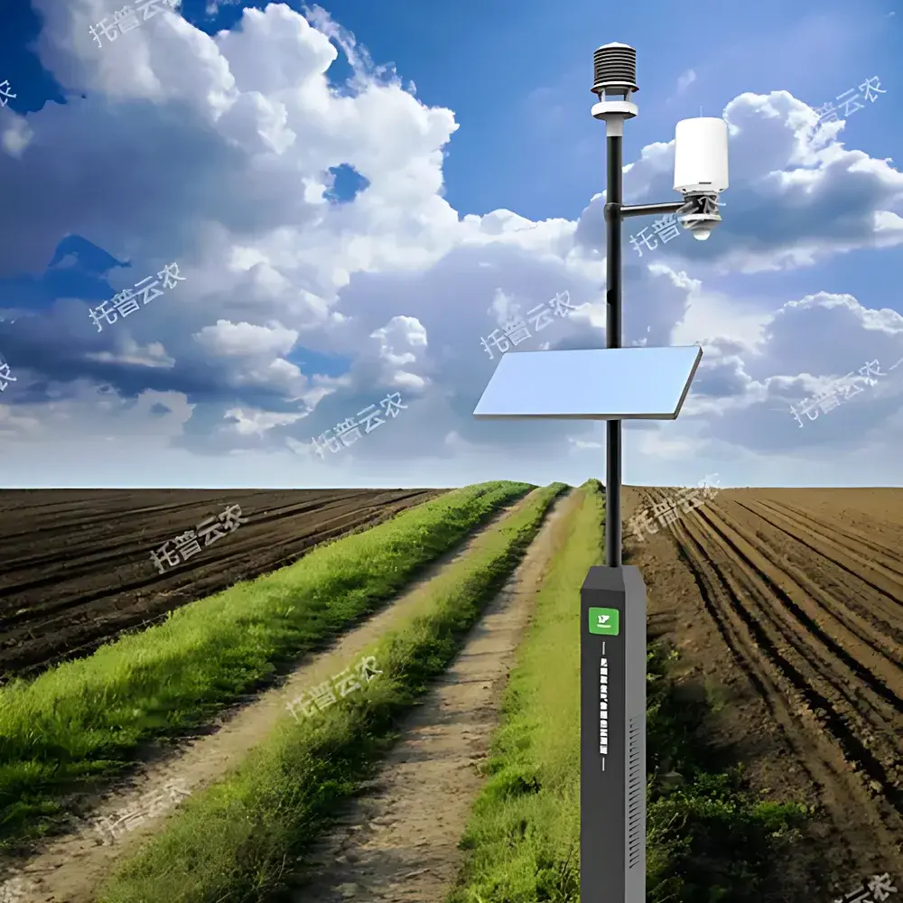
| Enclosure Dimensions (Control Box) | 250 × 149.5 × 375 mm |
| Overall System Height | 3028 mm |
| Mounting Structure | Corrosion-resistant aluminum alloy mast with integrated solar panel & battery housing |
Overview
The Top Cloud-agri TP-WMS-1Z Smart Agricultural Automatic Weather Station is an integrated, field-deployable microclimate monitoring system engineered for precision environmental data acquisition in agronomic, ecological, and educational settings. It operates on the principle of multi-sensor fusion—combining calibrated analog and digital transducers with embedded edge-processing logic—to continuously measure atmospheric, edaphic, and phenological parameters. Unlike conventional standalone weather stations, the TP-WMS-1Z integrates real-time imaging, georeferenced telemetry, and soil profile sensing into a single robust architecture. Its design adheres to international best practices for agricultural meteorology (FAO Agrometeorology Guidelines, ISO 18500 series for environmental sensor performance) and supports long-term, unattended operation under variable climatic stressors—including sub-zero winter conditions and high-humidity subtropical environments.
Key Features
- Multi-layer soil monitoring: Simultaneous measurement of temperature and volumetric water content across four depth intervals (0–20 cm, 20–40 cm, 40–60 cm, 60–100 cm) using non-metallic, PVC-shielded capacitive sensors—eliminating galvanic interference and enabling stable calibration over extended deployment cycles.
- Integrated crop phenology imaging: 2 MP wide-angle camera with programmable capture intervals, supporting time-lapse generation and AI-assisted species-level classification within the field-of-view (trained on common cereal, vegetable, and orchard crops).
- Dual-mode power architecture: Solar-charged LiFePO₄ battery bank (≥30 days autonomy under continuous overcast conditions) coupled with optional AC backup—ensuring uninterrupted operation across remote off-grid sites.
- Multi-constellation GNSS positioning: Concurrent reception from GPS, BeiDou, and Galileo satellites enables sub-5 m horizontal accuracy and automatic altitude registration—critical for elevation-corrected evapotranspiration modeling and spatial interpolation of microclimate gradients.
- Modular communication stack: Hardware-level support for 10+ transmission protocols—including narrowband IoT (NB-IoT), LTE-M, and fiber-optic gateway integration—facilitating seamless interoperability with national agricultural data infrastructures (e.g., China’s National Agro-Meteorological Observation Network).
- Edge-based diagnostics: Real-time health monitoring of sensor integrity, battery state-of-charge, signal SNR, and firmware version—enabling predictive maintenance and remote troubleshooting without site visits.
Sample Compatibility & Compliance
The TP-WMS-1Z is validated for continuous exposure to outdoor agricultural environments, including paddy fields, orchards, grasslands, and peri-urban green belts. All sensors comply with IP67 ingress protection ratings; the solar panel frame and mast structure meet GB/T 20518–2018 (Chinese standard for meteorological station mechanical durability). Soil probes are certified for long-term burial per ASTM D5882–22 (Standard Test Method for In-Situ Density and Moisture Content of Soils Using Nuclear Methods—reference compliance for non-nuclear alternatives). The system supports audit-ready data logging aligned with GLP principles, including timestamped metadata, sensor calibration certificates, and immutable event logs—enabling traceability for research-grade datasets and regulatory submissions.
Software & Data Management
The cloud-native Top Cloud-agri AgroWeather Platform provides role-based access control, ISO/IEC 27001-aligned encryption, and full 21 CFR Part 11-compliant audit trails. Users configure custom alert thresholds per parameter (e.g., soil moisture deficit, heat stress index), trigger automated irrigation advisories, and export time-series data in CSV, Excel, PDF, or NetCDF formats. Advanced analytics modules include FAO-56 Penman-Monteith reference ET calculation, growing degree day (GDD) accumulation, photoperiod tracking, and root-zone water balance modeling. Historical datasets integrate with third-party GIS platforms (QGIS, ArcGIS Online) via RESTful API, and support federated queries across regional station networks—enabling cross-site comparative studies and climate-smart advisory development.
Applications
- Educational outreach: Deployed in K–12 schoolyards and university agroecology labs to demonstrate real-world meteorological principles—supporting STEM curricula with live data feeds, student-configurable sampling schedules, and classroom dashboard visualization.
- Precision agriculture: Provides input data for variable-rate irrigation scheduling, pest phenology forecasting (e.g., rice stem borer emergence models), and yield gap analysis through correlation with satellite-derived NDVI time series.
- Ecological monitoring: Supports long-term studies of microclimate buffering in agroforestry systems, grassland resilience under drought, and urban heat island mitigation in peri-urban parks.
- Extension service digitization: Enables county-level agricultural bureaus to aggregate station-level data into provincial dashboards—feeding early-warning systems for frost, hail, or excessive rainfall events.
FAQ
What is the default data transmission interval, and can it be modified remotely?
Yes—the default upload frequency is every 2 hours, but users may adjust this via the web portal or mobile app without physical access to the station.
Does the system support integration with national or provincial agricultural data platforms?
Yes—TP-WMS-1Z complies with the China National Standard GB/T 35273–2020 for data interface specifications and has been deployed in over 12 provincial agro-meteorological information systems.
How is sensor calibration maintained during long-term deployment?
Each sensor ships with NIST-traceable calibration certificates; field recalibration is supported via platform-initiated zero-point checks and user-uploaded reference measurements.
Can the LED display operate independently of the cloud platform?
Yes—the local 640×320 pixel display shows real-time values, battery status, and connection indicators even during network outages.
Is the soil moisture sensor affected by soil salinity or clay content?
The integrated dielectric sensor employs temperature-compensated TDR algorithms and includes built-in salinity correction coefficients—validated across EC ranges up to 8 dS/m and clay contents up to 45%.
Related Products


