Top Cloud-agri TPN-GTL-GT1 Ground-Track High-Throughput Plant Phenotyping Platform
| Brand | Top Cloud-agri |
|---|---|
| Origin | Zhejiang, China |
| Manufacturer Type | Direct Manufacturer |
| Region of Origin | Domestic (China) |
| Model | TPN-GTL-GT1 |
| Pricing | Upon Request |
Overview
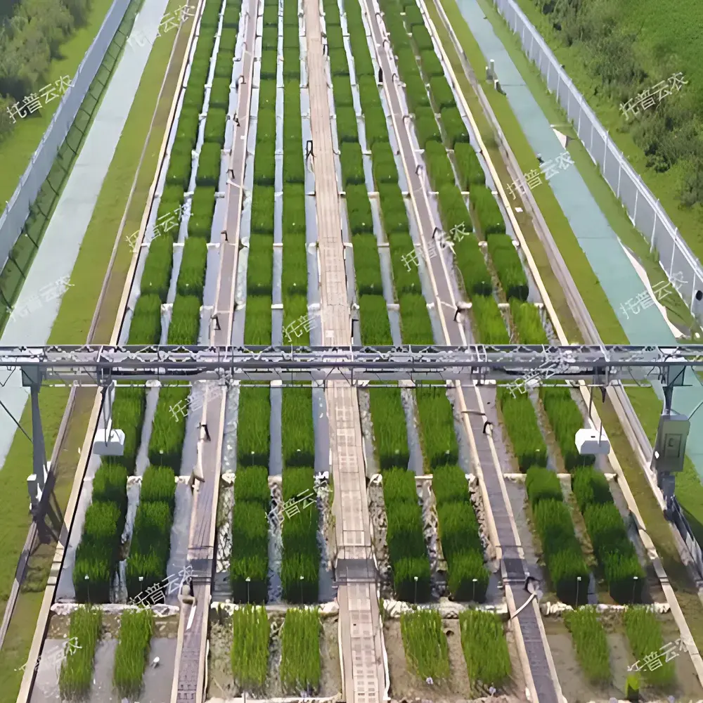
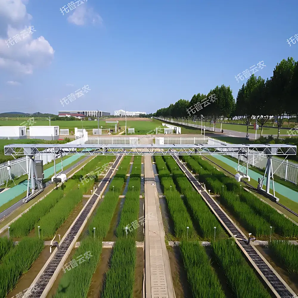
The Top Cloud-agri TPN-GTL-GT1 Ground-Track High-Throughput Plant Phenotyping Platform is an engineered field-deployable phenotyping system designed for long-term, non-destructive, in situ monitoring of dynamic plant phenotypic responses under controlled or natural environmental gradients. Based on a robust gantry architecture mounted on fixed ground rails, the platform integrates modular optical sensing modules to capture spatiotemporal variations in morphological, physiological, structural, and thermal traits across individual plants or canopy-level populations. Its measurement principle relies on synchronized multi-modal imaging—combining visible-light photogrammetry, hyperspectral reflectance spectroscopy, time-of-flight or structured-light 3D scanning, and uncooled microbolometer-based infrared thermography—to quantify traits with reproducible spatial registration and temporal resolution. This architecture enables longitudinal studies of genotype × environment (G×E) interactions, particularly in breeding programs targeting drought tolerance, heat resilience, nitrogen use efficiency, and photosynthetic performance under field conditions.
Key Features
- Field-Adapted Gantry Architecture: Low-profile ground-track mounting allows stable deployment across uneven terrain, irrigation furrows, and variable row spacing without soil disturbance; supports continuous operation over multiple growing seasons.
- Modular Multi-Sensor Integration: Central imaging carriage accommodates interchangeable sensor payloads—including RGB cameras (≥12 MP, global shutter), push-broom hyperspectral imagers (400–1000 nm, 5 nm spectral resolution), stereo-vision or LiDAR-based 3D scanners (±2 mm height accuracy), and radiometrically calibrated thermal cameras (±0.5 °C accuracy, 640 × 512 resolution).
- Automated Trait Quantification: Onboard edge-computing unit executes crop-specific AI models trained on annotated field datasets; outputs standardized trait descriptors compliant with MIAPPE (Minimum Information About a Plant Phenotyping Experiment) metadata standards.
- Sub-Daily Temporal Resolution: Programmable scan frequency from hourly to diurnal cycles; position repeatability ≤ ±1 mm per pass ensures pixel-level co-registration across time series.
- Environmental Synchronization (Optional): Integrated weather station module records ambient temperature, relative humidity, PAR (photosynthetically active radiation), and precipitation at 1 Hz sampling—time-stamped and aligned with image acquisition events.
Sample Compatibility & Compliance
The platform is validated for use with herbaceous monocots and dicots including maize, rice, wheat, soybean, tomato, and Arabidopsis thaliana across vegetative and reproductive stages. Sensor configurations comply with ISO 11727 (optical measurement of plant surface temperature), ASTM E1933 (infrared thermography calibration), and FAO-recommended protocols for canopy NDVI derivation. Data acquisition workflows support GLP-aligned audit trails: all image metadata (GPS geotags, UTC timestamps, sensor calibration IDs, exposure parameters) are embedded in EXIF/XMP headers. Raw data archives conform to FAIR principles (Findable, Accessible, Interoperable, Reusable), with optional integration into ISA-Tab or BrAPI-compliant repositories.
Software & Data Management
The proprietary PhenotypeStudio software suite provides web-based remote access for mission planning, real-time telemetry monitoring, and batch processing. It implements role-based user permissions and supports 21 CFR Part 11-compliant electronic signatures for critical analysis steps. All processed outputs—including segmented masks, point clouds, spectral indices, thermal maps, and derived biophysical parameters (e.g., stomatal conductance proxy, leaf area index, biomass estimates)—are stored in a PostgreSQL database with automatic versioning. Export formats include CSV, NetCDF4 (CF-compliant), GeoTIFF, and JSON-LD for interoperability with Crop Ontology and PlantCV pipelines. Data encryption (AES-256) applies both at rest and during TLS 1.3-secured transmission.
Applications
- High-throughput screening of abiotic stress tolerance (drought, heat, salinity) using thermal canopy depression and spectral water index trajectories.
- Quantitative assessment of photosynthetic efficiency via chlorophyll fluorescence proxies derived from RGB + NIR band ratios.
- Dynamic modeling of organ growth kinetics—stem elongation rate, leaf expansion velocity, tiller emergence timing—using time-series 3D reconstruction.
- Calibration and validation of remote-sensing algorithms (e.g., Sentinel-2, UAV-based NDVI) through ground-truthed, plot-level spectral and structural measurements.
- Phenomic-assisted breeding pipelines requiring traceable, standardized trait data for genome-wide association studies (GWAS) and genomic selection models.
FAQ
What is the maximum operational width and length coverage per installation?
Standard rail segments support up to 100 m linear deployment; custom configurations extend beyond 500 m with distributed power and communication nodes.
Can the system operate autonomously during rain or low-light conditions?
Yes—enclosed sensor housings meet IP65 rating; thermal and LiDAR modules function independently of ambient illumination; RGB and hyperspectral modules activate only under programmable lux thresholds.
Is raw sensor data accessible for third-party algorithm development?
Yes—full-resolution raw frames (including radiometrically corrected thermal cubes and hyperspectral hypercubes) are available via secure SFTP or local NAS export, with documented calibration coefficients and geometric correction parameters.
How is system calibration maintained over seasonal deployment?
Automated daily dark-current and flat-field corrections; annual factory recalibration service includes spectral response verification and LiDAR distance accuracy validation against NIST-traceable targets.
Does the platform support integration with existing farm management information systems (FMIS)?
Yes—RESTful API and MQTT endpoints enable bidirectional synchronization with platforms such as FarmLogs, Granular, and custom LIMS deployments using JSON/Schema.org-compliant payloads.